File:EasternBloc BorderChange38-48-tr.png
Jump to navigation
Jump to search

Size of this preview: 369 × 600 pixels. Other resolutions: 147 × 240 pixels | 630 × 1,024 pixels.
Original file (630 × 1,024 pixels, file size: 229 KB, MIME type: image/png)
Captions
Captions
Add a one-line explanation of what this file represents

|
File:EasternBloc BorderChange38-48-tr.svg is a vector version of this file. It should be used in place of this PNG file when not inferior.
File:EasternBloc BorderChange38-48-tr.png → File:EasternBloc BorderChange38-48-tr.svg
For more information, see Help:SVG. |
 |
Summary
[edit]
| Description |
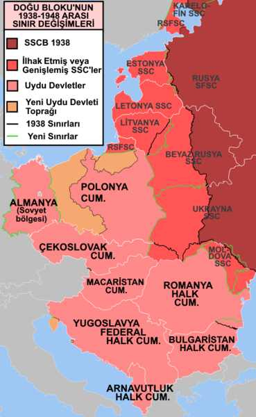
English: !!!COPY-PASTE DESCRIPTION FROM ORGINIAL WORK!!!
e* Description: Former Eastern Bloc area border changes between 1938 and 1948. Source: Map borders primarily based on File:EC12-1986 European Community map.svg and File:Blank map of Europe in 1920.svg. Author: Mosedschurte, June 1, 2009 The border and other changes include: The creation of the satellite states (note: this was before the Tito-Stalin split and the Hoxha 1960 split) The annexation of the Baltic states The annexation of the territory encompassing most of the Moldavian SSR. The Transnistria transfer from the Ukrainian SSR to the Moldavian SSR The annexation of northern Bukovina, the Hertza region and northern Bessarabia into the Ukrainian SSR. The annexation of the area in 1948 approximating the Izmail Oblast into the Ukrainian SSR The western part of the Territories of Poland annexed by the Soviet Union The annexation into Poland of part of East Prussia and the territories east of the Oder-Neisse line from Germany The annexation into Poland of the Free City of Danzig The annexation of the the area now approximating the Kaliningrad Oblast into the RSFSR The annexation into Bulgaria of Southern Dobruja from Romania The annexation into Czechoslovakia of the Bratislava Bridgehead transfer from Hungary The transfer of the Latvian SSR eastern Abrene district to the RSFSR The transfer of Estonian SSR territories north and South of Lake Peipus to the RSFSR The annexation of the Vilnius region from Poland into what was in 1948 the Lithuanian SSR The annexation of part of the area approximating Karelo-Finnish SSR, and portions then transferred to the RSFSR (part of the Leningrad Oblast) The annexation into the Ukrainian SSR of Carpathian RutheniaThe annexation into Yugoslavia of the Italian Istria peninsula, Fiume and Zadar. |
| Date | |
| Source |
this file's original version: https://commons.wikimedia.org/wiki/File:EasternBloc_BorderChange38-48.svg i edited this file: https://meta.wikimedia.org/wiki/File:EasternBloc_BorderChange38-48-Blank.svg |
| Author |
i edited (Modern primat) https://commons.wikimedia.org/wiki/User:Modern_primat he edited what i edit (باسم) https://commons.wikimedia.org/wiki/User:%D8%A8%D8%A7%D8%B3%D9%85 original creator (Mosedschurte) https://commons.wikimedia.org/wiki/User:Mosedschurte |
Licensing
[edit]
This file is licensed under the Creative Commons Attribution-Share Alike 3.0 Unported license.
- You are free:
- to share – to copy, distribute and transmit the work
- to remix – to adapt the work
- Under the following conditions:
- attribution – You must give appropriate credit, provide a link to the license, and indicate if changes were made. You may do so in any reasonable manner, but not in any way that suggests the licensor endorses you or your use.
- share alike – If you remix, transform, or build upon the material, you must distribute your contributions under the same or compatible license as the original.
File history
Click on a date/time to view the file as it appeared at that time.
| Date/Time | Thumbnail | Dimensions | User | Comment | |
|---|---|---|---|---|---|
| current | 22:46, 6 December 2020 | | 630 × 1,024 (229 KB) | Modern primat (talk | contribs) | Uploaded a work by i edited (Modern primat) https://commons.wikimedia.org/wiki/User:Modern_primat he edited what i edit (باسم) https://commons.wikimedia.org/wiki/User:%D8%A8%D8%A7%D8%B3%D9%85 original creator (Mosedschurte) https://commons.wikimedia.org/wiki/User:Mosedschurte from this file's original version: https://commons.wikimedia.org/wiki/File:EasternBloc_BorderChange38-48.svg i edited this file: https://meta.wikimedia.org/wiki/File:EasternBloc_BorderChange38-48-Blank.svg with UploadWizard |
You cannot overwrite this file.
File usage on Commons
There are no pages that use this file.
File usage on other wikis
The following other wikis use this file:
- Usage on ar.wikipedia.org