File:Elitserien Ishockey Karta.jpg
Jump to navigation
Jump to search
Size of this preview: 312 × 599 pixels. Other resolutions: 125 × 240 pixels | 352 × 676 pixels.
Original file (352 × 676 pixels, file size: 65 KB, MIME type: image/jpeg)
Captions
Captions
Add a one-line explanation of what this file represents
| Description |
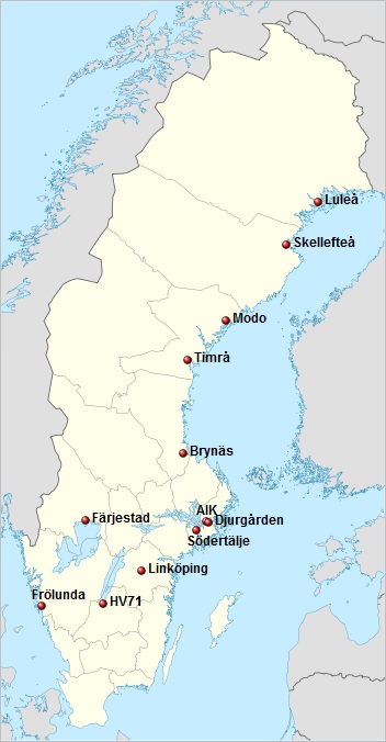
Deutsch: Positionskarte von Schweden Quadratische Plattkarte, N-S-Streckung 190 %. Geographische Begrenzung der Karte: * N: 69.5° N * S: 55.1° N * W: 10.4° O * O: 24.6° O English: Location map of Sweden Equirectangular projection, N/S stretching 190 %. Geographic limits of the map: * N: 69.5° N * S: 55.1° N * W: 10.4° E * E: 24.6° E
with locations of the Elitserien 2010/2011 teams |
| Date | (UTC) |
| Source | |
| Author |
|
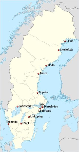
| This is a retouched picture, which means that it has been digitally altered from its original version. Modifications: with locations of the Elitserien 2010/2011 teams. The original can be viewed here: Sweden location map.svg:
|
I, the copyright holder of this work, hereby publish it under the following licenses:
This file is licensed under the Creative Commons Attribution-Share Alike 3.0 Unported license.
- You are free:
- to share – to copy, distribute and transmit the work
- to remix – to adapt the work
- Under the following conditions:
- attribution – You must give appropriate credit, provide a link to the license, and indicate if changes were made. You may do so in any reasonable manner, but not in any way that suggests the licensor endorses you or your use.
- share alike – If you remix, transform, or build upon the material, you must distribute your contributions under the same or compatible license as the original.

|
Permission is granted to copy, distribute and/or modify this document under the terms of the GNU Free Documentation License, Version 1.2 or any later version published by the Free Software Foundation; with no Invariant Sections, no Front-Cover Texts, and no Back-Cover Texts. A copy of the license is included in the section entitled GNU Free Documentation License. |
You may select the license of your choice.
Original upload log
[edit]
This image is a derivative work of the following images:
- File:Sweden_location_map.svg licensed with Cc-by-sa-3.0, GFDL
- 2009-01-27T09:24:12Z Erik Frohne 954x1837 (2870529 Bytes) Added missing border Scania-Blekinge [[Category:Location maps of Sweden]]
- 2008-08-29T08:22:02Z NordNordWest 954x1837 (2868511 Bytes)
- 2008-08-29T08:18:13Z NordNordWest 954x1837 (1529461 Bytes)
- 2008-07-30T11:32:56Z NordNordWest 954x1836 (1527204 Bytes) optimized
- 2008-07-15T18:28:06Z NordNordWest 954x1836 (2123748 Bytes) {{Information |Description= {{de|Positionskarte von [[:de:Schweden|Schweden]]}} Quadratische Plattkarte, N-S-Streckung 190 %. Geographische Begrenzung der Karte: * N: 69.5° N * S: 55.1° N * W: 10.4° O * O: 24.6° O {{en|Lo
Uploaded with derivativeFX
File history
Click on a date/time to view the file as it appeared at that time.
| Date/Time | Thumbnail | Dimensions | User | Comment | |
|---|---|---|---|---|---|
| current | 00:19, 29 May 2010 | | 352 × 676 (65 KB) | Ho0lmgren (talk | contribs) | {{Information |Description={{de|Positionskarte von Schweden}} Quadratische Plattkarte, N-S-Streckung 190 %. Geographische Begrenzung der Karte: * N: 69.5° N * S: 55.1° N * W: 10.4° O * O: 24.6° O {{en|Location map of [[:en:Sweden|Swed |
You cannot overwrite this file.
File usage on Commons
There are no pages that use this file.