File:EmpireFrench.png
Jump to navigation
Jump to search

Size of this preview: 800 × 407 pixels. Other resolutions: 320 × 163 pixels | 640 × 325 pixels | 1,024 × 521 pixels | 1,280 × 651 pixels | 2,753 × 1,400 pixels.
Original file (2,753 × 1,400 pixels, file size: 193 KB, MIME type: image/png)
Captions
Captions
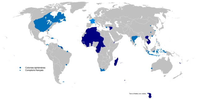
French colonial empires from 1542 to 1980. Light blue: First colonial empire. Dark blue: Second colonial empire.


|
This historical map image could be re-created using vector graphics as an SVG file. This has several advantages; see Commons:Media for cleanup for more information. If an SVG form of this image is available, please upload it and afterwards replace this template with
{{vector version available|new image name}}.
It is recommended to name the SVG file “EmpireFrench.svg”—then the template Vector version available (or Vva) does not need the new image name parameter. |
Summary
[edit]
| Description |
English: Colonial empire from 1542 to 1980
Dark Blue: Second colonial empire Light Blue: First colonial empire |
| Date | 01/06/2010 |
| Source | Own work |
| Author | Gd21091993 |
Licensing
[edit]
| I, the copyright holder of this work, release this work into the public domain. This applies worldwide. In some countries this may not be legally possible; if so: I grant anyone the right to use this work for any purpose, without any conditions, unless such conditions are required by law. |
File history
Click on a date/time to view the file as it appeared at that time.
| Date/Time | Thumbnail | Dimensions | User | Comment | |
|---|---|---|---|---|---|
| current | 17:02, 4 April 2022 | | 2,753 × 1,400 (193 KB) | Oort kuipert (talk | contribs) | added territory in india and america, source : https://commons.wikimedia.org/wiki/File:New_France_(orthographic_projection).svg https://commons.wikimedia.org/wiki/File:French_possessions_in_the_Americas_(1534-1803).png https://commons.wikimedia.org/wiki/File:Evolution_empire.png |
| 15:41, 30 March 2022 |  | 2,753 × 1,400 (194 KB) | Oort kuipert (talk | contribs) | added colonies under Napoléon I according to https://upload.wikimedia.org/wikipedia/commons/3/33/French_Empire_on_World_1812.png | |
| 12:01, 8 October 2017 |  | 2,753 × 1,400 (116 KB) | SUM1 (talk | contribs) | Fixes: unshaded Spanish Morocco (Cape Juby), Equatorial Guinea, Nigeria, Southern Cameroons, Zanzibar, Czech border | |
| 13:46, 2 March 2016 |  | 2,753 × 1,400 (99 KB) | Frans45 (talk | contribs) | in New Caledonia archipelago only the big island was marked, I added : îles Loayutés, île de Pins, îles Chesterfield | |
| 15:29, 1 June 2010 |  | 2,753 × 1,400 (316 KB) | Gd21091993 (talk | contribs) | {{Information |Description={{fr|1=Carte de l'Empire Colonial Français de 1542 à 1980 }} |Source={{own}} |Author=Gd21091993 |Date=01/06/2010 |Permission= |other_versions= }} |
You cannot overwrite this file.
File usage on Commons
The following 3 pages use this file:
File usage on other wikis
The following other wikis use this file:
- Usage on ar.wikipedia.org
- Usage on ast.wikipedia.org
- Usage on azb.wikipedia.org
- Usage on bg.wikipedia.org
- Usage on br.wikipedia.org
- Usage on ca.wikipedia.org
- Usage on cs.wikipedia.org
- Usage on el.wikipedia.org
- Usage on en.wikipedia.org
- Empire
- User:Dimadick
- French colonial flags
- Analysis of European colonialism and colonization
- Evolution of the French colonial empire
- Political history of the world
- User:Jethwarp
- Timeline of European imperialism
- List of modern great powers
- User:Jethwarp/UBX/French Colonial empire
- Category:Wikipedians interested in European colonial empires
- Liberation of France
- Honor killings by region
- User:Falcaorib/France
- Usage on en.wikibooks.org
- Usage on en.wikiquote.org
- Usage on en.wiktionary.org
- Usage on eo.wikipedia.org
- Usage on es.wikipedia.org
- Usage on eu.wikipedia.org
- Usage on fa.wikipedia.org
- Usage on fi.wikipedia.org
- Usage on fr.wikipedia.org
- Usage on fr.wiktionary.org
- Usage on gl.wikipedia.org
View more global usage of this file.