File:Endurance fr.svg
From Wikimedia Commons, the free media repository
(Redirected from File:Endurance.svg)

Size of this PNG preview of this SVG file: 675 × 600 pixels. Other resolutions: 270 × 240 pixels | 540 × 480 pixels | 864 × 768 pixels | 1,152 × 1,024 pixels | 2,304 × 2,048 pixels | 900 × 800 pixels.
Original file (SVG file, nominally 900 × 800 pixels, file size: 98 KB)
File information
Structured data
Captions
Captions
Add a one-line explanation of what this file represents
| DescriptionEndurance fr.svg |
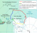
Français : Trajet de l'Expédition Endurance, quatrième expédition brittanique en Antarctique au XXème siècle.
English: Route of Imperial Trans-Antarctic Expedition (with the ship Endurance), fourth english expedition in XX century in Antarctic. PLAN KEY : Red : The Endurance 's route. Yellow : drift of the Endurance jammed in ice. Green : After the shipwreck under ices, drift on ice field, and journey with canot towards Elephant isle. Blue : dinghy James Caird's route towards South Georgia.
Deutsch: Fahrt von die de:Expedition Endurance, vierte brittanischen Spedition nach Antarktis im 20. Jahrhundert. LEGENDE : Rot : die Reise der Endurance. Gelb : das Abdriften von Endurance, in den Spiegeln. Grün: nachdem das Schiff geflossen ist, abdrift auf Packeis, und Reise nach dem Boot zur Insel des Elefanten. Blau: die Reise des Bootes Jamesz Caird bis südliches Georgien.
Español: Viaje de la Expedición Endurance (Expedición Imperial Trans-Antártica), que es la cuarta expedición inglesa en el siglo 20. PIE : Rojo: el viaje del Endurance. Amarillo: flujo de la Endurance atestada en hielo. Verde : Después del naufragio en hielos, vaya a la deriva sobre el campo de hielo, y el viaje con barcas hacia la isla de Elefante. Azul: : viaje con el James Caird hacia la Georgia del sul.
Italiano: Cf. Spedizione Endurance. Rosso: La Endurance percorso. Giallo: moto della Endurance si bloccò in ghiaccio. Verde : Dopo il naufragio sotto ghiacci, vada alla deriva su campo di ghiaccio, e viaggi con canotti verso isola di Elefante. Blu : percorso del canotto James Caird. |
| Date | |
| Source |
Own work Image:James caird voyage1.PNG + Image:Antarctic fr.svg + Image:ShackletonEnduranceCarte.png |
| Author | Bourrichon |
| Permission (Reusing this file) |
This file is licensed under the Creative Commons Attribution-Share Alike 3.0 Unported license.
|
| Other versions |
|
This map was improved or created by the Wikigraphists of the Graphic Lab (fr). You can propose images to clean up, improve, create or translate as well. |
| This SVG file contains embedded text that can be translated into your language, using any capable SVG editor, text editor or the SVG Translate tool. For more information see: About translating SVG files. |
File history
Click on a date/time to view the file as it appeared at that time.
| Date/Time | Thumbnail | Dimensions | User | Comment | |
|---|---|---|---|---|---|
| current | 12:16, 24 November 2016 |  | 900 × 800 (98 KB) | Jc86035 (talk | contribs) | "Îles Orcades" → "Îles Orcades du Sud" |
| 06:21, 11 November 2015 |  | 900 × 800 (98 KB) | Odysseus1479 (talk | contribs) | Corriger (intervertir) mi. et km | |
| 13:32, 28 May 2014 |  | 900 × 800 (98 KB) | Jc86035 (talk | contribs) | Fixed the accent on "Géorgie du Sud" | |
| 10:12, 28 May 2014 |  | 900 × 800 (98 KB) | Jc86035 (talk | contribs) | Fixed a few errors | |
| 16:26, 27 May 2014 |  | 900 × 800 (98 KB) | Jc86035 (talk | contribs) | Changed fonts to those that render, cleaned up | |
| 09:03, 17 April 2008 |  | 900 × 800 (167 KB) | Actam (talk | contribs) | Fixed raster image, fixed paths (used lines instead of fills), svg cleanup (really really needed it!) Used all open fonts (no Arial, font not supported!) | |
| 17:19, 28 March 2008 |  | 900 × 800 (2.03 MB) | Bourrichon (talk | contribs) | {{Information |Description= {{fr|Trajet de l'Expédition ''Endurance'', quatrième expédition brittanique en Antarctique au XXème siècle.}} {{en|Route of [[:en:Imperial Trans-Antarctic Expedition|Imperial Trans-Antarctic E |
You cannot overwrite this file.
File usage on Commons
The following 10 pages use this file:
- User:4ing/Antarctica/2015-11
- User:4ing/Antarctica/2016-11
- User:Chumwa/OgreBot/Potential transport maps/2016 November 21-30
- User:Chumwa/OgreBot/Transport Maps/2015 November 11-20
- User:Chumwa/OgreBot/Transport Maps/2016 November 21-30
- User:Chumwa/OgreBot/Travel and communication maps/2016 November 21-30
- Commons:Graphic Lab/Map workshop/Archive/2016
- File:Endurance.svg (file redirect)
- File:Endurance en.svg
- File:James Caird fr.svg
File usage on other wikis
The following other wikis use this file:
- Usage on fr.wikipedia.org
- Usage on zh.wikipedia.org
Metadata
This file contains additional information such as Exif metadata which may have been added by the digital camera, scanner, or software program used to create or digitize it. If the file has been modified from its original state, some details such as the timestamp may not fully reflect those of the original file. The timestamp is only as accurate as the clock in the camera, and it may be completely wrong.
| Width | 900 |
|---|---|
| Height | 800 |


