File:Europe 814.png
Jump to navigation
Jump to search

Size of this preview: 777 × 600 pixels. Other resolutions: 311 × 240 pixels | 622 × 480 pixels | 995 × 768 pixels | 1,280 × 988 pixels | 1,393 × 1,075 pixels.
Original file (1,393 × 1,075 pixels, file size: 169 KB, MIME type: image/png)
Captions
Captions
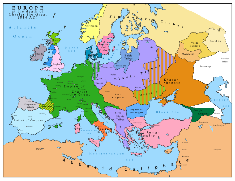
I think this map is not clear and correct at all , where are the Moldavians and Transilvanians and other witch Romania now days is, plus the hungarians are from AVAR people

Summary
[edit]| Description |
English: Map of Europe after the death of Charles the Great (814 AD). Original map made by Charles Colbeck, The Public Schools Historical Atlas (1905). |
|||
| Date | 2009-04-15. Source date: 1905 by Longmans, Green; New York, London, Bombay 1905. | |||
| Source | Own work based on: Europe 814.jpg | |||
| Author | Bukkia (talk · contribs) | |||
| Other versions |
|


Licensing
[edit]
| I, the copyright holder of this work, release this work into the public domain. This applies worldwide. In some countries this may not be legally possible; if so: I grant anyone the right to use this work for any purpose, without any conditions, unless such conditions are required by law. |
_en.png)
.png)
.jpg)
File history
Click on a date/time to view the file as it appeared at that time.
| Date/Time | Thumbnail | Dimensions | User | Comment | |
|---|---|---|---|---|---|
| current | 11:09, 26 April 2023 | | 1,393 × 1,075 (169 KB) | OrionNimrod (talk | contribs) | Reverted to version as of 13:52, 23 December 2015 (UTC) restore |
| 16:09, 2 May 2019 |  | 1,370 × 1,047 (124 KB) | Julieta39 (talk | contribs) | Slavs also in the Avars and Bulgars kingdoms | |
| 13:52, 23 December 2015 |  | 1,393 × 1,075 (169 KB) | Ercwlff (talk | contribs) | at that time armenia was already part of Arab caliphate.. and there were several Georgian kingdoms or principalities in the north of them | |
| 13:52, 8 June 2015 |  | 1,393 × 1,075 (157 KB) | Zorion (talk | contribs) | Vasconia in rebellion | |
| 17:49, 28 May 2015 |  | 1,393 × 1,075 (156 KB) | Zorion (talk | contribs) | From 812 to 824, Vasconia was ruled by Vascons (sourced can be found anywhere in spanish, basque or french). This map was wrong for that specific year. Seems that historian wanted to credit a famous king but, he was dead when Wasconia got back under th... | |
| 15:58, 24 August 2014 |  | 1,393 × 1,075 (230 KB) | Martin H. (talk | contribs) | Reverted to version as of 14:53, 31 January 2010: File is consistent with its source file File:Europe 814.jpg; change conflicts with en:Duchy_of_Vasconia#Carolingian duchy (769–864) | |
| 14:42, 24 August 2014 |  | 1,393 × 1,075 (156 KB) | Zorion (talk | contribs) | Vasconia was independant from frankish kingdom until 824 | |
| 14:53, 31 January 2010 |  | 1,393 × 1,075 (230 KB) | Bukkia (talk | contribs) | == {{int:filedesc}} == {{Information |Description={{it|1=Mappa dell'Europa alla morte di Carlo Magno (814 d.C.)}} {{en|1=Map of Europe after the death of Charles the Great (814 AD, in Italian)}} |Source=Based on File:Europe 814.jpg |Author=[[user:Buk |
You cannot overwrite this file.
File usage on Commons
The following 6 pages use this file:
File usage on other wikis
The following other wikis use this file:
- Usage on arz.wikipedia.org
- Usage on bo.wikipedia.org
- Usage on da.wikipedia.org
- Usage on de.wikipedia.org
- Usage on el.wikipedia.org
- Usage on en.wikipedia.org
- Usage on es.wikipedia.org
- Usage on fa.wikipedia.org
- Usage on fr.wikipedia.org
- Usage on gl.wikipedia.org
- Usage on he.wikipedia.org
- Usage on hu.wikipedia.org
- Usage on hy.wikipedia.org
- Usage on id.wikipedia.org
- Usage on it.wikipedia.org
- Usage on ko.wikipedia.org
- Usage on lmo.wikipedia.org
- Usage on lv.wikipedia.org
- Usage on mk.wikipedia.org
- Usage on pl.wikipedia.org
- Usage on ro.wikipedia.org
- Usage on sh.wikipedia.org
- Usage on sr.wikipedia.org
- Usage on sw.wikipedia.org
- Usage on uk.wikipedia.org
Metadata
Categories:
- Territorial evolution of Europe
- Maps of Eurasian Avars
- Avar Khaganate
- Maps of Slavic tribes
- Maps of the prehistory of Hungary
- Maps of the history of Romania in the Middle Ages
- Maps of the history of Chuvashia
- Maps of the history of Tatarstan
- Maps of the history of Bashkortostan
- Maps of the history of Mordovia
- Maps showing the 810s
- Maps of Khazar Khaganate
- Rus' people