File:Europe countries map-zh-classical.png
Jump to navigation
Jump to search

Size of this preview: 737 × 600 pixels. Other resolutions: 295 × 240 pixels | 590 × 480 pixels | 944 × 768 pixels | 1,259 × 1,024 pixels | 1,475 × 1,200 pixels.
Original file (1,475 × 1,200 pixels, file size: 596 KB, MIME type: image/png)
Captions
Captions
Add a one-line explanation of what this file represents
Summary
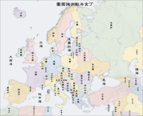
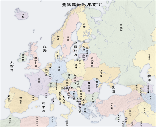
| Description |
English: Map of countries in Europe
Deutsch: Länder in Europa, Karte en
Français : pays en Europe, carte en
Español: países en Europa, mapa en
Български: Страните в Европа, карта с наименования на страните и столици на български език |
||||||||||
| Date | |||||||||||
| Source | own map, based on the Generic Mapping Tools and ETOPO2 | ||||||||||
| Author | San Jose (map), Itsmine (translation) | ||||||||||
| Permission (Reusing this file) |
|
||||||||||
| Other versions |
[]
|


See also
_en.png)
.png)
.jpg)
File history
Click on a date/time to view the file as it appeared at that time.
| Date/Time | Thumbnail | Dimensions | User | Comment | |
|---|---|---|---|---|---|
| current | 13:18, 20 May 2007 | | 1,475 × 1,200 (596 KB) | Itsmine (talk | contribs) | |
| 13:04, 20 May 2007 |  | 1,475 × 1,200 (596 KB) | Itsmine (talk | contribs) | ||
| 12:55, 20 May 2007 |  | 1,475 × 1,200 (596 KB) | Itsmine (talk | contribs) | ||
| 12:49, 20 May 2007 |  | 1,475 × 1,200 (596 KB) | Itsmine (talk | contribs) | ||
| 12:43, 20 May 2007 |  | 1,475 × 1,200 (596 KB) | Itsmine (talk | contribs) | ===English=== * Description: countries in Europe, map en * Source: own map, based on the [http://gmt.soest.hawaii.edu/ Generic Mapping Tools] and [http://dss.ucar.edu/datasets/ds759.3/ ETOPO2] * Author: San Jose, 2 April 2006 * Other ver |
You cannot overwrite this file.
File usage on Commons
The following 55 pages use this file:
- User:Itsmine
- File:Europan.png
- File:Europe countries map-zh-classical.png
- File:Europe countries map.png
- File:Europe countries map 2.png
- File:Europe countries map 2 hr.svg
- File:Europe countries map af.png
- File:Europe countries map ar 2.png
- File:Europe countries map bg.png
- File:Europe countries map bs.png
- File:Europe countries map ce.svg
- File:Europe countries map cs.png
- File:Europe countries map cs2.svg
- File:Europe countries map de.png
- File:Europe countries map de 2.png
- File:Europe countries map dsb.PNG
- File:Europe countries map en.png
- File:Europe countries map en 2.png
- File:Europe countries map eo.png
- File:Europe countries map es.png
- File:Europe countries map et.png
- File:Europe countries map fo.png
- File:Europe countries map fr.png
- File:Europe countries map fr 2.png
- File:Europe countries map gd.png
- File:Europe countries map got.png
- File:Europe countries map hsb.PNG
- File:Europe countries map hu.png
- File:Europe countries map it.png
- File:Europe countries map it 2.png
- File:Europe countries map ja.png
- File:Europe countries map ja 2.png
- File:Europe countries map km.png
- File:Europe countries map km 2.png
- File:Europe countries map la.png
- File:Europe countries map local lang.png
- File:Europe countries map local lang 2.png
- File:Europe countries map lt.png
- File:Europe countries map lv.png
- File:Europe countries map mn.png
- File:Europe countries map nah.png
- File:Europe countries map pl.png
- File:Europe countries map ru.png
- File:Europe countries map ru edited-1.png
- File:Europe countries map sk.png
- File:Europe countries map sl.png
- File:Europe countries map sq.png
- File:Europe countries map sr.png
- File:Europe countries map szl.png
- File:Europe countries map szl 2.png
- File:Europe countries map tg.png
- File:Europe countries map tr.png
- File:Europe countries map uk.png
- File:Europe countries map wo.PNG
- Template:Other versions/Europe countries map
File usage on other wikis
The following other wikis use this file:
- Usage on zh-classical.wikipedia.org