File:Europe in 1345.png
Jump to navigation
Jump to search

Size of this preview: 552 × 600 pixels. Other resolutions: 221 × 240 pixels | 442 × 480 pixels | 707 × 768 pixels | 1,075 × 1,168 pixels.
Original file (1,075 × 1,168 pixels, file size: 114 KB, MIME type: image/png)
Captions
Captions
Add a one-line explanation of what this file represents
Summary
[edit]
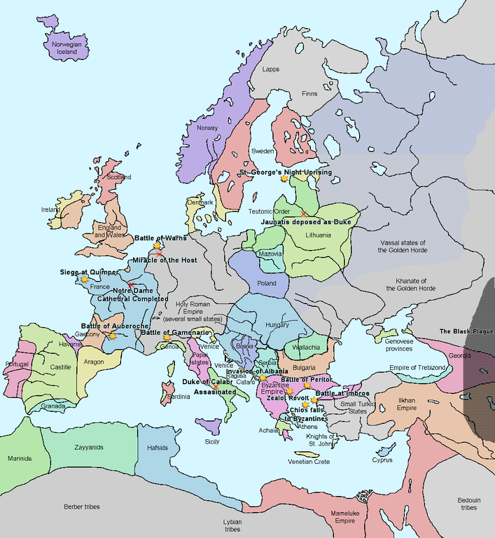
| Description | A map of Europe in 1345, showing the location of events that took place in that year. The Black Plague's exact location in unknown, and the shaded area to the right represents rough scholarly estimates. It hit the Crimea in the following year. |
| Date | |
| Source | self-made from Image:Europein1328.png with GIMP |
| Author | Teaandcrumpets |

|
This historical map image could be re-created using vector graphics as an SVG file. This has several advantages; see Commons:Media for cleanup for more information. If an SVG form of this image is available, please upload it and afterwards replace this template with
{{vector version available|new image name}}.
It is recommended to name the SVG file “Europe in 1345.svg”—then the template Vector version available (or Vva) does not need the new image name parameter. |
_en.png)
.png)
.jpg)
Licensing
[edit]
| I, the copyright holder of this work, release this work into the public domain. This applies worldwide. In some countries this may not be legally possible; if so: I grant anyone the right to use this work for any purpose, without any conditions, unless such conditions are required by law. |
File history
Click on a date/time to view the file as it appeared at that time.
| Date/Time | Thumbnail | Dimensions | User | Comment | |
|---|---|---|---|---|---|
| current | 19:31, 10 May 2020 | | 1,075 × 1,168 (114 KB) | Santasa99 (talk | contribs) | Corrections per Euroatlas - Historical Maps, http://www.euratlas.net/history/europe/1300/index.html Euratlas Periodis Web - Map of Europe in Year 1300 |
| 12:58, 24 December 2017 |  | 1,075 × 1,168 (289 KB) | Trey Kincaid (talk | contribs) | Changed Sicily who had his own kingdom | |
| 19:30, 1 July 2012 |  | 1,075 × 1,168 (282 KB) | Ludde23 (talk | contribs) | Changed Estonia from the red color of Sweden to the yellow color of Denmark, since Estonia was not Swedish at this time, but belonged to Denmark until 1346. | |
| 21:34, 24 April 2009 |  | 1,075 × 1,168 (112 KB) | Alex:D (talk | contribs) | Borders corrected | |
| 18:02, 15 November 2007 |  | 1,075 × 1,168 (110 KB) | Teaandcrumpets (talk | contribs) | (changed notre dame marker) | |
| 23:03, 13 November 2007 |  | 1,075 × 1,168 (113 KB) | Teaandcrumpets (talk | contribs) | {{Information |Description= A map of Europe in 1345, showing the location of events that took place in that year. |Source=self-made from Image:Europein1328.png with GIMP |Date= 13 Nov 2007 |Author= Teaandcrumpets |Permission= |
You cannot overwrite this file.
File usage on Commons
There are no pages that use this file.
File usage on other wikis
The following other wikis use this file:
- Usage on en.wikipedia.org
- Usage on fr.wikipedia.org
- Usage on sl.wikipedia.org
- Usage on smn.wikipedia.org
- Usage on ur.wikipedia.org