File:Extensió del valencià al País Valencià.svg
Jump to navigation
Jump to search

Size of this PNG preview of this SVG file: 424 × 600 pixels. Other resolutions: 170 × 240 pixels | 339 × 480 pixels | 543 × 768 pixels | 724 × 1,024 pixels | 1,448 × 2,048 pixels | 744 × 1,052 pixels.
Original file (SVG file, nominally 744 × 1,052 pixels, file size: 962 KB)
Captions
Captions
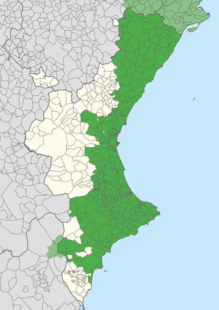
Extension of the Catalan language in the Land of Valencia
Summary
[edit]
| Description |
English: Extension of the Valencian language in the Valencian Community, according to Casanova and Sanchis Guarner.
Español: Extensión del Valenciano en la Comunidad Valenciana. |
| Map legend |
Català:
Zones valencianoparlants a la Comunitat Valenciana. Zones valencianoparlants fora de la Comunitat Valenciana. Zones castellanoparlants a la Comunitat Valenciana que eren valencianoparlants el principi del s. XX. English:
Valencian-speaking regions in the Valencian Community. Valencian-speaking regions outside the Valencian Community. Spanish-speaking regions in the Valencian Community that were Valencian-speaking at the beginning of the 20th century. Español: Zonas Valencianoparlantes en la Comunidad Valenciana. Zones Valencianoparlantes fuera de la Comunidad Valenciana. Zonas Castellanoparlantes en la Comunidad Valenciana que eran Valencianoparlantes al principio del siglo XX. |
| Date | |
| Source | Carche.map and OpenStreetMap. |
| Creator | |
| Geotemporal data | |
| Scale | 1:1,500,000 |
| Heading |
 |
| Georeferencing | If inappropriate please set warp_status = skip to hide. |
| Other versions |
Derivative works of this file: |
| SVG development | |
Licensing
[edit]
| This work contains information from OpenStreetMap, which is made available under the Open Database License (ODbL).
The ODbL does not require any particular license for maps produced from ODbL data. Prior to 1 August 2020, map tiles produced by the OpenStreetMap Foundation were licensed under the CC-BY-SA-2.0 license. Maps produced by other people may be subject to other licences. |
This file is licensed under the Creative Commons Attribution-Share Alike 2.5 Generic license.
Attribution: Joan M. Borràs (ebrenc)
- You are free:
- to share – to copy, distribute and transmit the work
- to remix – to adapt the work
- Under the following conditions:
- attribution – You must give appropriate credit, provide a link to the license, and indicate if changes were made. You may do so in any reasonable manner, but not in any way that suggests the licensor endorses you or your use.
- share alike – If you remix, transform, or build upon the material, you must distribute your contributions under the same or compatible license as the original.
File history
Click on a date/time to view the file as it appeared at that time.
| Date/Time | Thumbnail | Dimensions | User | Comment | |
|---|---|---|---|---|---|
| current | 11:27, 21 April 2020 | | 744 × 1,052 (962 KB) | FogueraC (talk | contribs) | voltants |
| 16:24, 20 April 2020 |  | 744 × 1,052 (881 KB) | FogueraC (talk | contribs) | standard colors | |
| 01:12, 18 May 2007 |  | 725 × 1,244 (1.53 MB) | Ebrenc (talk | contribs) | {{Cc-by-sa-2.5|Joan M. Borràs (ebrenc)}} Category:Maps of the Land of Valencia Category:Catalan language |
You cannot overwrite this file.
File usage on Commons
The following 2 pages use this file:
File usage on other wikis
The following other wikis use this file:
- Usage on ar.wikipedia.org
- Usage on ast.wikipedia.org
- Usage on ca.wikipedia.org
- Usage on co.wikipedia.org
- Usage on cs.wikipedia.org
- Usage on de.wikipedia.org
- Usage on en.wikipedia.org
- Usage on es.wikipedia.org
- Comunidad Valenciana
- Discusión:Idiomas de España
- Vega Baja del Segura
- Predominio lingüístico
- Ley de uso y enseñanza del valenciano
- Portal:Comunidad Valenciana
- Idioma valenciano
- Usuario:Castellónenred/Página de Pruebas/PortalCV/Cultura y Tradiciones
- Portal:Comunidad Valenciana/Cultura y Tradiciones
- Cultura de la Comunidad Valenciana
- Usuario:MetroVal/Valenciano
- Usuario:JuananMJ/Taller
- Usage on es.wikivoyage.org
- Usage on eu.wikipedia.org
- Usage on ext.wikipedia.org
- Usage on fi.wikipedia.org
- Usage on fr.wikipedia.org
- Usage on gl.wikipedia.org
- Usage on he.wikipedia.org
- Usage on ia.wikipedia.org
- Usage on id.wikipedia.org
- Usage on ie.wikipedia.org
- Usage on it.wikipedia.org
- Usage on ja.wikipedia.org
View more global usage of this file.