File:Falkland Islands topographic map-ar.svg
Jump to navigation
Jump to search

Size of this PNG preview of this SVG file: 768 × 599 pixels. Other resolutions: 308 × 240 pixels | 615 × 480 pixels | 984 × 768 pixels | 1,280 × 999 pixels | 2,560 × 1,998 pixels | 2,550 × 1,990 pixels.
Original file (SVG file, nominally 2,550 × 1,990 pixels, file size: 1.94 MB)
Captions
Captions
Add a one-line explanation of what this file represents
Summary
[edit]
| Description |
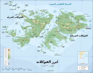
العربية: جُزر الفوكلاند هي أرخبيلٌ من الجُزر الواقعة في المُحيط الأطلسي الجنوبي، على بُعد 300 ميل عن ساحل الأرجنتين. تتكوَّن من جزيرتين أساسيتين، الفوكلاند الشرقيَّة والفوكلاند الغربيَّة، ومعها حوالي 700 جزيرة أُخرى أصغر حجمًا. عاصمتها هي مدينة ستانلي، الواقعة على الفوكلاند الشرقيَّة، وهي كذلك أكبر مُدنها وأعظمها شأنًا. هذه الجُزر تدخل ضمن نطاق أقاليم ما وراء البحار البريطانيَّة، وبالتالي فهي تتبع بريطانيا رُغم أنها تتمتع بالحُكم الذاتي. |
| Date | |
| Source | Derivative from this file |
| Author |
| This is a retouched picture, which means that it has been digitally altered from its original version. Modifications: Translated to Arabic - عُرِّبت. The original can be viewed here: Falkland Islands topographic map-en.svg:
|
This SVG map uses required raster graphics to show delicate structures.
Licensing
[edit]
I, the copyright holder of this work, hereby publish it under the following licenses:

|
Permission is granted to copy, distribute and/or modify this document under the terms of the GNU Free Documentation License, Version 1.2 or any later version published by the Free Software Foundation; with no Invariant Sections, no Front-Cover Texts, and no Back-Cover Texts. A copy of the license is included in the section entitled GNU Free Documentation License. |
| This file is licensed under the Creative Commons Attribution-Share Alike 3.0 Unported license. | ||
| ||
| This licensing tag was added to this file as part of the GFDL licensing update. |
This file is licensed under the Creative Commons Attribution-Share Alike 2.5 Generic, 2.0 Generic and 1.0 Generic license.
- You are free:
- to share – to copy, distribute and transmit the work
- to remix – to adapt the work
- Under the following conditions:
- attribution – You must give appropriate credit, provide a link to the license, and indicate if changes were made. You may do so in any reasonable manner, but not in any way that suggests the licensor endorses you or your use.
- share alike – If you remix, transform, or build upon the material, you must distribute your contributions under the same or compatible license as the original.
You may select the license of your choice.
File history
Click on a date/time to view the file as it appeared at that time.
| Date/Time | Thumbnail | Dimensions | User | Comment | |
|---|---|---|---|---|---|
| current | 13:54, 24 October 2015 | | 2,550 × 1,990 (1.94 MB) | باسم (talk | contribs) | Organized Text - تصحيح النص |
| 13:51, 24 October 2015 |  | 2,550 × 1,990 (1.94 MB) | باسم (talk | contribs) | Organized Text - ترتيب النص | |
| 13:44, 24 October 2015 |  | 2,550 × 1,990 (1.94 MB) | باسم (talk | contribs) | User created page with UploadWizard |
You cannot overwrite this file.
File usage on Commons
The following 25 pages use this file:
- User:4ing/Falkland Islands/2015-10
- Commons:WikiProject Aviation/recent uploads/2015 October 24
- File:Falkland Islands map shaded relief-en.svg
- File:Falkland Islands map shaded relief-fr.svg
- File:Falkland Islands topographic map-ca.svg
- File:Falkland Islands topographic map-da.svg
- File:Falkland Islands topographic map-de.svg
- File:Falkland Islands topographic map-en.svg
- File:Falkland Islands topographic map-en librsvg.png
- File:Falkland Islands topographic map-en rendersvg.png
- File:Falkland Islands topographic map-es.svg
- File:Falkland Islands topographic map-es (argentinian names places).svg
- File:Falkland Islands topographic map-fr.svg
- File:Falkland Islands topographic map-it.svg
- File:Falkland Islands topographic map-ka.svg
- File:Falkland Islands topographic map-mk.svg
- File:Falkland Islands topographic map-nb.svg
- File:Falkland Islands topographic map-nl.svg
- File:Falkland Islands topographic map-nn.svg
- File:Falkland Islands topographic map-pl.svg
- File:Falkland Islands topographic map-pt (argentinian names places).svg
- File:Falkland Islands topographic map-ru.svg
- File:Falkland Islands topographic map-sr.svg
- File:Falkland Islands topographic map-zh-hans.svg
- Template:Other versions/Falkland Islands topographic map
.svg)
.svg)
File usage on other wikis
The following other wikis use this file: