File:Falkland Islands topographic map-zh-hans.svg
Jump to navigation
Jump to search

Size of this PNG preview of this SVG file: 768 × 599 pixels. Other resolutions: 308 × 240 pixels | 615 × 480 pixels | 984 × 768 pixels | 1,280 × 999 pixels | 2,560 × 1,998 pixels | 2,550 × 1,990 pixels.
Original file (SVG file, nominally 2,550 × 1,990 pixels, file size: 1.77 MB)
Captions
Captions
Add a one-line explanation of what this file represents

Summary
[edit]| Description |
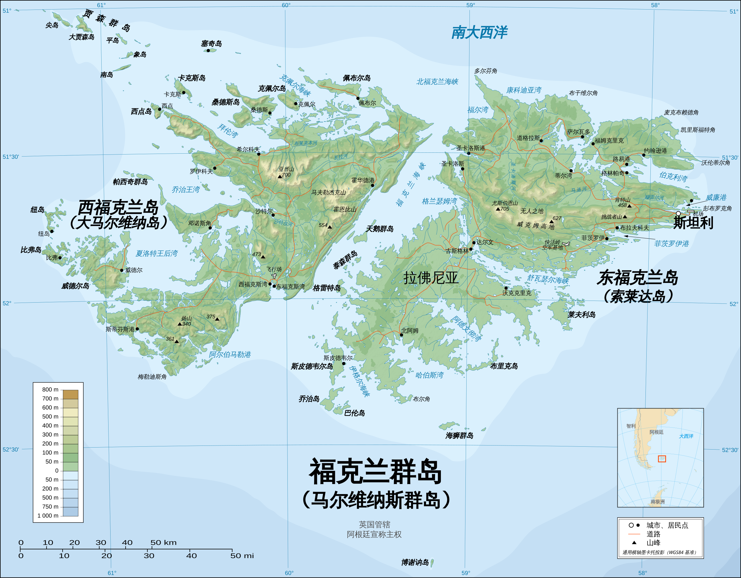
English: The Falkland Islands are an archipelago in the South Atlantic Ocean, located 300 miles off the coast of Argentina. They consist of two main islands, East Falkland and West Falkland, together with about 700 smaller islands. Stanley, on East Falkland, is the capital and largest city. The islands are a self-governing Overseas Territory of the United Kingdom. 中文(中国大陆):福克兰群岛位于南大西洋,距阿根廷海岸300英里。群岛由东福克兰岛和西福克兰岛两个主要岛屿以及700多个小岛组成。东福克兰岛上的斯坦利是其首都及最大城市。群岛是英国的海外自治领土。 |
| Date | (English version); 2014-08-02 (Chinese translation) |
| Source | Chinese translation of File:Falkland Islands topographic map-en.svg. |
| Author | Eric Gaba (English version); SSYoung (Chinese translation) |
| Other versions |
[]
|


.svg)


.svg)


|
This SVG file contains embedded text that can be translated into your language, using any capable SVG editor, text editor or the SVG Translate tool. For more information see: About translating SVG files. |
Licensing
[edit]
I, the copyright holder of this work, hereby publish it under the following licenses:

|
Permission is granted to copy, distribute and/or modify this document under the terms of the GNU Free Documentation License, Version 1.2 or any later version published by the Free Software Foundation; with no Invariant Sections, no Front-Cover Texts, and no Back-Cover Texts. A copy of the license is included in the section entitled GNU Free Documentation License. |
| This file is licensed under the Creative Commons Attribution-Share Alike 3.0 Unported license. | ||
| ||
| This licensing tag was added to this file as part of the GFDL licensing update. |
This file is licensed under the Creative Commons Attribution-Share Alike 2.5 Generic, 2.0 Generic and 1.0 Generic license.
- You are free:
- to share – to copy, distribute and transmit the work
- to remix – to adapt the work
- Under the following conditions:
- attribution – You must give appropriate credit, provide a link to the license, and indicate if changes were made. You may do so in any reasonable manner, but not in any way that suggests the licensor endorses you or your use.
- share alike – If you remix, transform, or build upon the material, you must distribute your contributions under the same or compatible license as the original.
You may select the license of your choice.
File history
Click on a date/time to view the file as it appeared at that time.
| Date/Time | Thumbnail | Dimensions | User | Comment | |
|---|---|---|---|---|---|
| current | 15:35, 8 August 2014 | | 2,550 × 1,990 (1.77 MB) | SSYoung (talk | contribs) | adding Spanish island names |
| 14:54, 3 August 2014 |  | 2,550 × 1,990 (1.77 MB) | SSYoung (talk | contribs) | minor fix | |
| 14:45, 3 August 2014 |  | 2,550 × 1,990 (1.77 MB) | SSYoung (talk | contribs) | Reverted to version as of 13:49, 3 August 2014 | |
| 14:44, 3 August 2014 |  | 2,550 × 1,990 (1.79 MB) | SSYoung (talk | contribs) | minor fix | |
| 14:33, 3 August 2014 |  | 2,550 × 1,990 (1.79 MB) | SSYoung (talk | contribs) | minor fix | |
| 13:49, 3 August 2014 |  | 2,550 × 1,990 (1.77 MB) | SSYoung (talk | contribs) | User created page with UploadWizard |
You cannot overwrite this file.
File usage on Commons
The following 24 pages use this file:
- User:4ing/Falkland Islands/2014-08
- File:Falkland Islands map shaded relief-en.svg
- File:Falkland Islands map shaded relief-fr.svg
- File:Falkland Islands topographic map-ca.svg
- File:Falkland Islands topographic map-da.svg
- File:Falkland Islands topographic map-de.svg
- File:Falkland Islands topographic map-en.svg
- File:Falkland Islands topographic map-en librsvg.png
- File:Falkland Islands topographic map-en rendersvg.png
- File:Falkland Islands topographic map-es.svg
- File:Falkland Islands topographic map-es (argentinian names places).svg
- File:Falkland Islands topographic map-fr.svg
- File:Falkland Islands topographic map-it.svg
- File:Falkland Islands topographic map-ka.svg
- File:Falkland Islands topographic map-mk.svg
- File:Falkland Islands topographic map-nb.svg
- File:Falkland Islands topographic map-nl.svg
- File:Falkland Islands topographic map-nn.svg
- File:Falkland Islands topographic map-pl.svg
- File:Falkland Islands topographic map-pt (argentinian names places).svg
- File:Falkland Islands topographic map-ru.svg
- File:Falkland Islands topographic map-sr.svg
- File:Falkland Islands topographic map-zh-hans.svg
- Template:Other versions/Falkland Islands topographic map
File usage on other wikis
The following other wikis use this file:
- Usage on zh.wikipedia.org
- 福克兰群岛
- 福克兰群岛地理
- 喬治王灣 (福克蘭群島)
- Wikipedia:优良条目/2014年10月
- Wikipedia:典范条目/2014年8月
- Wikipedia:优良条目/2014年10月18日
- Wikipedia:优良条目/福克兰群岛
- Wikipedia:典范条目/2014年8月15日
- Wikipedia:典范条目/福克兰群岛
- Wikipedia:典范条目/2016年9月
- Wikipedia:典范条目/2016年9月30日
- Wikipedia:特色圖片評選/福克蘭群島
- Wikipedia:特色圖片評選/存檔/2017年5月
- Wikipedia:典范条目/2019年2月
- Wikipedia:典范条目/2019年2月1日
- Wikipedia:典范条目/2022年11月
- Wikipedia:典范条目/2022年11月26日