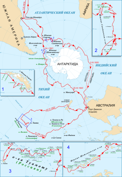
File:First Russian Antarctic Expedition route - ru.svg
From Wikimedia Commons, the free media repository
Jump to navigation
Jump to search

Size of this PNG preview of this SVG file: 414 × 599 pixels. Other resolutions: 166 × 240 pixels | 332 × 480 pixels | 531 × 768 pixels | 708 × 1,024 pixels | 1,416 × 2,048 pixels | 1,451 × 2,098 pixels.
Original file (SVG file, nominally 1,451 × 2,098 pixels, file size: 1.67 MB)
File information
Structured data
Captions
Captions
Add a one-line explanation of what this file represents
Summary
[edit]| DescriptionFirst Russian Antarctic Expedition route - ru.svg |
Русский: Маршрут первой руссой антарктической экспедиции Беллинсгаузена и Лазарева в 1819—1821 годах. Български: Маршрутът на първата руска антарктическа експедиция на Белингсхаузен и Лазарев през 1819 – 1821 г. |
||
| Date | |||
| Source |
 Map: |
||
| Author | Kaidor | ||
| SVG development InfoField |
|
Licensing
[edit]I, the copyright holder of this work, hereby publish it under the following license:
This file is licensed under the Creative Commons Attribution-Share Alike 4.0 International license.
- You are free:
- to share – to copy, distribute and transmit the work
- to remix – to adapt the work
- Under the following conditions:
- attribution – You must give appropriate credit, provide a link to the license, and indicate if changes were made. You may do so in any reasonable manner, but not in any way that suggests the licensor endorses you or your use.
- share alike – If you remix, transform, or build upon the material, you must distribute your contributions under the same or compatible license as the original.
File history
Click on a date/time to view the file as it appeared at that time.
| Date/Time | Thumbnail | Dimensions | User | Comment | |
|---|---|---|---|---|---|
| current | 14:35, 21 April 2019 |  | 1,451 × 2,098 (1.67 MB) | Kaidor (talk | contribs) | Геогрия → Георгия |
| 14:26, 15 April 2019 |  | 1,451 × 2,098 (1.67 MB) | Kaidor (talk | contribs) | User created page with UploadWizard |
You cannot overwrite this file.
File usage on Commons
The following 8 pages use this file:
- User:4ing/Antarctica/2019-01-06
- User:Chumwa/OgreBot/Potential transport maps/2019 April 11-20
- User:Chumwa/OgreBot/Transport Maps/2019 April 11-20
- User:Chumwa/OgreBot/Travel and communication maps/2019 April 11-20
- User:Kaidor
- User:OgreBot/Watercraft/2019 April 15
- User:OgreBot/Watercraft/2019 April 21
- File:First Russian Antarctic Expedition route - fr.svg
File usage on other wikis
The following other wikis use this file:
- Usage on fr.wikipedia.org
- Usage on ru.wikipedia.org
- Usage on uk.wikipedia.org
Metadata
This file contains additional information such as Exif metadata which may have been added by the digital camera, scanner, or software program used to create or digitize it. If the file has been modified from its original state, some details such as the timestamp may not fully reflect those of the original file. The timestamp is only as accurate as the clock in the camera, and it may be completely wrong.
| Width | 1451.0463 |
|---|---|
| Height | 2098.4321 |
Categories:
- Maps of the exploration of Antarctica
- Expedition maps
- Maps of voyages
- SVG maps of Antarctica
- SVG maps of the Tuamotus
- Fabian Gottlieb von Bellingshausen
- Mikhail Petrovich Lazarev
- Natural Earth
- Russian-language maps of Antarctica
- Russian-language SVG maps showing history
- Russian language maps of the Pacific Ocean