File:Flag of River Gee County.svg
Jump to navigation
Jump to search

Size of this PNG preview of this SVG file: 512 × 341 pixels. Other resolutions: 320 × 213 pixels | 640 × 426 pixels | 1,024 × 682 pixels | 1,280 × 853 pixels | 2,560 × 1,705 pixels.
Original file (SVG file, nominally 512 × 341 pixels, file size: 45 KB)
Captions
Captions
Add a one-line explanation of what this file represents
Summary
[edit]
| Description |
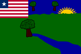
English: Flag of the Liberian county of River Gee. |
| Date | 2000 |
| Source | Own work |
| Author | The Macaroni Man |
Licensing
[edit]
I, the copyright holder of this work, hereby publish it under the following license:
This file is licensed under the Creative Commons Attribution-Share Alike 3.0 Unported license.
- You are free:
- to share – to copy, distribute and transmit the work
- to remix – to adapt the work
- Under the following conditions:
- attribution – You must give appropriate credit, provide a link to the license, and indicate if changes were made. You may do so in any reasonable manner, but not in any way that suggests the licensor endorses you or your use.
- share alike – If you remix, transform, or build upon the material, you must distribute your contributions under the same or compatible license as the original.
File history
Click on a date/time to view the file as it appeared at that time.
| Date/Time | Thumbnail | Dimensions | User | Comment | |
|---|---|---|---|---|---|
| current | 12:50, 26 December 2017 | | 512 × 341 (45 KB) | The Macaroni Man (talk | contribs) | Adjusted nodes around edges. |
| 10:08, 26 December 2017 |  | 512 × 341 (45 KB) | The Macaroni Man (talk | contribs) | Redrawn; the previous version is inaccurate to the flag as it appears in real life. Drawn with Flags of the World's version as reference, in turn drawn from a series of Liberian stamps showing the county flags. | |
| 22:34, 23 March 2013 |  | 2,700 × 1,800 (10 KB) | NikNaks (talk | contribs) | Adding missing elements | |
| 16:32, 21 March 2013 |  | 2,700 × 1,800 (6 KB) | Fry1989 (talk | contribs) | User created page with UploadWizard |
You cannot overwrite this file.
File usage on Commons
The following 6 pages use this file:
File usage on other wikis
The following other wikis use this file:
- Usage on ar.wikipedia.org
- Usage on be.wikipedia.org
- Usage on bg.wikipedia.org
- Usage on br.wikipedia.org
- Usage on ca.wikipedia.org
- Usage on ceb.wikipedia.org
- Usage on cs.wikipedia.org
- Usage on cy.wikipedia.org
- Usage on de.wikipedia.org
- Usage on el.wikipedia.org
- Usage on en.wikipedia.org
- Liberia
- Politics of Liberia
- Flag of Liberia
- Counties of Liberia
- Canton (flag)
- River Gee County
- Flags of Africa
- List of political and geographic subdivisions by total area from 5,000 to 20,000 square kilometers
- List of political and geographic subdivisions by total area (all)
- List of political and geographic subdivisions by total area from 5,000 to 7,000 square kilometers
- Administrative divisions of Liberia
- User:TolleWurst/Flags of countries and country subdivisions
- List of Liberian counties by Human Development Index
- User:Ilovecrabcakes1462
- List of Liberian flags
- Draft:List of country subdivision flags in Africa
- Usage on es.wikipedia.org
- Usage on eu.wikipedia.org
- Usage on fa.wikipedia.org
- Usage on fi.wikipedia.org
- Usage on fr.wikipedia.org
- Usage on hy.wikipedia.org
- Usage on id.wikipedia.org
- Usage on ig.wikipedia.org
- Usage on is.wikipedia.org
- Usage on it.wikipedia.org
- Usage on ja.wikipedia.org
View more global usage of this file.