File:Flood comparison.jpg
Jump to navigation
Jump to search

Size of this preview: 800 × 267 pixels. Other resolutions: 320 × 107 pixels | 640 × 213 pixels | 1,024 × 341 pixels | 1,280 × 427 pixels | 3,200 × 1,067 pixels.
Original file (3,200 × 1,067 pixels, file size: 1.17 MB, MIME type: image/jpeg)
Captions
Captions
Add a one-line explanation of what this file represents
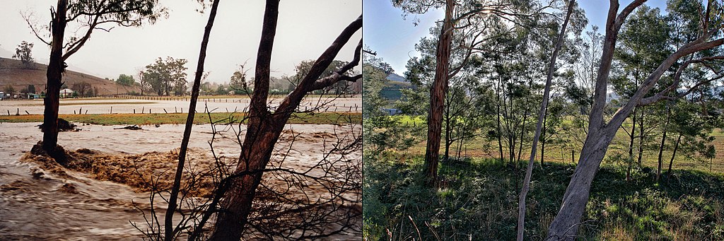
The photo on the left shows the Swifts Creek during the 1998 floods. The image on the right shows the same location on 2006 - 8 years later.
I, the copyright holder of this work, hereby publish it under the following license:
| ||||||||
Taken or created by Fir0002
|

| Camera location | | View this and other nearby images on: OpenStreetMap |
|---|
File history
Click on a date/time to view the file as it appeared at that time.
| Date/Time | Thumbnail | Dimensions | User | Comment | |
|---|---|---|---|---|---|
| current | 12:53, 26 June 2006 | 3,200 × 1,067 (1.17 MB) | Fir0002 (talk | contribs) | The photo on the left shows the Swifts Creek during the 1998 floods. The image on the right shows the same location on 2006 - 8 years later. {{Fir0002}} |
You cannot overwrite this file.
File usage on Commons
The following 2 pages use this file:
File usage on other wikis
The following other wikis use this file:
- Usage on ar.wikipedia.org
- Usage on en.wikipedia.org
- Usage on it.wikipedia.org
- Usage on ps.wikipedia.org