File:Freedom of Panorama world map.png
Jump to navigation
Jump to search
Size of this preview: 800 × 352 pixels. Other resolutions: 320 × 141 pixels | 640 × 282 pixels | 1,427 × 628 pixels.
Original file (1,427 × 628 pixels, file size: 56 KB, MIME type: image/png)
Captions
Captions
Add a one-line explanation of what this file represents
Summary
[edit]| Description |
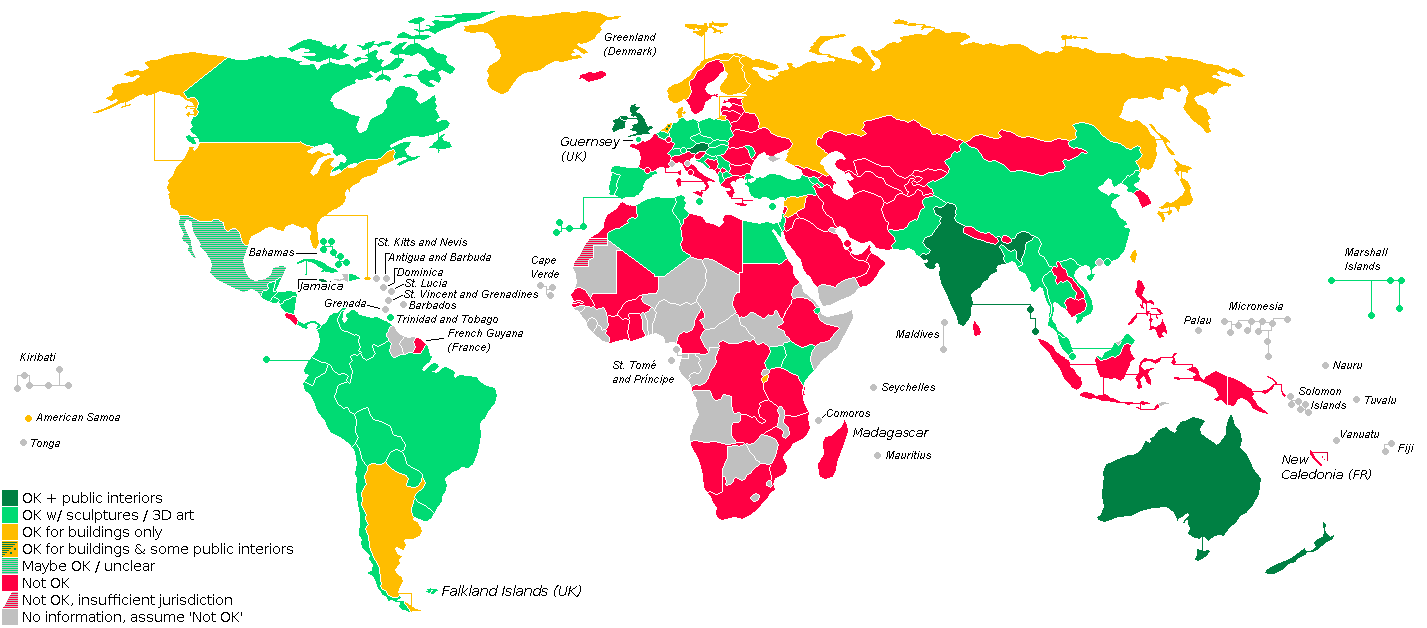
Freedom of Panorama (FOP) world map. OK, including public interiors
OK, with permanently placed sculptures / 3D art
OK for buildings only
OK for buildings and some public interiours
Maybe OK / unclear
Not OK
Not OK, insufficient jurisdiction
No information, assume 'Not OK'
Non-commercial use of photos of buildings is not specified in this image. The map is incomplete due to lack of information on several countries' copyright legislation.
|
| Date | |
| Source | Based on relatively blank and simplified World Map blank (island names).PNG, made by User:MapLoader. |
| Author | Mardus |
| Other versions |
|
.PNG)

|
File:Freedom of Panorama world map.svg is a vector version of this file. It should be used in place of this PNG file when not inferior.
File:Freedom of Panorama world map.png → File:Freedom of Panorama world map.svg
For more information, see Help:SVG. |
 |
Licensing
[edit]
This file is licensed under the Creative Commons Attribution-Share Alike 3.0 Unported license.
- You are free:
- to share – to copy, distribute and transmit the work
- to remix – to adapt the work
- Under the following conditions:
- attribution – You must give appropriate credit, provide a link to the license, and indicate if changes were made. You may do so in any reasonable manner, but not in any way that suggests the licensor endorses you or your use.
- share alike – If you remix, transform, or build upon the material, you must distribute your contributions under the same or compatible license as the original.
File history
Click on a date/time to view the file as it appeared at that time.
| Date/Time | Thumbnail | Dimensions | User | Comment | |
|---|---|---|---|---|---|
| current | 07:26, 22 May 2021 | | 1,427 × 628 (56 KB) | Michalg95 (talk | contribs) | w Albanii jest już wolność panoramy |
| 20:42, 4 January 2017 |  | 1,427 × 628 (28 KB) | Flamenc (talk | contribs) | Belgium is green since July 15th 2016 [http://www.ejustice.just.fgov.be/cgi/article_body.pl?language=nl&caller=summary&pub_date=2016-07-05&numac=2016011277 27 JUNI 2016. - Wet tot wijziging van het Wetboek van economisch recht met het oog op de invoeri... | |
| 17:09, 17 May 2016 |  | 1,427 × 628 (25 KB) | Mardus (talk | contribs) | Sweden is red per Swedish Supreme Court decision. Visibility: Legend for countries with mixed rules, like Belgium, changed, along with Belgium itself. | |
| 18:46, 4 November 2014 |  | 1,427 × 628 (22 KB) | Palosirkka (talk | contribs) | to indexed colors; lossless compress | |
| 19:13, 1 October 2014 |  | 1,427 × 628 (50 KB) | A.Savin (talk | contribs) | Crimea unknown | |
| 05:48, 1 October 2014 |  | 1,427 × 628 (53 KB) | MBH (talk | contribs) | updated russia - fop for buildings | |
| 06:26, 31 August 2014 |  | 1,427 × 628 (47 KB) | Mardus (talk | contribs) | Minor adjustments. | |
| 06:15, 31 August 2014 |  | 1,427 × 628 (47 KB) | Mardus (talk | contribs) | Jamaica is OK, closely follows UK copyright law. Moved Caribbena island names around to allow for 'Jamaica'. | |
| 05:20, 13 April 2014 |  | 1,427 × 628 (46 KB) | Mardus (talk | contribs) | Papua New Guinea not OK. | |
| 23:55, 12 April 2014 |  | 1,427 × 628 (46 KB) | Mardus (talk | contribs) | Oman not OK. |
You cannot overwrite this file.
File usage on Commons
The following 17 pages use this file:
- Freedom of Panorama ZM
- User:4ing/Antarctica/2014-04
- User:Magog the Ogre/Multilingual legend/2021 May 21-31
- User:Mardus/Favorites
- User:Mardus/Gallery
- User:Minorax/SVG available/2021 May 19-24
- Commons:Graphic Lab/Map workshop/Archive/2016
- Commons:Graphic Lab/Map workshop/Archive/2020
- Commons talk:Freedom of panorama/Archive 17
- File:Freedom of Panorama world map.svg
- File:Freedom of Panorama world map fr.svg
- File:Freedom of Panorama world map ja.svg
- File:Freedom of Panorama world map uz.svg
- File:Freedom of Panorama world map zh.svg
- File:Freedom of panorama map.jpg
- File:Wikimedia ZA submission to the Parliementory comittee on Trade and Industry - 7 July 2017.pdf
- Template:Other versions/Freedom of Panorama world map
File usage on other wikis
The following other wikis use this file:
- Usage on af.wikipedia.org
- Usage on ca.wikipedia.org
- Usage on de.wikipedia.org
- Usage on el.wikipedia.org
- Usage on en.wikipedia.org
- Usage on eo.wikipedia.org
- Usage on es.wikipedia.org
- Usage on fa.wikipedia.org
- Usage on fa.wikibooks.org
- Usage on fa.wikivoyage.org
- Usage on fr.wikipedia.org
- Usage on lt.wikipedia.org
- Usage on pl.wikipedia.org
- Usage on ro.wikipedia.org
- Usage on sq.wikipedia.org
- Usage on sr.wikipedia.org
- Usage on te.wikipedia.org
- Usage on uk.wikipedia.org