File:Frieden von Nystad, Stockholm und Fredericksborg.svg
From Wikimedia Commons, the free media repository
Jump to navigation
Jump to search

Size of this PNG preview of this SVG file: 724 × 599 pixels. Other resolutions: 290 × 240 pixels | 580 × 480 pixels | 928 × 768 pixels | 1,237 × 1,024 pixels | 2,474 × 2,048 pixels | 1,127 × 933 pixels.
Original file (SVG file, nominally 1,127 × 933 pixels, file size: 684 KB)
File information
Structured data
Captions
Captions
Add a one-line explanation of what this file represents
Summary
[edit]| DescriptionFrieden von Nystad, Stockholm und Fredericksborg.svg |
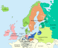
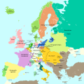
Deutsch: Eine einfache Karte von Europa am Ende des Großen Nordischen Kriegs mit den territorialen Änderungen in den Friedensverträgen von Stockholm (1719/1720), Fredericksborg (1720) und Nystad (1721):
English: A simple map showing Europe at the end of the Great Nordic War, 1721, with the territorial changes according to the Peace Treaties of Stockholm (1719/1720), Frederikcksborg (1720) and Nystad (1721)
|
||
| Date | |||
| Source |
This file was derived from: Blank map of Europe 1714.svg |
||
| Author |
|
||
| Permission (Reusing this file) |
I, the copyright holder of this work, hereby publish it under the following licenses:
This file is licensed under the Creative Commons Attribution-Share Alike 4.0 International license.
You may select the license of your choice. |
||
| Other versions |
|
||
| SVG development InfoField | This vector image was created with Adobe Illustrator. |
File history
Click on a date/time to view the file as it appeared at that time.
| Date/Time | Thumbnail | Dimensions | User | Comment | |
|---|---|---|---|---|---|
| current | 11:29, 20 October 2016 |  | 1,127 × 933 (684 KB) | Furfur (talk | contribs) | Details (Grenze in Karelien) |
| 22:11, 16 October 2016 |  | 1,127 × 933 (682 KB) | Furfur (talk | contribs) | Teile Holsteins und Grafschaft Oldenburg auch unter dänischer Herrschaft | |
| 19:53, 1 October 2016 |  | 1,127 × 933 (682 KB) | Furfur (talk | contribs) | hellere Meeresfarbe | |
| 16:39, 1 October 2016 |  | 1,127 × 933 (681 KB) | Furfur (talk | contribs) | Schasen-Polen entfärbt, waren keine Vertragspartner | |
| 16:23, 1 October 2016 |  | 1,127 × 933 (681 KB) | Furfur (talk | contribs) | Korrektur | |
| 16:16, 1 October 2016 |  | 1,127 × 933 (682 KB) | Furfur (talk | contribs) | Detialkorrekturen | |
| 16:11, 1 October 2016 |  | 1,127 × 933 (682 KB) | Furfur (talk | contribs) | == {{int:filedesc}} == {{Information |Description={{User:Medium69/Traduction}} {{de|1=Eine einfache Karte von Europa am Ende des Großen Nordischen Kriegs mit den territorialen Änderungen in den Friedensverträgen von Stockholm (1719/1720), Fredericks... |
You cannot overwrite this file.
File usage on Commons
The following 2 pages use this file:
File usage on other wikis
The following other wikis use this file:
- Usage on cs.wikipedia.org
- Usage on de.wikipedia.org
- Usage on hu.wikipedia.org
- Usage on nl.wikipedia.org
- Usage on sl.wikipedia.org
Metadata
This file contains additional information such as Exif metadata which may have been added by the digital camera, scanner, or software program used to create or digitize it. If the file has been modified from its original state, some details such as the timestamp may not fully reflect those of the original file. The timestamp is only as accurate as the clock in the camera, and it may be completely wrong.
| Width | 1127.363px |
|---|---|
| Height | 933.104px |


