File:Gallia Cisalpina-fr.svg
Jump to navigation
Jump to search

Size of this PNG preview of this SVG file: 794 × 600 pixels. Other resolutions: 318 × 240 pixels | 635 × 480 pixels | 1,017 × 768 pixels | 1,280 × 967 pixels | 2,560 × 1,934 pixels | 949 × 717 pixels.
Original file (SVG file, nominally 949 × 717 pixels, file size: 822 KB)
Captions
Captions
Add a one-line explanation of what this file represents
Summary
[edit]| Description |
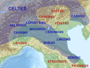
English: Map of Cisalpine Gaul.
Français : Carte de la Gaule cisalpine et de l'emplacement approximatif des peuples qui l'habitaient et des peuples voisins.
Italiano: Distribuzione approssimata delle popolazioni della Gallia Cisalpina.
|
||||
| Date | |||||
| Source |
This file was derived from: |
||||
| Author |
|
||||
| Other versions |
[]
| ||||
| Attribution (required by the license) | © Sémhur / Wikimedia Commons / | ||||
| SVG | W3C-validity not checked.
|
||||
| Graphic Lab |


| Camera location | | View this and other nearby images on: OpenStreetMap |
|---|
Licensing
[edit]
I, the copyright holder of this work, hereby publish it under the following licenses:
| Copyleft: This work of art is free; you can redistribute it and/or modify it according to terms of the Free Art License. You will find a specimen of this license on the Copyleft Attitude site as well as on other sites. |
This file is licensed under the Creative Commons Attribution-Share Alike 4.0 International, 3.0 Unported, 2.5 Generic, 2.0 Generic and 1.0 Generic license.
- You are free:
- to share – to copy, distribute and transmit the work
- to remix – to adapt the work
- Under the following conditions:
- attribution – You must give appropriate credit, provide a link to the license, and indicate if changes were made. You may do so in any reasonable manner, but not in any way that suggests the licensor endorses you or your use.
- share alike – If you remix, transform, or build upon the material, you must distribute your contributions under the same or compatible license as the original.
You may select the license of your choice.
Original upload log
[edit]
This image is a derivative work of the following images:
- File:Gallia_cisalpina.jpg licensed with GFDL, GFDL-user-w
- 2010-05-22T09:04:55Z GaiusCrastinus 732x550 (473321 Bytes) {{Information |Description=Map of Cisalpine Gaul |Source=[http://it.wikipedia.org/wiki/File:Gallia_cisalpina.jpg] |Date= |Author=Xoil |Permission= |other_versions= }} {{GFDL-user-w|projectcode|Wikipedia|Xoil}} [[Category:M
- File:Italy_topographic_map-ancient_Roman_roads.svg licensed with Cc-by-sa-3.0, GFDL
- 2012-06-27T17:17:18Z Flappiefh 1587x1833 (1830617 Bytes) Réduction de la surface affichée pour se concentrer sur le territoire de l'Italie.
- 2012-06-27T14:58:16Z Flappiefh 1759x2167 (1829252 Bytes) {{Information |Description ={{fr|1=Carte topographique représentant les principales voies romaines construites en Italie sous l'Empire Romain.}} |Source =Based on a [[:File:Italy topographic map-blank.svg|Topograp
Uploaded with derivativeFX
File history
Click on a date/time to view the file as it appeared at that time.
| Date/Time | Thumbnail | Dimensions | User | Comment | |
|---|---|---|---|---|---|
| current | 20:56, 31 August 2013 | | 949 × 717 (822 KB) | Sémhur (talk | contribs) | == {{int:filedesc}} == {{Information |Description={{Multilingual description/start}} {{en|1= Map of Cisalpine Gaul.}} {{fr|1= Carte de la fr:Gaule cisalpine et de l'emplacement approximatif des peuples qui l'habitaient et des peuples voisins.}} {... |
You cannot overwrite this file.
File usage on Commons
The following 6 pages use this file:
File usage on other wikis
The following other wikis use this file:
- Usage on af.wikipedia.org
- Usage on bg.wikipedia.org
- Usage on br.wikipedia.org
- Usage on ca.wikipedia.org
- Usage on el.wikipedia.org
- Usage on en.wikipedia.org
- Usage on et.wikipedia.org
- Usage on eu.wikipedia.org
- Usage on fa.wikipedia.org
- Usage on fr.wikipedia.org
- Sénons
- Liste des peuples celtes
- Lingons
- Gaule cisalpine
- Celtes d'Italie
- Marcus Claudius Marcellus (consul en -222)
- Senigallia
- Raids gaulois en Italie
- Tombe à char du monde celtique
- Caius Cornelius Cethegus (consul en -197)
- Culture de Golasecca
- Wikipédia:Atelier graphique/Cartes/Archives/septembre 2013
- Tombe de Ca' Morta
- Modèle:Palette Culture de Golasecca
- Mediolanum
- Inscription de Prestino
- Tombe du deuxième guerrier de Sesto Callende
- Utilisateur:Ruyblas13/Constructions et essais/archive 2016/1
- Usage on he.wikipedia.org
- Usage on it.wikipedia.org
- Usage on lij.wikipedia.org
- Usage on nl.wikipedia.org
- Usage on no.wikipedia.org
- Usage on oc.wikipedia.org
- Usage on pt.wikipedia.org
- Usage on ru.wikipedia.org