File:Georg Friedrich Dinglinger Aug. Vind Matthäus Seutter Tobias Conrad Lotter Hannover Aegidienneustadt um 1750.jpg
Jump to navigation
Jump to search

Size of this preview: 680 × 600 pixels. Other resolutions: 272 × 240 pixels | 544 × 480 pixels | 871 × 768 pixels | 1,161 × 1,024 pixels | 1,477 × 1,303 pixels.
Original file (1,477 × 1,303 pixels, file size: 3.38 MB, MIME type: image/jpeg)
Captions
Captions
Add a one-line explanation of what this file represents
Summary
[edit]
| Description |
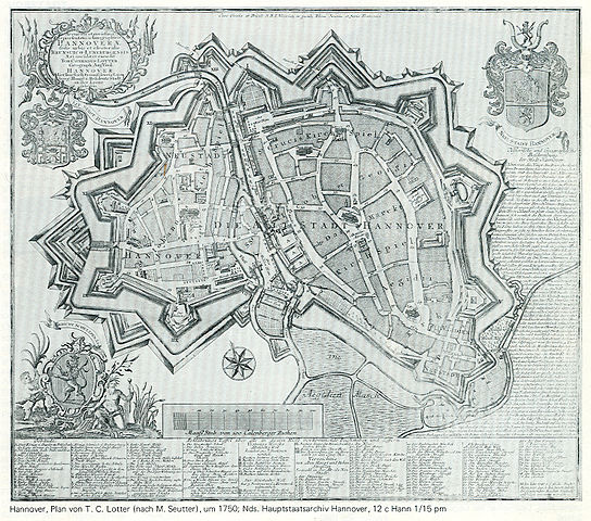
English: Map of of the cities of Hanover (with the new builded Aegidienneustadt in the south-east) and Calenberger Neustadt.
Deutsch: Um 1750: Plan der mit einer gemeinsamen Verteidigungsanlage umschlossenen Calenberger Neustadt (westlich des Leine-Flusses) und Hannover (östlich der Leine), im Südwesten auf einer ehemaligen Bastion die Aegidienneustadt. |
| Date | circa 1750 |
| Source | Scan of a little copy in the book Denkmaltopographie Bundesrepublik Deutschland, Baudenkmale in Niedersachsen, Stadt Hannover, Teil 1, Band 10.1, Seite 63 |
| Author | Kupferstecher: Tobias Conrad Lotter nach Matthäus Seutter nach Georg Friedrich Dinglinger; Geograph: Aug. Vind; |
52° 22′ N|9° 44′ O
Licensing
[edit]
|
This work is in the public domain in its country of origin and other countries and areas where the copyright term is the author's life plus 70 years or fewer. | |
| This file has been identified as being free of known restrictions under copyright law, including all related and neighboring rights. | |
File history
Click on a date/time to view the file as it appeared at that time.
| Date/Time | Thumbnail | Dimensions | User | Comment | |
|---|---|---|---|---|---|
| current | 08:59, 14 November 2010 | | 1,477 × 1,303 (3.38 MB) | Bernd Schwabe in Hannover (talk | contribs) | {{Information |Description={{en|1=Map of of the cities of Hanover (with the new builded Aegidienneustadt in the south-east) and ''Calenberger Neustadt''.}} {{de|1=Um 1750: Plan der mit einer gemeinsamen Verteidigungsanlage umschlossenen Calenberger Neusta |
You cannot overwrite this file.
File usage on Commons
The following 2 pages use this file:
File usage on other wikis
The following other wikis use this file:
- Usage on de.wikipedia.org