File:Gibraltar map-es.svg
Jump to navigation
Jump to search

Size of this PNG preview of this SVG file: 385 × 598 pixels. Other resolutions: 154 × 240 pixels | 309 × 480 pixels | 494 × 768 pixels | 659 × 1,024 pixels | 1,317 × 2,048 pixels | 2,020 × 3,140 pixels.
Original file (SVG file, nominally 2,020 × 3,140 pixels, file size: 1.57 MB)
Captions
Captions
Add a one-line explanation of what this file represents
Summary
[edit]| Camera location | | View this and other nearby images on: OpenStreetMap |
|---|
| Description |
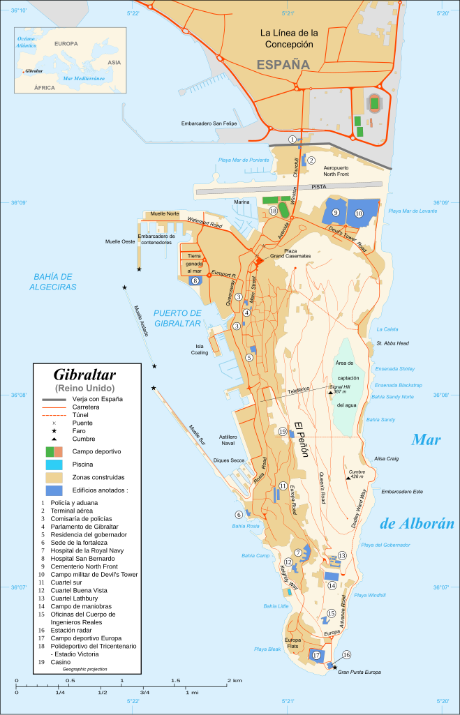
Map in Spanish of Gibraltar Español: Mapa de Gibraltar en Español |
||||||
| Date | |||||||
| Source |
Own work ; Map created using screenshots of Google Earth satellite imagery from a point of view located at 1.18 km of altitude (available imagery of November 2007) ; Other references : * CIA map ; * Gibnet map ; * U.K. MoD map Locator map : File:Blank map of South Europe and North Africa.svg (modified) created by Historicair ; Approximate scale : 1:40,000 (accuracy : about 10 m) Note : The roads width is proportional to reality |
||||||
| Author | Eric Gaba (Sting) | ||||||
| Permission (Reusing this file) |
Attribution and Share-Alike required | ||||||
| Other versions |
[]
|
||||||
| SVG development |
|


-es.svg)
-es.svg)
-es.svg)

Licensing
[edit]

|
Permission is granted to copy, distribute and/or modify this document under the terms of the GNU Free Documentation License, Version 1.2 or any later version published by the Free Software Foundation; with no Invariant Sections, no Front-Cover Texts, and no Back-Cover Texts. A copy of the license is included in the section entitled GNU Free Documentation License. |
| This file is licensed under the Creative Commons Attribution-Share Alike 3.0 Unported license. | ||
| ||
| This licensing tag was added to this file as part of the GFDL licensing update. |
File history
Click on a date/time to view the file as it appeared at that time.
| Date/Time | Thumbnail | Dimensions | User | Comment | |
|---|---|---|---|---|---|
| current | 14:18, 20 April 2011 | | 2,020 × 3,140 (1.57 MB) | Rastrojo (talk | contribs) | ortografía |
| 16:47, 16 December 2007 |  | 2,020 × 3,140 (1.57 MB) | Rastrojo (talk | contribs) | ||
| 17:47, 3 December 2007 |  | 2,020 × 3,140 (570 KB) | Gibmetal77 (talk | contribs) | {{Location|36|08|00|N|5|21|00|W|type:city_scale:50000}} {{Information |Description=Map in Spanish of Gibraltar |Source=Own work ;<br/>Map created using screenshots of Google Earth satellite imagery from a point |
You cannot overwrite this file.
File usage on Commons
The following 38 pages use this file:
- User:Hide on Rosé/Commons:Translation possible/Tìm hiểu thêm
- Commons:Translation possible/Ajuda
- Commons:Translation possible/Aprenda mais
- Commons:Translation possible/Aprende más
- Commons:Translation possible/Dowiedz się więcej
- Commons:Translation possible/Learn more
- Commons:Translation possible/Learn more/tr
- Commons:Translation possible/Mehr erfahren
- Commons:Translation possible/Para saber máis
- Commons:Translation possible/Per saperne di più
- Commons:Translation possible/Saznajte više
- Commons:Translation possible/Дознајте повеќе
- Commons:Translation possible/اطلاعات بیشتر
- Commons:Translation possible/了解更多
- Commons:Translation possible/詳情
- Commons:Translation possible/詳細
- Commons:Translation possible/더 보기
- File:Gibraltar map-HE.svg
- File:Gibraltar map-de.svg
- File:Gibraltar map-en-edit2.svg
- File:Gibraltar map-en.svg
- File:Gibraltar map-es.svg
- File:Gibraltar map-fr.svg
- File:Gibraltar map-hu.svg
- File:Gibraltar map-it.svg
- File:Gibraltar map-mk.svg
- File:Gibraltar map-ms.svg
- File:Gibraltar map-pl.svg
- File:Gibraltar map-uk.svg
- File:Gibraltar map-ur.svg
- File:Gibraltar map (claimed isthmus)-es.svg
- File:Gibraltar map (non Utrech territories)-es.svg
- File:Gibraltar map (reclaimed land)-es.svg
- File:Xibraltarplano-en.jpg
- File:Xibraltarplano-es.jpg
- File:Xibraltarplano-es cut.jpg
- File:Xibraltarplano-gl.jpg
- Template:Other versions/Gibraltar map
File usage on other wikis
The following other wikis use this file:
- Usage on an.wikipedia.org
- Usage on en.wikipedia.org
- Usage on es.wikipedia.org
- Gibraltar
- Wikiproyecto:Ilustración/Taller gráfico/Peticiones/Archivo 2
- Wikipedia:Imágenes destacadas/Diagramas, dibujos y mapas
- Wikipedia:Recurso del día/401 - 500
- Wikipedia:Candidatos a recursos destacados/Mayo-2010
- Wikipedia:Candidatos a recursos destacados/Gibraltar map-es.svg
- Plantilla:RDD/490
- Verja de Gibraltar
- Wikiproyecto:Ilustración/Taller gráfico/Peticiones/Archivo 11
- Wikipedia:Recurso del día/abril de 2011
- Demografía de Gibraltar
- Wikiproyecto:Ilustración/Taller gráfico/Peticiones/Archivo 12
- Wikipedia:Recurso del día/diciembre de 2012
- Museo de Gibraltar
- Wikipedia:Recurso del día/enero de 2015
- Usuario:Basquetteur/Taller
- Wikipedia:Recurso del día/mayo de 2017
- Wikipedia:Recurso del día/julio de 2019
- Wikipedia:Recurso del día/febrero de 2022
- Usage on gl.wikipedia.org