File:GreaterNottingham-map.png
Jump to navigation
Jump to search

Size of this preview: 800 × 524 pixels. Other resolutions: 320 × 210 pixels | 640 × 419 pixels | 1,024 × 671 pixels | 1,280 × 838 pixels | 2,443 × 1,600 pixels.
Original file (2,443 × 1,600 pixels, file size: 3.16 MB, MIME type: image/png)
Captions
Captions
Add a one-line explanation of what this file represents
Summary
[edit]
| Description |
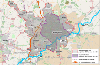
English: Nottingham Urban Area map. |
| Date | |
| Source | Own work + OpenStreetMap.org |
| Author | MrPanyGoff |
| Camera location | | View this and other nearby images on: OpenStreetMap |
|---|
Licensing
[edit]
 |
This illustration was made by MrPanyGoff
Please credit this : © Plamen Agov • studiolemontree in the immediate vicinity of the image. If you use some of my photos, an email to
Do not copy this image illegally by ignoring the terms of the license below, as it is not in the public domain. |
Plamen Agov • studiolemontree.com, the copyright holder of this work, hereby publishes it under the following licenses:
This file is licensed under the Creative Commons Attribution-Share Alike 3.0 Unported license.
Attribution: Plamen Agov • studiolemontree.com
- You are free:
- to share – to copy, distribute and transmit the work
- to remix – to adapt the work
- Under the following conditions:
- attribution – You must give appropriate credit, provide a link to the license, and indicate if changes were made. You may do so in any reasonable manner, but not in any way that suggests the licensor endorses you or your use.
- share alike – If you remix, transform, or build upon the material, you must distribute your contributions under the same or compatible license as the original.

|
Permission is granted to copy, distribute and/or modify this document under the terms of the GNU Free Documentation License, Version 1.2 or any later version published by the Free Software Foundation; with no Invariant Sections, no Front-Cover Texts, and no Back-Cover Texts. A copy of the license is included in the section entitled GNU Free Documentation License. |
You may select the license of your choice.
File history
Click on a date/time to view the file as it appeared at that time.
| Date/Time | Thumbnail | Dimensions | User | Comment | |
|---|---|---|---|---|---|
| current | 20:11, 28 October 2010 | | 2,443 × 1,600 (3.16 MB) | MrPanyGoff (talk | contribs) | {{Information |Description={{en|1=Nottingham Urban Area map.}} |Source={{own}} + OpenStreetMap.org |Author=MrPanyGoff |Date=2010-10-28 |Permission= |other_versions= }} {{location|52|57|9.99|N|1|11|41.15|W|region:GB}} [[Category:Notting |
You cannot overwrite this file.
File usage on Commons
The following 3 pages use this file:
File usage on other wikis
The following other wikis use this file:
- Usage on azb.wikipedia.org
- Usage on bg.wikipedia.org
- Usage on en.wikipedia.org
- Usage on ru.wikipedia.org
- Usage on simple.wikipedia.org
- Usage on uz.wikipedia.org
- Usage on www.wikidata.org