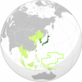
File:Greater Japanese empire.png
From Wikimedia Commons, the free media repository
Jump to navigation
Jump to search

Size of this preview: 600 × 600 pixels. Other resolutions: 240 × 240 pixels | 480 × 480 pixels | 1,004 × 1,004 pixels.
Original file (1,004 × 1,004 pixels, file size: 280 KB, MIME type: image/png)
File information
Structured data
Captions
Captions
Add a one-line explanation of what this file represents
Summary
[edit]The factual accuracy of this map or the file name is disputed.
Reason: w:South Pacific Mandate borders need to be redrawn to proper geocoordinates with curve |  |

|
File:Japanese Empire (orthographic projection).svg is a vector version of this file. It should be used in place of this PNG file when not inferior.
File:Greater Japanese empire.png → File:Japanese Empire (orthographic projection).svg
For more information, see Help:SVG.
|
| DescriptionGreater Japanese empire.png |
English: Japanese Empire at its peak (1942/1943) Green: Great Japanese Empire Lime: Japanese colonies/mandates Light lime: Puppet states and occupied territory of Japan |
| Date | 3 June 2010 (original upload date) |
| Source | Transferred from en.wikipedia to Commons by Sreejithk2000 using CommonsHelper. |
| Author | VoodooIsland at English Wikipedia |
Licensing
[edit]| Public domainPublic domainfalsefalse |
| This work has been released into the public domain by its author, VoodooIsland at English Wikipedia. This applies worldwide. In some countries this may not be legally possible; if so: VoodooIsland grants anyone the right to use this work for any purpose, without any conditions, unless such conditions are required by law.Public domainPublic domainfalsefalse |
Original upload log
[edit]The original description page was here. All following user names refer to en.wikipedia.
- 2010-06-03 10:42 VoodooIsland 1000×1000× (302963 bytes) minor China-Nanjing northern border extension
- 2010-06-03 10:30 VoodooIsland 1000×1000× (302922 bytes) China-Nanjing/Mengjiang border adjustment
- 2010-06-03 10:12 VoodooIsland 1000×1000× (302946 bytes)
- 2010-06-03 10:11 VoodooIsland 1000×1000× (302962 bytes)
- 2010-06-03 10:09 VoodooIsland 1000×1000× (302985 bytes)
- 2010-06-03 10:05 VoodooIsland 1000×1000× (303012 bytes)
- 2010-06-03 10:04 VoodooIsland 1000×1000× (305110 bytes) '''Green''': Great Japanese Empire<br>'''Lime''': Japanese [[Taiwan under Japanese rule|colonies]]/[[South Pacific Mandate|mandates]]<br>'''Light lime''': Puppet states and occupied territory of Japan
File history
Click on a date/time to view the file as it appeared at that time.
| Date/Time | Thumbnail | Dimensions | User | Comment | |
|---|---|---|---|---|---|
| current | 13:42, 23 May 2011 |  | 1,004 × 1,004 (280 KB) | Garam (talk | contribs) | Reverted to version as of 03:43, 29 April 2011 // Too. |
| 11:29, 12 May 2011 |  | 1,004 × 1,004 (278 KB) | Elmor (talk | contribs) | Still no answer | |
| 03:43, 29 April 2011 |  | 1,004 × 1,004 (280 KB) | Garam (talk | contribs) | Same reason. Answer, please. | |
| 20:13, 26 April 2011 |  | 1,004 × 1,004 (278 KB) | Elmor (talk | contribs) | No answer from the opponent | |
| 12:11, 7 April 2011 |  | 1,004 × 1,004 (280 KB) | Garam (talk | contribs) | Reverted to version as of 15:50, 23 February 2011 // It is your opinion. You can take part in File talk:Greater Japanese empire.png. Thank you. | |
| 14:44, 5 April 2011 |  | 1,004 × 1,004 (278 KB) | Commurist (talk | contribs) | Okinawa and Kuril Island are part of Empire oj Japan mainland. Not colony. Okinawa is Okinawa Prefecture, and Kuril Islands is part of Hokkaido. | |
| 15:50, 23 February 2011 |  | 1,004 × 1,004 (280 KB) | Garam (talk | contribs) | Reverted to version as of 04:52, 15 February 2011 // Ryukyu(Okinawa) and Kurils (Chishima) is not territory. Same the Choseon(Korea) and Taiwan(ROC). Please, don't make edit warrior and use the talk. Thank you. | |
| 10:09, 19 February 2011 |  | 1,004 × 1,004 (278 KB) | Elmor (talk | contribs) | Reverted to version as of 12:14, 9 February 2011 (no answer to my explanation) | |
| 04:52, 15 February 2011 |  | 1,004 × 1,004 (280 KB) | Garam (talk | contribs) | Look at the talk, please. | |
| 12:14, 9 February 2011 |  | 1,004 × 1,004 (278 KB) | Elmor (talk | contribs) | Okinawa and Kurils (Chishima) marked as Japan proper, borders changed to contemporary ones |
You cannot overwrite this file.
File usage on Commons
The following page uses this file:
File usage on other wikis
The following other wikis use this file:
- Usage on de.wikipedia.org
- Usage on en.wikipedia.org
