File:Greatvalley-map.jpg
Jump to navigation
Jump to search
Size of this preview: 587 × 599 pixels. Other resolutions: 235 × 240 pixels | 624 × 637 pixels.
Original file (624 × 637 pixels, file size: 385 KB, MIME type: image/jpeg)
Captions
Captions
Add a one-line explanation of what this file represents


|
This file has been superseded by Greatvalley-map.png. It is recommended to use the other file. Please note that deleting superseded images requires consent. Reason to use the other file: "A PNG version of this file is now available."
|

|
Summary
[edit]
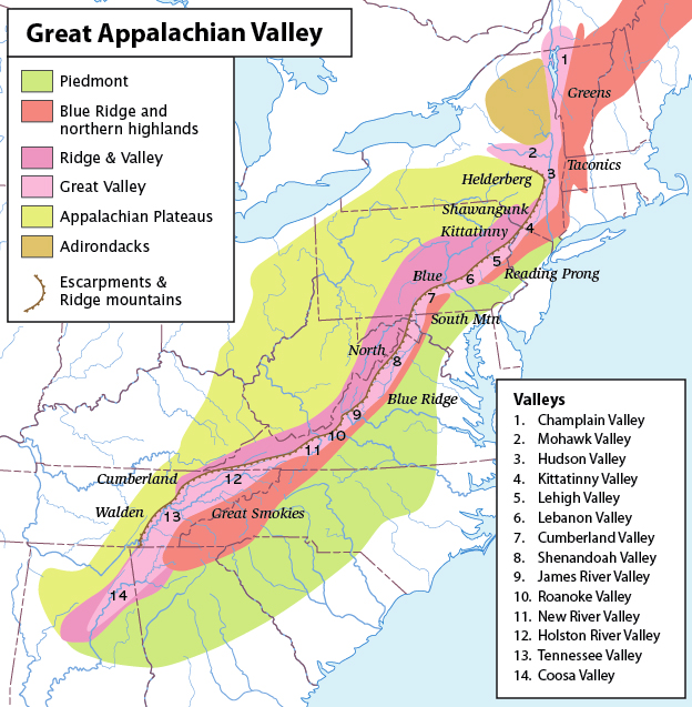
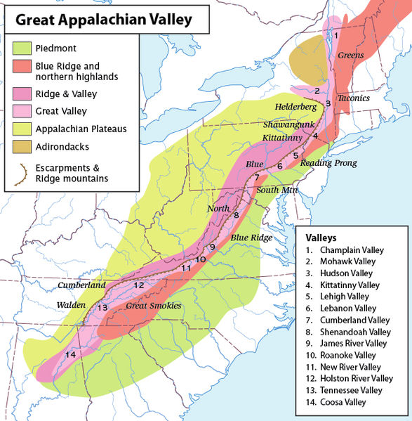
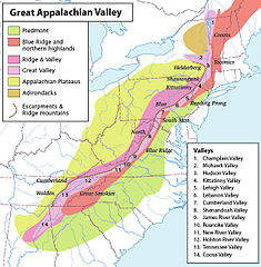
| Description | Map of the Appalachian Mountain physiographic regions, highlighting the Great Appalachian Valley, naming the main valleys making it up and the main mountains on either side. |
| Date | |
| Source | I made this map myself |
| Author | Pfly |
| Permission (Reusing this file) |
My own work; share-alike, attribution; CC-BY-SA-2.5 |
Licensing
[edit]
I, the copyright holder of this work, hereby publish it under the following license:
This file is licensed under the Creative Commons Attribution-Share Alike 2.5 Generic license.
- You are free:
- to share – to copy, distribute and transmit the work
- to remix – to adapt the work
- Under the following conditions:
- attribution – You must give appropriate credit, provide a link to the license, and indicate if changes were made. You may do so in any reasonable manner, but not in any way that suggests the licensor endorses you or your use.
- share alike – If you remix, transform, or build upon the material, you must distribute your contributions under the same or compatible license as the original.
File history
Click on a date/time to view the file as it appeared at that time.
| Date/Time | Thumbnail | Dimensions | User | Comment | |
|---|---|---|---|---|---|
| current | 06:22, 14 November 2006 | | 624 × 637 (385 KB) | Pfly (talk | contribs) | {{Information |Description=Map of the Appalachian Mountain physiographic regions, highlighting the Great Appalachian Valley, naming the main valleys making it up and the main mountains on either side. |Source=I made this map myself |Date=November 13, 2006 |
You cannot overwrite this file.
File usage on Commons
The following page uses this file: