File:Großdeutsches Reich-europe.png
Jump to navigation
Jump to search

Size of this preview: 666 × 600 pixels. Other resolutions: 267 × 240 pixels | 533 × 480 pixels | 853 × 768 pixels | 1,137 × 1,024 pixels | 1,829 × 1,647 pixels.
Original file (1,829 × 1,647 pixels, file size: 59 KB, MIME type: image/png)
Captions
Captions
Add a one-line explanation of what this file represents
| Description |
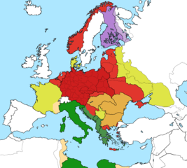
Deutsch: Karte der vom Deutschen Reich besetzten Gebiete und der Kriegsfronten im Zweiten Weltkrieg, 1941/42. English: A map of German front of the Second World War circa 1941-1942. Ελληνικά: Εδαφικές κατακτήσεις του Ράιχ Español: Conquistas territoriales del Reich |
| Date |
Original Image: 17 April 2005 English: Großdeutsches Reich in 1942 |
| Source | |
| Author |
The original uploader was Mackay 86 at English Wikipedia. |
| This is a retouched picture, which means that it has been digitally altered from its original version. Modifications: Combined Großdeutsches Reich core, Axis (tripartite members) occupied territory, puppet states and co-beliggerents. The original can be viewed here: Großdeutsches Reich.png:
|
This file is licensed under the Creative Commons Attribution-Share Alike 3.0 Unported license.
- You are free:
- to share – to copy, distribute and transmit the work
- to remix – to adapt the work
- Under the following conditions:
- attribution – You must give appropriate credit, provide a link to the license, and indicate if changes were made. You may do so in any reasonable manner, but not in any way that suggests the licensor endorses you or your use.
- share alike – If you remix, transform, or build upon the material, you must distribute your contributions under the same or compatible license as the original.
Original upload log
[edit]
This image is a derivative work of the following images:
- File:Second_world_war_europe_1941-1942_map_en.png licensed with Cc-by-sa-3.0-migrated, GFDL
- 2009-02-16T08:06:59Z Guinnog 1090x1000 (219499 Bytes) {{Information |Description=better titles |Source=*[[:File:Second_world_war_europe_1941-1942_map_en.png|]] |Date=2009-02-16 08:05 (UTC) |Author=*[[:File:Second_world_war_europe_1941-1942_map_en.png|]]: Sir Lothar *derivative w
- 2008-04-11T00:22:31Z Sir Lothar 0x0 (213362 Bytes)
- 2005-12-21T05:36:56Z ArmadniGeneral 0x0 (226037 Bytes) A map of the Eastern front of the Second World War circa 1941-1942. The original German-language map was created by [[User:San Jose]] on 17 April 2005. It can be found here: [[Image:Second world war europe 1941-1942 map de.pn
- File:Großdeutsches_Reich.png licensed with Cc-by-sa-3.0, GFDL
- 2010-09-10T00:10:09Z File Upload Bot (Magnus Manske) 1837x1655 (178154 Bytes) {{BotMoveToCommons|en.wikipedia|year={{subst:CURRENTYEAR}}|month={{subst:CURRENTMONTHNAME}}|day={{subst:CURRENTDAY}}}} {{Information |Description={{en|Großdeutsches Reich in 1942}} |Source=Transferred from [http://en.wikipe
Uploaded with derivativeFX
File history
Click on a date/time to view the file as it appeared at that time.
| Date/Time | Thumbnail | Dimensions | User | Comment | |
|---|---|---|---|---|---|
| current | 01:02, 28 July 2018 | | 1,829 × 1,647 (59 KB) | JeffyP (talk | contribs) | Shrinking file size |
| 20:20, 6 May 2018 |  | 1,829 × 1,647 (105 KB) | Spesh531 (talk | contribs) | trying again, Norwegian islands to red | |
| 20:19, 6 May 2018 |  | 1,829 × 1,647 (105 KB) | Spesh531 (talk | contribs) | updating color | |
| 20:17, 6 May 2018 |  | 1,829 × 1,647 (105 KB) | Spesh531 (talk | contribs) | adding italy, updating borders | |
| 20:00, 15 March 2011 |  | 1,837 × 1,655 (117 KB) | Hohum (talk | contribs) | {{Information |Description={{de|Karte der vom Deutschen Reich besetzten Gebiete und der Kriegsfronten im Zweiten Weltkrieg, 1941/42.}} {{en|A map of German front of the Second World War circa 1941-1942.}} {{el|Εδαφικές κατακτήσεις τ� |
You cannot overwrite this file.
File usage on Commons
The following 3 pages use this file:
File usage on other wikis
The following other wikis use this file:
- Usage on cy.wikipedia.org
- Usage on en.wikipedia.org