File:Gustave Cailllebote-Paar beim Spaziergang-04137.jpg

Original file (4,000 × 6,000 pixels, file size: 24.15 MB, MIME type: image/jpeg)
Captions
Captions
Summary
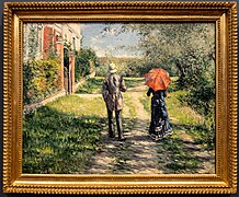
[edit]| Gustave Caillebotte: The Uphill Path
|
||||||||||||||||||||||||||||||
|---|---|---|---|---|---|---|---|---|---|---|---|---|---|---|---|---|---|---|---|---|---|---|---|---|---|---|---|---|---|---|
| Artist |
|
|||||||||||||||||||||||||||||
| Title | ||||||||||||||||||||||||||||||
| Object type |
painting |
|||||||||||||||||||||||||||||
| Genre |
landscape painting |
|||||||||||||||||||||||||||||
| Description |
Deutsch: Paar beim Spaziergang |
|||||||||||||||||||||||||||||
| Date | 26 August 2023 21:15:20+08:00 | |||||||||||||||||||||||||||||
| Medium |
oil on canvas |
|||||||||||||||||||||||||||||
| Dimensions |
height: 100.2 cm (39.4 in) dimensions QS:P2048,+100.2U174728 dimensions QS:P2049,+125.3U174728 |
|||||||||||||||||||||||||||||
| Collection |
institution QS:P195,Q23785329 |
|||||||||||||||||||||||||||||
| Accession number |
MB-Cai-03 (Museum Barberini) |
|||||||||||||||||||||||||||||
| Exhibition history |
|
|||||||||||||||||||||||||||||
| Inscriptions |
|
|||||||||||||||||||||||||||||
| References |
|
|||||||||||||||||||||||||||||
| Source/Photographer | Wuselig | |||||||||||||||||||||||||||||
| Other versions |
|
|||||||||||||||||||||||||||||
| Camera location | 52° 23′ 43.48″ N, 13° 03′ 43.46″ E | View this and other nearby images on: OpenStreetMap |
|---|

|
GLAM-on-Tour: Museum Barberini
Wikipedianer fotografierten am 25. bis 27. August 2023 Objekte im Museum Barberini in Potsdam. This photo was taken during a project supported by WMDE. Gefördert von / Supported by: Wikimedia Deutschland, Museum Barberini |
 |
Licensing
[edit]| This file is made available under the Creative Commons CC0 1.0 Universal Public Domain Dedication. | |
| The person who associated a work with this deed has dedicated the work to the public domain by waiving all of their rights to the work worldwide under copyright law, including all related and neighboring rights, to the extent allowed by law. You can copy, modify, distribute and perform the work, even for commercial purposes, all without asking permission.
http://creativecommons.org/publicdomain/zero/1.0/deed.enCC0Creative Commons Zero, Public Domain Dedicationfalsefalse |
File history
Click on a date/time to view the file as it appeared at that time.
| Date/Time | Thumbnail | Dimensions | User | Comment | |
|---|---|---|---|---|---|
| current | 10:04, 27 August 2023 |  | 4,000 × 6,000 (24.15 MB) | Wuselig (talk | contribs) | Uploaded with LrMediaWiki 1.8.0, LR 12.5 Win |
You cannot overwrite this file.
File usage on Commons
The following 3 pages use this file:
Metadata
This file contains additional information such as Exif metadata which may have been added by the digital camera, scanner, or software program used to create or digitize it. If the file has been modified from its original state, some details such as the timestamp may not fully reflect those of the original file. The timestamp is only as accurate as the clock in the camera, and it may be completely wrong.
| Camera manufacturer | SONY |
|---|---|
| Camera model | ILCE-6600 |
| Author | Rainer Halama |
| Copyright holder |
|
| Exposure time | 1/80 sec (0.0125) |
| F-number | f/4 |
| ISO speed rating | 2,000 |
| Date and time of data generation | 21:15, 26 August 2023 |
| Lens focal length | 47 mm |
| Latitude | 52° 23′ 43.48″ N |
| Longitude | 13° 3′ 43.45″ E |
| City shown | Potsdam |
| Horizontal resolution | 240 dpi |
| Vertical resolution | 240 dpi |
| Software used | Adobe Photoshop Lightroom Classic 12.5 (Windows) |
| File change date and time | 12:03, 27 August 2023 |
| Exposure Program | Aperture priority |
| Exif version | 2.31 |
| Date and time of digitizing | 21:15, 26 August 2023 |
| APEX shutter speed | 6.321928 |
| APEX aperture | 4 |
| APEX brightness | 1.634375 |
| APEX exposure bias | 0.3 |
| Maximum land aperture | 2.96875 APEX (f/2.8) |
| Metering mode | Center weighted average |
| Light source | Unknown |
| Flash | Flash did not fire, compulsory flash suppression |
| Color space | sRGB |
| Focal plane X resolution | 2,553.1914978027 |
| Focal plane Y resolution | 2,553.1914978027 |
| Focal plane resolution unit | 3 |
| File source | Digital still camera |
| Scene type | A directly photographed image |
| Custom image processing | Normal process |
| Exposure mode | Auto exposure |
| White balance | Auto white balance |
| Digital zoom ratio | 1 |
| Focal length in 35 mm film | 70 mm |
| Scene capture type | Standard |
| Contrast | Normal |
| Saturation | Normal |
| Sharpness | Normal |
| Receiver status | Measurement interoperability |
| Geodetic survey data used | WGS-84 |
| GPS differential correction | 0 |
| GPS tag version | 0.0.2.2 |
| Lens used | E 17-70mm F2.8 B070 |
| Date metadata was last modified | 14:03, 27 August 2023 |
| Unique ID of original document | 1CC3E0E778AB7A2B517A6485C4CFD312 |
| Keywords |
|
| Province or state shown | Brandenburg |
| Country shown | Deutschland |
| Sublocation of city shown | Nördliche Innenstadt |
| Code for country shown | DE |
| IIM version | 4 |
Structured data
Items portrayed in this file
depicts
52°23'43.48136"N, 13°3'43.45427"E
0.0125 second
47 millimetre
2,000
image/jpeg
- Pages with complex technique templates
- Artworks with Wikidata item
- Artworks with accession number from Wikidata
- Artworks with known accession number
- Artworks main subject 2D work
- Files with coordinates missing SDC location of creation
- Supported by Wikimedia Deutschland
- CC-Zero
- Files by User:Wuselig/GLAMonTour/GLAMhybrid Museum Barberini 2023
- Taken with Sony ILCE-6600
- Taken with Tamron 17-70mm F2.8 Di III-A VC RXD
- Uploaded with LrMediaWiki


