File:HSBC footprint.png
Jump to navigation
Jump to search

Size of this preview: 425 × 599 pixels. Other resolutions: 170 × 240 pixels | 340 × 480 pixels | 545 × 768 pixels | 726 × 1,024 pixels | 1,598 × 2,252 pixels.
Original file (1,598 × 2,252 pixels, file size: 286 KB, MIME type: image/png)
Captions
Captions
Add a one-line explanation of what this file represents
Summary
[edit]
| Description |
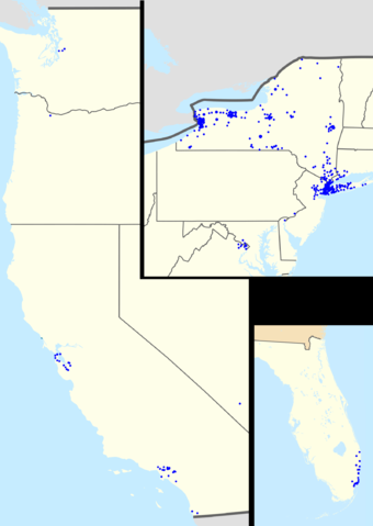
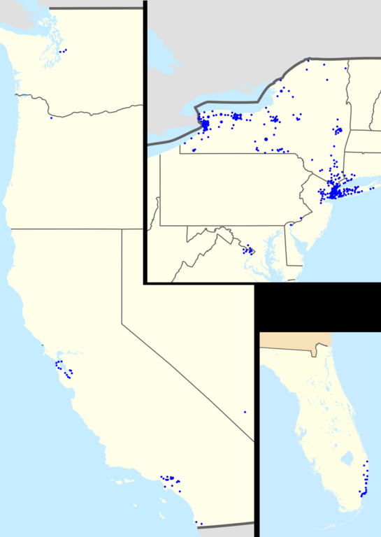
English: Footprint of HSBC Bank USA branches within the United States. Zip codes with more than one branch have progressively larger points. On the left, the US west coast, on the upper right, the eastern seaboard (New York state to Washington DC), the lower right: Florida. |
| Date | |
| Source |
This file was derived from: |
| Author |
|
| Point Maps
══▻ FAQ ◅══ ══▻ Create your own ◅══ |
Licensing
[edit]
This file is licensed under the Creative Commons Attribution-Share Alike 3.0 Unported license.
- You are free:
- to share – to copy, distribute and transmit the work
- to remix – to adapt the work
- Under the following conditions:
- attribution – You must give appropriate credit, provide a link to the license, and indicate if changes were made. You may do so in any reasonable manner, but not in any way that suggests the licensor endorses you or your use.
- share alike – If you remix, transform, or build upon the material, you must distribute your contributions under the same or compatible license as the original.
Original upload log
[edit]
The original description page was here. All following user names refer to en.wikipedia.
- 2010-07-18 20:54 Magog the Ogre 1598×2252× (292766 bytes) {{Information |Description=Footprint of [[HSBC Bank USA]] branches within the [[United States]]. Zip codes with more than one branch have progressively larger points. On the left, the US west coast, on the upper right, the eastern seaboard ([[New York sta
This image is a derivative work of the following images:
- File:USA_location_map.svg licensed with Cc-by-sa-3.0, GFDL
- 2008-07-29T20:04:42Z NordNordWest 1859x968 (738148 Bytes) {{Information |Description= {{de|Positionskarte der [[:de:Vereinigte Staaten|Vereinigten Staaten]]}} Quadratische Plattkarte, N-S-Streckung 120 %. Geographische Begrenzung der Karte: * N: 49.8° N * S: 24.2° N * W: 125.5° W
- File:USA_Florida_location_map.svg licensed with Cc-by-3.0
- 2008-12-15T20:25:08Z Sting 1132x1096 (591820 Bytes) Counties boundaries: thinner strokes
- 2008-12-15T19:49:40Z Sting 1132x1096 (591829 Bytes) == Summary == {{Location|27|45|00|N|83|49|30|W|scale:4000000}} {{Information |Description={{en|Blank administrative map of the State of [[:en:Florida|Florida]], [[:en:United States|USA]], for geo-location purpose, with count
File history
Click on a date/time to view the file as it appeared at that time.
| Date/Time | Thumbnail | Dimensions | User | Comment | |
|---|---|---|---|---|---|
| current | 21:01, 28 July 2012 | | 1,598 × 2,252 (286 KB) | OgreBot (talk | contribs) | (BOT): Uploading old version of file from en.wikipedia; originally uploaded on 2010-07-18 20:54:43 by Magog the Ogre |
You cannot overwrite this file.
File usage on Commons
There are no pages that use this file.
File usage on other wikis
The following other wikis use this file:
- Usage on fr.wikipedia.org