File:Hagupit 2014-12-04 043847Z.jpg
Jump to navigation
Jump to search

Size of this preview: 800 × 600 pixels. Other resolutions: 320 × 240 pixels | 640 × 480 pixels | 1,024 × 768 pixels | 1,280 × 960 pixels | 2,560 × 1,920 pixels | 6,720 × 5,040 pixels.
Original file (6,720 × 5,040 pixels, file size: 7.42 MB, MIME type: image/jpeg)
Captions
Captions
Add a one-line explanation of what this file represents
Summary
[edit]| Description |
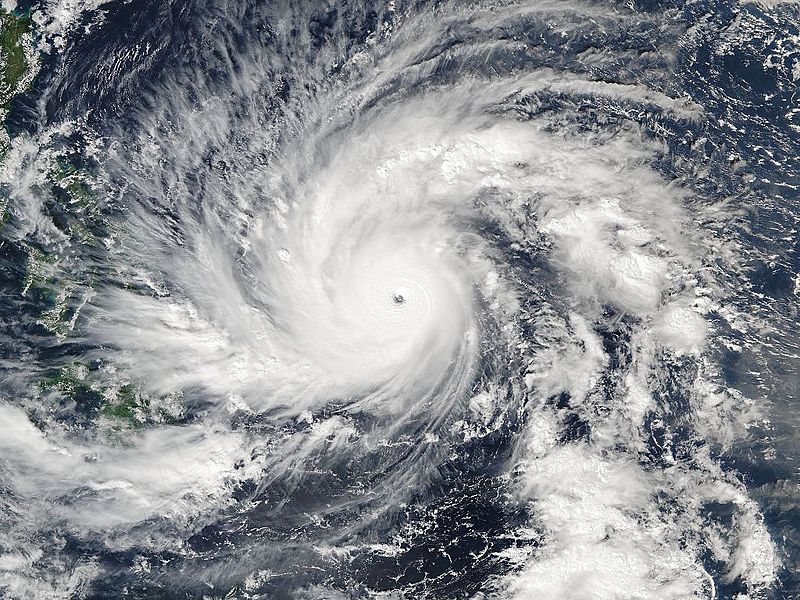
English: The Visible Infrared Imaging Radiometer Suite (VIIRS) sensor on Suomi-NPP captured this image of Typhoon Hagupit shortly before peak intensity on December 4, 2014, at 04:38 Universal Time. |
| Date | |
| Source | http://tropic.ssec.wisc.edu/storm_archive/2014/storms/22W/strabala/npp_viirs_true_color_crefl_None_20141204_043847_wgs84_fit_250.jpg |
| Author | VIIRS imagery from the Suomi NPP satellite, provided by the Cooperative Institute for Meteorological Satellite Studies |
| Other versions |
|

| Camera location | | View this and other nearby images on: OpenStreetMap |
|---|
Licensing
[edit]This image was produced by the SSEC/CIMSS, University of Wisconsin–Madison. All the images published on their website can be freely used, as long as the source is acknowledged. (disclaimer (archive))
|
 |

File history
Click on a date/time to view the file as it appeared at that time.
| Date/Time | Thumbnail | Dimensions | User | Comment | |
|---|---|---|---|---|---|
| current | 14:06, 10 December 2014 | | 6,720 × 5,040 (7.42 MB) | Meow (talk | contribs) | User created page with UploadWizard |
You cannot overwrite this file.
File usage on Commons
The following page uses this file: