File:Haupteinheitengruppen Tiefland Westteil.png
Jump to navigation
Jump to search
Size of this preview: 647 × 599 pixels. Other resolutions: 259 × 240 pixels | 518 × 480 pixels | 1,000 × 926 pixels.
Original file (1,000 × 926 pixels, file size: 1.22 MB, MIME type: image/png)
Captions
Captions
Add a one-line explanation of what this file represents
Summary
[edit]
| Description |
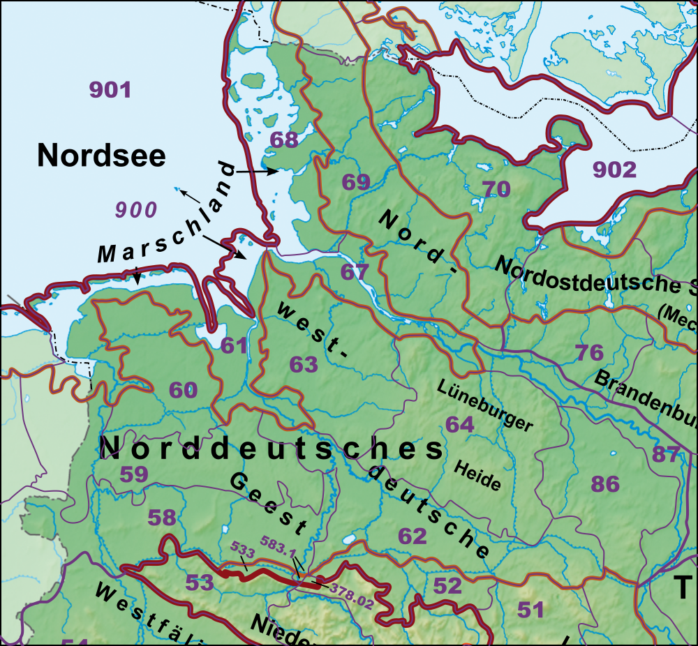
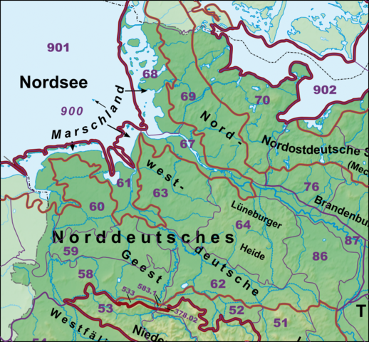
Deutsch: Haupteinheitengruppen im Westen des Norddeutschen Tieflandes nebst Lössbörden |
| Source | |
| Author | |
| Other versions | Siehe komplette Galerie |
Licensing
[edit]
I, the copyright holder of this work, hereby publish it under the following licenses:

|
Permission is granted to copy, distribute and/or modify this document under the terms of the GNU Free Documentation License, Version 1.2 or any later version published by the Free Software Foundation; with no Invariant Sections, no Front-Cover Texts, and no Back-Cover Texts. A copy of the license is included in the section entitled GNU Free Documentation License. |
This file is licensed under the Creative Commons Attribution-Share Alike 3.0 Unported license.
- You are free:
- to share – to copy, distribute and transmit the work
- to remix – to adapt the work
- Under the following conditions:
- attribution – You must give appropriate credit, provide a link to the license, and indicate if changes were made. You may do so in any reasonable manner, but not in any way that suggests the licensor endorses you or your use.
- share alike – If you remix, transform, or build upon the material, you must distribute your contributions under the same or compatible license as the original.
You may select the license of your choice.
File history
Click on a date/time to view the file as it appeared at that time.
| Date/Time | Thumbnail | Dimensions | User | Comment | |
|---|---|---|---|---|---|
| current | 18:55, 23 December 2020 | | 1,000 × 926 (1.22 MB) | Elop (talk | contribs) | |
| 23:20, 25 December 2014 |  | 1,000 × 926 (1.19 MB) | Elop (talk | contribs) | war falscher Ausschnitt | |
| 19:01, 25 December 2014 |  | 1,000 × 926 (1.14 MB) | Elop (talk | contribs) | update | |
| 13:49, 22 November 2014 |  | 1,000 × 924 (1,009 KB) | Elop (talk | contribs) | update | |
| 15:34, 1 July 2012 |  | 1,000 × 924 (1.07 MB) | Elop (talk | contribs) | update | |
| 00:32, 25 October 2011 |  | 1,000 × 896 (2.57 MB) | Elop (talk | contribs) | k | |
| 16:28, 24 October 2011 |  | 1,000 × 889 (2.55 MB) | Elop (talk | contribs) | Grenzkorrektur Weser/Aller | |
| 15:25, 24 October 2011 |  | 1,000 × 876 (2.51 MB) | Elop (talk | contribs) | smaller | |
| 12:48, 24 October 2011 |  | 1,000 × 1,289 (3.7 MB) | Elop (talk | contribs) | more details | |
| 14:25, 2 October 2011 |  | 913 × 999 (2.61 MB) | Elop (talk | contribs) | == {{int:filedesc}} == {{Information |Description={{de|1=Haupteinheitengruppen im Westen des Norddeutschen Tieflandes nebst Lössbörden}} |Source=*[[:Image:Deutschland_Naturräumliche Haupteinheiten.png|Deutschland_Naturräumli |
You cannot overwrite this file.
File usage on Commons
The following page uses this file:
File usage on other wikis
The following other wikis use this file:
- Usage on cs.wikipedia.org
- Usage on de.wikipedia.org
- Norddeutsches Tiefland
- Naturräumliche Großregionen Deutschlands
- Dümmer-Geestniederung
- Ostfriesisch-Oldenburgische Geest
- Hohe Heide
- Südheide
- Luheheide
- Benutzer:Aeroid/List DE NI-WL
- Benutzer:Aeroid/Geo North European Plain
- Benutzer:Aeroid/Natural region DE 64
- Benutzer:Aeroid/List DE NI Natural region
- Benutzer:Aeroid/List DE HH-unmittelbar
- Usage on en.wikipedia.org
- Usage on nds.wikipedia.org
- Usage on www.wikidata.org