File:Hazel 1954 track.png
Jump to navigation
Jump to search
Size of this preview: 600 × 600 pixels. Other resolutions: 240 × 240 pixels | 480 × 480 pixels | 768 × 768 pixels | 1,024 × 1,024 pixels | 2,048 × 2,048 pixels | 2,700 × 2,700 pixels.
Original file (2,700 × 2,700 pixels, file size: 4.48 MB, MIME type: image/png)
Captions
Captions
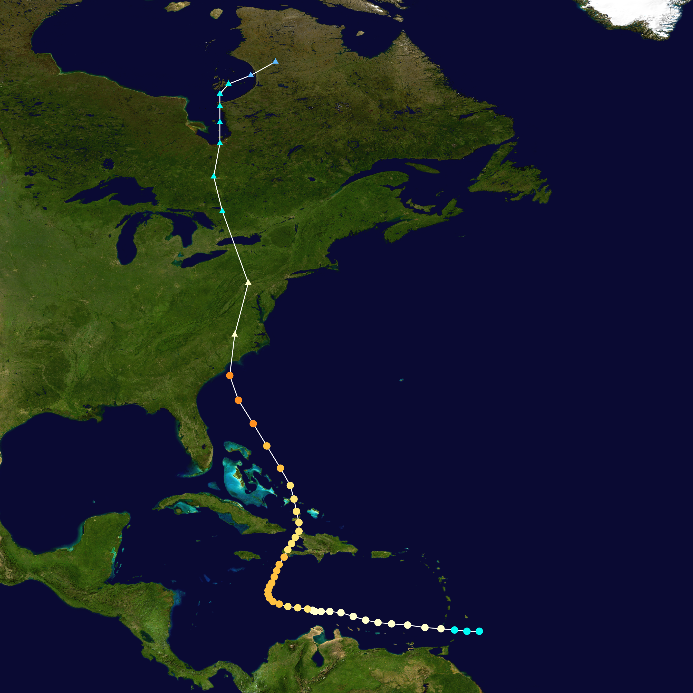
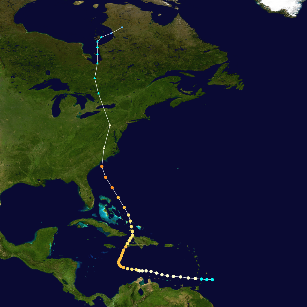
The track of Hurricane Hazel.
Summary
| Description |
English: Track map of Hurricane Hazel of the 1954 Atlantic hurricane season. The points show the location of the storm at 6-hour intervals. The colour represents the storm's maximum sustained wind speeds as classified in the (see below), and the shape of the data points represent the nature of the storm, according to the legend below. Tropical depression (≤38 mph, ≤62 km/h)
Tropical storm (39–73 mph, 63–118 km/h)
Category 1 (74–95 mph, 119–153 km/h)
Category 2 (96–110 mph, 154–177 km/h)
Category 3 (111–129 mph, 178–208 km/h)
Category 4 (130–156 mph, 209–251 km/h)
Category 5 (≥157 mph, ≥252 km/h)
Unknown
Storm type |
||
| Date | 1954-10-05–1954-10-18 | ||
| Source | Created by Supportstorm using Wikipedia:WikiProject Tropical cyclones/Tracks. The background image is from NASA. Tracking data is from HURDAT. | ||
| Author | Supportstorm | ||
| Source code | Track map data table, if present below, is in HURDAT2 or ATCF format. See format details in [1] and [2], respectively.
|
Licensing
[edit]| This work has been released into the public domain by its author, Supportstorm. This applies worldwide. In some countries this may not be legally possible; if so: Supportstorm grants anyone the right to use this work for any purpose, without any conditions, unless such conditions are required by law. |
File history
Click on a date/time to view the file as it appeared at that time.
| Date/Time | Thumbnail | Dimensions | User | Comment | |
|---|---|---|---|---|---|
| current | 01:24, 8 February 2023 | | 2,700 × 2,700 (4.48 MB) | Supportstorm (talk | contribs) | Reverted to version as of 01:30, 8 May 2015 (UTC) Unnecessary revert |
| 21:23, 7 February 2023 |  | 1,024 × 878 (524 KB) | Hurricane Allen (talk | contribs) | Reverted to version as of 23:06, 13 July 2006 (UTC) | |
| 01:30, 8 May 2015 |  | 2,700 × 2,700 (4.48 MB) | Supportstorm (talk | contribs) | HURDAT update | |
| 23:06, 13 July 2006 |  | 1,024 × 878 (524 KB) | Nilfanion (talk | contribs) | ||
| 20:32, 29 December 2005 |  | 1,024 × 878 (524 KB) | Jdorje~commonswiki (talk | contribs) | {{Hurricane auto track map|Hurricane Hazel (1954)}} | |
| 20:22, 29 December 2005 |  | 1,024 × 1,024 (818 KB) | Jdorje~commonswiki (talk | contribs) | {{Hurricane auto track map|Hurricane Hazel (1954)}} | |
| 00:07, 12 November 2005 |  | 1,024 × 692 (360 KB) | Jdorje~commonswiki (talk | contribs) | {{Hurricane auto track map|Hurricane Hazel (1954)}} |
You cannot overwrite this file.
File usage on Commons
The following page uses this file:
File usage on other wikis
The following other wikis use this file:
- Usage on en.wikipedia.org
- Usage on es.wikipedia.org
- Usage on fi.wikipedia.org
- Usage on fr.wikipedia.org
- Usage on pl.wikipedia.org
- Usage on pt.wikipedia.org
- Usage on simple.wikipedia.org
- Usage on zh.wikipedia.org