File:Hessen-Homburg.png
Jump to navigation
Jump to search

Size of this preview: 800 × 480 pixels. Other resolutions: 320 × 192 pixels | 1,024 × 614 pixels | 1,280 × 768 pixels | 2,362 × 1,417 pixels.
Original file (2,362 × 1,417 pixels, file size: 582 KB, MIME type: image/png)
Captions
Captions
Add a one-line explanation of what this file represents
Summary
[edit]
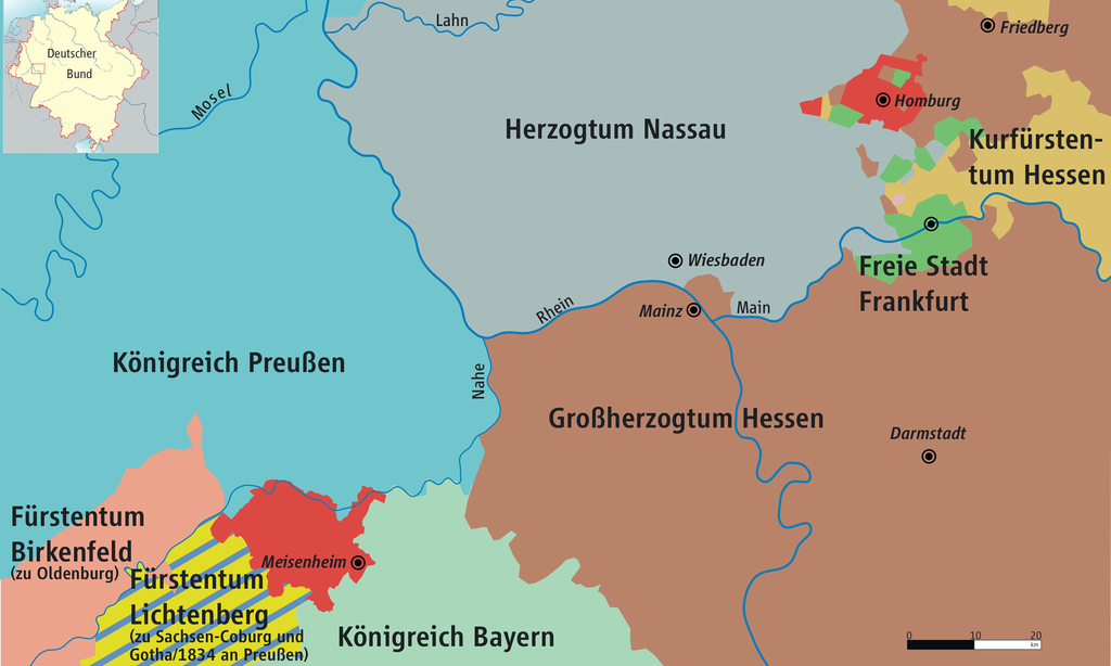
| Description | Karte von Hessen-Homburg und Mittelrheingebiet 1816–1866 / Map of Hesse-Homburg and Middle Rhine 1816–1866 |
| Date | |
| Source | own drawing/Source of Information: Putzger – Historischer Weltatlas, 89. Auflage, 1965 & de: Jean Joseph Tranchot / de: Karl von Müffling |
| Author | Ziegelbrenner |
| Permission (Reusing this file) |
GNU FDL |

|
This map has been made or improved in the German Kartenwerkstatt (Map Lab). You can propose maps to improve as well.
|
Licensing
[edit]
I, the copyright holder of this work, hereby publish it under the following licenses:

|
Permission is granted to copy, distribute and/or modify this document under the terms of the GNU Free Documentation License, Version 1.2 or any later version published by the Free Software Foundation; with no Invariant Sections, no Front-Cover Texts, and no Back-Cover Texts. A copy of the license is included in the section entitled GNU Free Documentation License. |
| This file is licensed under the Creative Commons Attribution-Share Alike 3.0 Unported license. | ||
| ||
| This licensing tag was added to this file as part of the GFDL licensing update. |
You may select the license of your choice.

|
File:Hessen-Homburg.svg is a vector version of this file. It should be used in place of this PNG file.
File:Hessen-Homburg.png → File:Hessen-Homburg.svg
For more information, see Help:SVG. |
 |
File history
Click on a date/time to view the file as it appeared at that time.
| Date/Time | Thumbnail | Dimensions | User | Comment | |
|---|---|---|---|---|---|
| current | 13:56, 9 June 2010 | | 2,362 × 1,417 (582 KB) | Ziegelbrenner (talk | contribs) | 2010-06-09 |
| 14:30, 26 September 2008 |  | 2,362 × 1,408 (584 KB) | Ziegelbrenner (talk | contribs) | {{Information |Description= |Source= |Date= |Author= |Permission= |other_versions= }} | |
| 12:30, 8 October 2007 |  | 2,840 × 1,691 (245 KB) | Ziegelbrenner (talk | contribs) | ||
| 12:41, 4 January 2007 |  | 2,837 × 1,687 (933 KB) | Ziegelbrenner (talk | contribs) | ||
| 14:54, 22 December 2006 |  | 2,837 × 1,694 (863 KB) | Ziegelbrenner (talk | contribs) | ||
| 10:36, 1 August 2006 |  | 652 × 390 (89 KB) | Ziegelbrenner (talk | contribs) | == Summary == * Description: Karte von Hessen-Homburg und Mittelrheingebiet 1816–1866 / Map of Hesse-Homburg and Middle Rhein 1816–1866 * Source of Information: Jean Joseph Tranchot und Karl von Müffling * Author: kgberger | |
| 10:52, 18 July 2006 |  | 835 × 416 (55 KB) | Ziegelbrenner (talk | contribs) | == Summary == Deutscher_Bund.png * Description: Karte von Hessen-Homburg und Mittelrheingebiet 1816-1866 / Map of Hesse-Homburg and Middle Rhein * Source: Tranchot und von Müffling * Author: [[:de:Benutzer |
You cannot overwrite this file.
File usage on Commons
There are no pages that use this file.
File usage on other wikis
The following other wikis use this file:
- Usage on bg.wikipedia.org
- Usage on eo.wikipedia.org
- Usage on et.wikipedia.org
- Usage on gd.wikipedia.org
- Usage on it.wikipedia.org
- Usage on no.wikipedia.org
- Usage on pl.wikipedia.org
- Usage on ru.wikipedia.org
- Usage on sv.wikipedia.org
- Usage on zh.wikipedia.org