File:Hessen-Homburg.svg
Jump to navigation
Jump to search

Size of this PNG preview of this SVG file: 800 × 473 pixels. Other resolutions: 320 × 189 pixels | 640 × 379 pixels | 1,024 × 606 pixels | 1,280 × 757 pixels | 2,560 × 1,514 pixels | 857 × 507 pixels.
Original file (SVG file, nominally 857 × 507 pixels, file size: 427 KB)
Captions
Captions
Add a one-line explanation of what this file represents
Summary
[edit]
| Description |
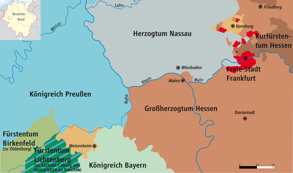
Deutsch: Karte von Hessen-Homburg und Mittelrheingebiet 1816–1866
English: Map of Hesse-Homburg and Middle Rhine 1816–1866
Français : Carte de Hesse-Hombourg et du Rhin moyen 1816–1866 |
| Date | |
| Source | own drawing/Source of Information: Putzger – Historischer Weltatlas, 89. Auflage, 1965 & de: Jean Joseph Tranchot / de: Karl von Müffling |
| Author | ziegelbrenner |
| Permission (Reusing this file) |
GNU FDL |
Licensing
[edit]
I, the copyright holder of this work, hereby publish it under the following licenses:

|
Permission is granted to copy, distribute and/or modify this document under the terms of the GNU Free Documentation License, Version 1.2 or any later version published by the Free Software Foundation; with no Invariant Sections, no Front-Cover Texts, and no Back-Cover Texts. A copy of the license is included in the section entitled GNU Free Documentation License. |
| This file is licensed under the Creative Commons Attribution-Share Alike 3.0 Unported license. | ||
| ||
| This licensing tag was added to this file as part of the GFDL licensing update. |
This file is licensed under the Creative Commons Attribution 2.5 Generic license.
- You are free:
- to share – to copy, distribute and transmit the work
- to remix – to adapt the work
- Under the following conditions:
- attribution – You must give appropriate credit, provide a link to the license, and indicate if changes were made. You may do so in any reasonable manner, but not in any way that suggests the licensor endorses you or your use.
You may select the license of your choice.
File history
Click on a date/time to view the file as it appeared at that time.
| Date/Time | Thumbnail | Dimensions | User | Comment | |
|---|---|---|---|---|---|
| current | 14:36, 21 February 2017 | | 857 × 507 (427 KB) | Ziegelbrenner (talk | contribs) | Farben angepasst | colours adapted |
| 12:03, 14 August 2008 |  | 698 × 422 (527 KB) | Ziegelbrenner (talk | contribs) | {{Information |Description= |Source= |Date= |Author= |Permission= |other_versions= }} | |
| 14:28, 15 January 2008 |  | 680 × 408 (251 KB) | Ziegelbrenner (talk | contribs) | ||
| 14:23, 15 January 2008 |  | 698 × 422 (121 KB) | Ziegelbrenner (talk | contribs) | == Beschreibung == {{Information |Description=Karte von Hessen-Homburg und Mittelrheingebiet 1816–1866 / Map of Hesse-Homburg and Middle Rhine 1816–1866 |Source=own drawing/Source of Information: Putzger – Historischer Weltatlas, 89. Auflage, 1965 & |
You cannot overwrite this file.
File usage on Commons
The following 2 pages use this file:
File usage on other wikis
The following other wikis use this file:
- Usage on de.wikipedia.org
- Usage on en.wikipedia.org
- Usage on fr.wikipedia.org
- Usage on he.wikipedia.org
- Usage on ja.wikipedia.org
- Usage on mk.wikipedia.org
- Usage on nl.wikipedia.org
- Usage on uk.wikipedia.org
- Usage on vi.wikipedia.org
- Usage on www.wikidata.org