File:Holy Roman Empire 1000 map-ru.svg
Jump to navigation
Jump to search

Size of this PNG preview of this SVG file: 488 × 599 pixels. Other resolutions: 196 × 240 pixels | 391 × 480 pixels | 626 × 768 pixels | 834 × 1,024 pixels | 1,669 × 2,048 pixels | 1,000 × 1,227 pixels.
Original file (SVG file, nominally 1,000 × 1,227 pixels, file size: 560 KB)
Captions
Captions
Add a one-line explanation of what this file represents
Summary
[edit]| Description |
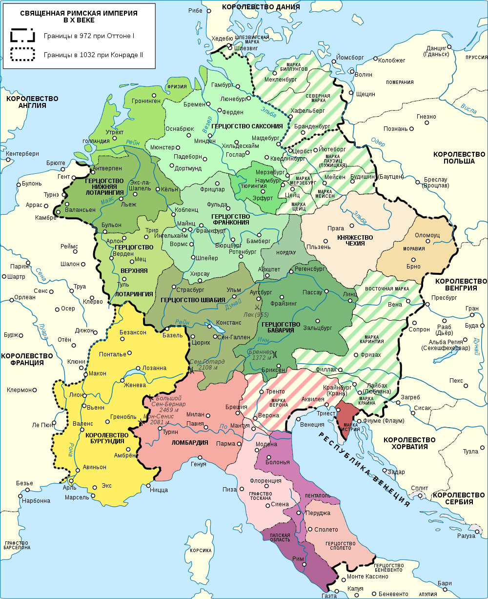
English: Map of the Holy Roman Empire near year 1000. Russian Version
Français : Carte du Saint-Empire romain germanique vers l'an mille. La version Russe
Русский: Карта Священной Римской империи около 1000 года. Русская версия
Български: Карта на Свещената Римска империя през X в. Руска версия |
| Date | (original uploads), 2008-12-03 (Russian translation) |
| Source |
travail personnel (own work). Source :
|
| Author | Sémhur (French original); Volodimer (Russian translation) |
| Other versions |
[]
|


| Camera location | | View this and other nearby images on: OpenStreetMap |
|---|

|
This SVG file contains embedded text that can be translated into your language, using any capable SVG editor, text editor or the SVG Translate tool. For more information see: About translating SVG files. |
This W3C-unspecified vector image was created with Inkscape .
Licensing
[edit]
I, the copyright holder of this work, hereby publish it under the following licenses:

|
Permission is granted to copy, distribute and/or modify this document under the terms of the GNU Free Documentation License, Version 1.2 or any later version published by the Free Software Foundation; with no Invariant Sections, no Front-Cover Texts, and no Back-Cover Texts. A copy of the license is included in the section entitled GNU Free Documentation License. |
This file is licensed under the Creative Commons Attribution-Share Alike 3.0 Unported, 2.5 Generic, 2.0 Generic and 1.0 Generic license.
- You are free:
- to share – to copy, distribute and transmit the work
- to remix – to adapt the work
- Under the following conditions:
- attribution – You must give appropriate credit, provide a link to the license, and indicate if changes were made. You may do so in any reasonable manner, but not in any way that suggests the licensor endorses you or your use.
- share alike – If you remix, transform, or build upon the material, you must distribute your contributions under the same or compatible license as the original.
You may select the license of your choice.
File history
Click on a date/time to view the file as it appeared at that time.
| Date/Time | Thumbnail | Dimensions | User | Comment | |
|---|---|---|---|---|---|
| current | 19:02, 2 September 2020 | | 1,000 × 1,227 (560 KB) | Gzhegozh (talk | contribs) | Reverted to version as of 16:03, 13 February 2009 (UTC) |
| 18:47, 2 September 2020 |  | 1,000 × 1,227 (748 KB) | Gzhegozh (talk | contribs) | File uploaded using svgtranslate tool (https://svgtranslate.toolforge.org/). Added translation for uk. | |
| 16:03, 13 February 2009 |  | 1,000 × 1,227 (560 KB) | Vladimir Solovjev (talk | contribs) | Исправлена опечатка | |
| 19:06, 3 December 2008 |  | 1,000 × 1,227 (560 KB) | Vladimir Solovjev (talk | contribs) | == Description == {{Information |Description={{en|1=Map of the Holy Roman Empire near year 1000. Russian Version}} {{fr|1=Carte du Saint-Empire romain germanique vers l'an mille.}} {{en|1=К |
You cannot overwrite this file.
File usage on Commons
The following 16 pages use this file:
- User:Magog the Ogre/Multilingual legend/2020 September 1-10
- File:Holy Roman Empire 1000 map-bg.svg
- File:Holy Roman Empire 1000 map-ca.svg
- File:Holy Roman Empire 1000 map-de.png
- File:Holy Roman Empire 1000 map-de.svg
- File:Holy Roman Empire 1000 map-es.svg
- File:Holy Roman Empire 1000 map-fr.svg
- File:Holy Roman Empire 1000 map-ka.svg
- File:Holy Roman Empire 1000 map-ko.svg
- File:Holy Roman Empire 1000 map-ru.svg
- File:Holy Roman Empire 1000 map-uk.svg
- File:Holy Roman Empire 1000 map with more colours-fr.svg
- File:Holy Roman Empire 11th century map-en.svg
- File:Holy Roman Empire 11th century map-hu.svg
- File:Holy Roman Empire 11th century map-zh-hans.svg
- Template:Other versions/Holy Roman Empire 1000 map
File usage on other wikis
The following other wikis use this file:
- Usage on azb.wikipedia.org
- Usage on az.wikipedia.org
- Usage on ba.wikipedia.org
- Usage on be-tarask.wikipedia.org
- Usage on be.wikipedia.org
- Usage on bg.wikipedia.org
- Usage on ka.wikipedia.org
- Usage on lez.wikipedia.org
- Usage on lt.wikipedia.org
- Usage on mn.wikipedia.org
- Usage on ru.wikipedia.org
- Священная Римская империя
- Оттон I Великий
- Лотарингия (герцогство)
- Франкония
- Генрих I Птицелов
- История Чехии
- Племенные герцогства
- Швабия (герцогство)
- Средневековая Италия
- Участник:Samvlamix
- Генрих II Святой
- Участник:Vladimir Solovjev/Заготовки
- Феофано (императрица Священной Римской империи)
- Бавария (герцогство)
- Франкония (герцогство)
- Мерзебург (маркграфство)
- Цайц (маркграфство)
- Туринская марка
- Нордгау (маркграфство)
- История Бургундии
- Спор Зибеля — Фикера
- История Франконии
- Usage on tt.wikipedia.org