File:Hoofdwacht Buitenhof Den Haag.jpg

Original file (615 × 739 pixels, file size: 684 KB, MIME type: image/jpeg)
Captions
Captions
Summary
[edit]| Description |
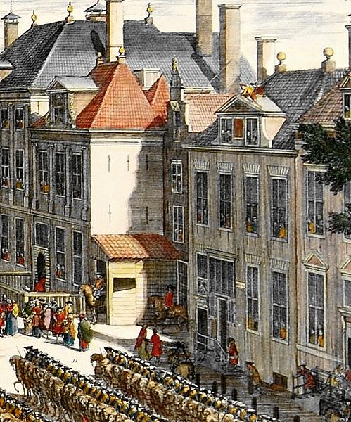
Nederlands: De Hoofdwacht op het Buitenhof in Den Haag. Het gebouw lag eeuwenlang achter de rooilijn. Te zien zijn een voorbouw, zijnde een afdak waaronder een ruiterwachter van het Garnizoen van Den Haag de wacht houdt. Nog net zichtbaar is de smalle trappengevel van (een deel van) het gebouw.
English: The main guard at the Buitenhof in The Hague. For centuries the building was situated behind the building line. Visible is an addition in front of the building, with a canopy under which an equestrian guard of the Hague Garrison keeps watch. Just visible is the narrow stairs façade of (part of) the building.
Deutsch: Die Hauptwache an den Buitenhof in Den Haag. Seit Jahrhunderten war das Gebäude hinter dem Gebäude Linie. Sichtbar ist eine Ergänzung vor dem Gebäude, mit einem Baldachin, unter dem ein Reitergarde des Haager Garnison hält Wache. Nur sichtbar ist die schmale Treppe Fassade (eines Teils) des Gebäudes.
Français : Le principal garde aux Buitenhof à La Haye. Pendant des siècles, le bâtiment était situé derrière la ligne de construction. Visible est une addition en face de l'immeuble, avec un auvent sous lequel un garde équestre de la garnison de La Haye maintient de regarder. Même évident est la façade escalier étroit (d'une partie) du bâtiment. |
|||||||||||||||||||||||
| Date | ||||||||||||||||||||||||
| Source | File:'s-Gravenhage (Haagse Kermis) - Daniel Marot.jpg | |||||||||||||||||||||||
| Author |
|
|||||||||||||||||||||||
.jpg)
_-_Daniel_Marot.jpg)
| Camera location | | View this and other nearby images on: OpenStreetMap |
|---|
Licensing
[edit]
This image is in the public domain because it is a mere mechanical scan or photocopy of a public domain original, or – from the available evidence – is so similar to such a scan or photocopy that no copyright protection can be expected to arise. The original itself is in the public domain for the following reason:
This tag is designed for use where there may be a need to assert that any enhancements (eg brightness, contrast, colour-matching, sharpening) are in themselves insufficiently creative to generate a new copyright. It can be used where it is unknown whether any enhancements have been made, as well as when the enhancements are clear but insufficient. For known raw unenhanced scans you can use an appropriate {{PD-old}} tag instead. For usage, see Commons:When to use the PD-scan tag.  | ||||
File history
Click on a date/time to view the file as it appeared at that time.
| Date/Time | Thumbnail | Dimensions | User | Comment | |
|---|---|---|---|---|---|
| current | 17:38, 2 June 2016 | | 615 × 739 (684 KB) | OSeveno (talk | contribs) | User created page with UploadWizard |
You cannot overwrite this file.
File usage on Commons
There are no pages that use this file.
File usage on other wikis
The following other wikis use this file:
- Usage on nl.wikipedia.org