File:ICEtracks.png
Jump to navigation
Jump to search
Size of this preview: 438 × 600 pixels. Other resolutions: 175 × 240 pixels | 350 × 480 pixels | 561 × 768 pixels | 1,052 × 1,441 pixels.
Original file (1,052 × 1,441 pixels, file size: 458 KB, MIME type: image/png)
Captions
Captions
Add a one-line explanation of what this file represents
Summary
[edit]
| Description |
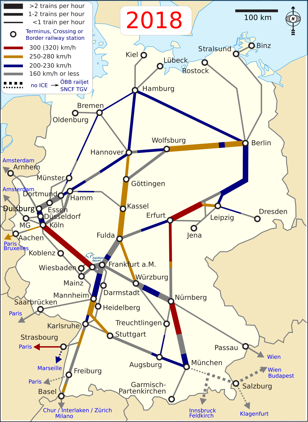
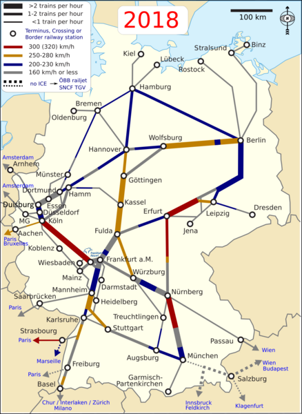
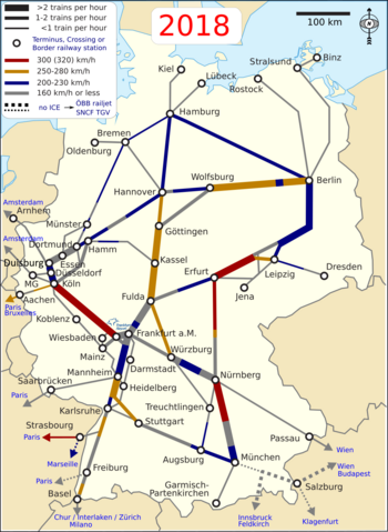
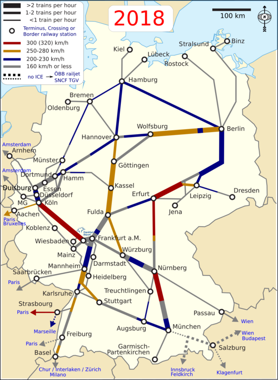
English: Map of the German ICE rail system, showing long-distance rail lines served by ICE trains. Shown are not connections but rather the used capacity and maximum speed of all sections. The map does include official ICE lines exclusively served by ÖBB railjet, the SBB ECE and by the SNCF TGV. Deutsch: Karte des deutschen Fernbahnnetzes mit einer Bedienung durch ICE-Züge. Eingezeichnet sind nicht die Verbindungen, sondern Taktfrequenzen und zulässige Höchstgeschwindigkeiten. Die Karte enthält auch offizielle ICE-Linien, die ausschließlich mit dem SNCF TGV, dem neuen SBB ECE und vom ÖBB railjet bedient werden. |
| Date | |
| Source | Own work |
| Author | Classical geographer |
| Other versions | ICEtracks.svg (original SVG-version) |
Background is  .
.
North Arrow is also a Commons image. Information is a combination of File:ICE Network.png and the DB ICE network map archive copy at the Wayback Machine (This last file changes location often; a permanent pointer is available at de:Vorlage:DBAG-ICE-Netzplan-URL).
Licensing
[edit]
I, the copyright holder of this work, hereby publish it under the following licenses:
This file is licensed under the Creative Commons Attribution-Share Alike 3.0 Unported license.
- You are free:
- to share – to copy, distribute and transmit the work
- to remix – to adapt the work
- Under the following conditions:
- attribution – You must give appropriate credit, provide a link to the license, and indicate if changes were made. You may do so in any reasonable manner, but not in any way that suggests the licensor endorses you or your use.
- share alike – If you remix, transform, or build upon the material, you must distribute your contributions under the same or compatible license as the original.

|
Permission is granted to copy, distribute and/or modify this document under the terms of the GNU Free Documentation License, Version 1.2 or any later version published by the Free Software Foundation; with no Invariant Sections, no Front-Cover Texts, and no Back-Cover Texts. A copy of the license is included in the section entitled GNU Free Documentation License. |
You may select the license of your choice.
File history
Click on a date/time to view the file as it appeared at that time.
| Date/Time | Thumbnail | Dimensions | User | Comment | |
|---|---|---|---|---|---|
| current | 00:21, 3 January 2020 | | 1,052 × 1,441 (458 KB) | Spazzo (talk | contribs) | Duisburg added. |
| 12:02, 19 December 2017 |  | 1,052 × 1,441 (470 KB) | Metrancya (talk | contribs) | small correction | |
| 11:45, 19 December 2017 |  | 1,052 × 1,441 (470 KB) | Metrancya (talk | contribs) | Further corrections. Traffic to Amsterdam will often run through Möcnchengladbach, Venlo, Eindhoven. Corrections around jena and Nuremberg. | |
| 11:26, 13 December 2017 |  | 1,052 × 1,441 (464 KB) | Metrancya (talk | contribs) | use of wikimedia fonts | |
| 23:08, 12 December 2017 |  | 1,119 × 1,525 (492 KB) | Metrancya (talk | contribs) | final changes | |
| 22:57, 12 December 2017 |  | 1,119 × 1,525 (492 KB) | Metrancya (talk | contribs) | more changes | |
| 21:39, 12 December 2017 |  | 1,108 × 1,502 (490 KB) | Metrancya (talk | contribs) | small corrections around Wiesbaden-frankfurt-karlsruhe-Stuttgart | |
| 07:12, 9 December 2017 |  | 1,108 × 1,502 (550 KB) | Metrancya (talk | contribs) | ICE logo removed as the "ICE network" is also used by railjet, TGV, ECE, Thalys. Colors adjusted to fit common sense. | |
| 15:55, 8 December 2017 |  | 1,108 × 1,502 (547 KB) | Metrancya (talk | contribs) | minor changes | |
| 00:17, 8 December 2017 |  | 1,108 × 1,502 (548 KB) | Metrancya (talk | contribs) | minor changes |
You cannot overwrite this file.
File usage on Commons
The following 31 pages use this file:
- German locomotives
- User:Chumwa/OgreBot/Potential transport maps/2016 December 1-10
- User:Chumwa/OgreBot/Potential transport maps/2016 December 11-20
- User:Chumwa/OgreBot/Potential transport maps/2016 December 21-31
- User:Chumwa/OgreBot/Potential transport maps/2017 December 1-10
- User:Chumwa/OgreBot/Potential transport maps/2017 December 11-20
- User:Chumwa/OgreBot/Potential transport maps/2020 January 1-10
- User:Chumwa/OgreBot/Public transport information/2015 September 11-20
- User:Chumwa/OgreBot/Public transport information/2016 December 1-10
- User:Chumwa/OgreBot/Public transport information/2016 December 11-20
- User:Chumwa/OgreBot/Public transport information/2016 December 21-31
- User:Chumwa/OgreBot/Public transport information/2016 January 1-10
- User:Chumwa/OgreBot/Public transport information/2017 December 1-10
- User:Chumwa/OgreBot/Public transport information/2017 December 11-20
- User:Chumwa/OgreBot/Public transport information/2020 January 1-10
- User:Chumwa/OgreBot/Transport Maps/2015 September 11-20
- User:Chumwa/OgreBot/Transport Maps/2016 December 1-10
- User:Chumwa/OgreBot/Transport Maps/2016 December 11-20
- User:Chumwa/OgreBot/Transport Maps/2016 December 21-31
- User:Chumwa/OgreBot/Transport Maps/2016 January 1-10
- User:Chumwa/OgreBot/Transport Maps/2017 December 1-10
- User:Chumwa/OgreBot/Transport Maps/2017 December 11-20
- User:Chumwa/OgreBot/Transport Maps/2020 January 1-10
- User:Chumwa/OgreBot/Travel and communication maps/2016 December 1-10
- User:Chumwa/OgreBot/Travel and communication maps/2016 December 11-20
- User:Chumwa/OgreBot/Travel and communication maps/2016 December 21-31
- User:Chumwa/OgreBot/Travel and communication maps/2017 December 1-10
- User:Chumwa/OgreBot/Travel and communication maps/2017 December 11-20
- User:Classical geographer
- User:Nordlicht8/Rail Germany/2015 September 11-20
- User:Nordlicht8/Rail Germany/2016 January 1-10
File usage on other wikis
The following other wikis use this file:
- Usage on de.wikibooks.org
- Usage on en.wikipedia.org
- Usage on en.wikivoyage.org
- Usage on hu.wikipedia.org
- Usage on nl.wikipedia.org
- Usage on pl.wikivoyage.org
- Usage on pt.wikipedia.org