File:Ireland-CIA WFB Map.png
Jump to navigation
Jump to search
No higher resolution available.
Ireland-CIA_WFB_Map.png (330 × 355 pixels, file size: 12 KB, MIME type: image/png)
Captions
Captions
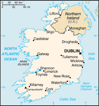
Map of Republic of Ireland major towns
| Description |
English: A map of Ireland, showing major towns. |
|||
| Date | published 2004 | |||
| Source | CIA, The World Factbook, 2004. | |||
| Author | CIA | |||
| Permission (Reusing this file) |
|


|
File:Ei-map.svg is a vector version of this file. It should be used in place of this PNG file when not inferior.
File:Ireland-CIA WFB Map.png → File:Ei-map.svg
For more information, see Help:SVG. |
 |
File history
Click on a date/time to view the file as it appeared at that time.
| Date/Time | Thumbnail | Dimensions | User | Comment | |
|---|---|---|---|---|---|
| current | 09:14, 27 March 2005 | | 330 × 355 (12 KB) | Wolfman~commonswiki (talk | contribs) | {{CIA-map}} |
You cannot overwrite this file.
File usage on Commons
There are no pages that use this file.
File usage on other wikis
The following other wikis use this file:
- Usage on ast.wikipedia.org
- Usage on ca.wikipedia.org
- Usage on el.wikipedia.org
- Usage on gom.wikipedia.org
- Usage on ilo.wikipedia.org
- Usage on ja.wikipedia.org
- Usage on kn.wikipedia.org
- Usage on mdf.wikipedia.org
- Usage on ml.wikipedia.org
- Usage on sh.wikipedia.org
- Usage on simple.wikipedia.org
- Usage on sl.wikipedia.org
- Usage on th.wikipedia.org
- Usage on uz.wikipedia.org
- Usage on zh-min-nan.wikipedia.org
- Usage on zh.wikipedia.org