File:Irish Sea location map.svg
Jump to navigation
Jump to search

Size of this PNG preview of this SVG file: 305 × 397 pixels. Other resolutions: 184 × 240 pixels | 369 × 480 pixels | 590 × 768 pixels | 787 × 1,024 pixels | 1,573 × 2,048 pixels.
Original file (SVG file, nominally 305 × 397 pixels, file size: 824 KB)
Captions
Captions
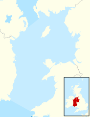
Map of the Irish Sea
Summary
[edit]
| Description |
English: Location map of the Irish Sea. The boundaries, indicated by the slightly darker blue areas, are those of the International Hydrographic Organization.[1] Other organisations may include the North Channel to the north.
Equirectangular projection, N/S stretching 170 %. Geographic limits of the map:
|
| Date | |
| Source |
This file was derived from: United Kingdom location map.svg:  |
| Author |
|
Licensing
[edit]
This file is licensed under the Creative Commons Attribution-Share Alike 4.0 International license.
Attribution: NordNordWest and Dr Greg
- You are free:
- to share – to copy, distribute and transmit the work
- to remix – to adapt the work
- Under the following conditions:
- attribution – You must give appropriate credit, provide a link to the license, and indicate if changes were made. You may do so in any reasonable manner, but not in any way that suggests the licensor endorses you or your use.
- share alike – If you remix, transform, or build upon the material, you must distribute your contributions under the same or compatible license as the original.
References
[edit]
- ↑ Limits of Oceans and Seas, 3rd edition 12 & 39. International Hydrographic Organization (1953). Retrieved on 20 July 2024.
File history
Click on a date/time to view the file as it appeared at that time.
| Date/Time | Thumbnail | Dimensions | User | Comment | |
|---|---|---|---|---|---|
| current | 16:41, 19 July 2024 | | 305 × 397 (824 KB) | Dr Greg (talk | contribs) | Uploaded own work with UploadWizard |
You cannot overwrite this file.
File usage on Commons
There are no pages that use this file.
File usage on other wikis
The following other wikis use this file:
- Usage on en.wikipedia.org