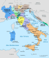
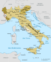
File:Italy 1796 AD-it.png
From Wikimedia Commons, the free media repository
(Redirected from File:Italia 1796.png)

Size of this preview: 421 × 600 pixels. Other resolutions: 168 × 240 pixels | 337 × 480 pixels | 767 × 1,093 pixels.
Original file (767 × 1,093 pixels, file size: 231 KB, MIME type: image/png)
File information
Structured data
Captions
Captions
Add a one-line explanation of what this file represents
Summary
[edit]| DescriptionItaly 1796 AD-it.png |
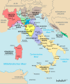
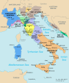
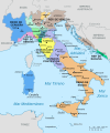
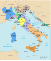
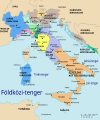
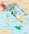
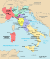
English: A political map of Italy in early 1796, before the Napoleonic wars, created by MapMaster.
This is a companion map to Image:Italy 1000 AD.svg, Image:Italy 1494 v2.png, and Image:Italy c 1810.png. This map uses a modified Mercator projection. |
| Date | 28 February 2007 (original upload date) |
| Source | No machine-readable source provided. Own work assumed (based on copyright claims). |
| Author | No machine-readable author provided. MapMaster assumed (based on copyright claims). |
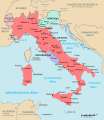
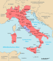
| Other versions |
[edit]
|
References
[edit]- Bjorklund, Oddvar; Holmboe, Haakon; Rohr, Anders (1970) Historical Atlas of the World, Barnes & Noble, NY, SBN: 389-00253-4.
- Other maps, including Image:Italy 1796.jpg from the Historical Atlas by William R. Shepherd, 1926.
Licensing
[edit]I, the copyright holder of this work, hereby publish it under the following license:

|
Permission is granted to copy, distribute and/or modify this document under the terms of the GNU Free Documentation License, Version 1.2 or any later version published by the Free Software Foundation; with no Invariant Sections, no Front-Cover Texts, and no Back-Cover Texts. A copy of the license is included in the section entitled GNU Free Documentation License.http://www.gnu.org/copyleft/fdl.htmlGFDLGNU Free Documentation Licensetruetrue |
| This file is licensed under the Creative Commons Attribution-Share Alike 3.0 Unported license. | ||
| ||
| This licensing tag was added to this file as part of the GFDL licensing update.http://creativecommons.org/licenses/by-sa/3.0/CC BY-SA 3.0Creative Commons Attribution-Share Alike 3.0truetrue |
derivative works
[edit]Derivative works of this file: Italia 1796.svg
File history
Click on a date/time to view the file as it appeared at that time.
| Date/Time | Thumbnail | Dimensions | User | Comment | |
|---|---|---|---|---|---|
| current | 20:24, 2 March 2007 |  | 767 × 1,093 (231 KB) | MapMaster (talk | contribs) | Modification based on suggestions from User:Paolo da Reggio |
| 17:40, 28 February 2007 |  | 767 × 1,093 (231 KB) | MapMaster (talk | contribs) | A map of Italy, in Italian, in 1796. |
You cannot overwrite this file.
File usage on Commons
The following 43 pages use this file:
- Maps of the Italian Risorgimento
- File:Italia 1796-ca.svg
- File:Italia 1796-es.svg
- File:Italia 1796-fr.svg
- File:Italia 1796.png (file redirect)
- File:Italy 1796 AD.png
- File:Italy 1796 AD-it.png
- Category talk:Grand Duchy of Tuscany
- File:Italy 1796 AD-sv.png
- Maps of the Italian Risorgimento
- File:Italy and Illyria 1084 AD-it.svg
- File:Italy 1796 heb.jpg
- File:Italia 1796.svg
- File:Italia 1796 - HE.svg
- File:Italy 1796 AD-ar.png
- File:Italia 1796-es.svg
- File:Italy 1796.svg
- File:Italia 1796-fr.svg
- File:Italy 1796 de.svg
- File:Italy 1796 it.svg
- File:Italy 1796 AD-el.png
- File:Italy 1796 AD-ko.png
- Template:Other versions/Italy 1796 AD
- File:Italy 1796-hu.svg
- File:Italia 1796-ca.svg
- File:Italy 1796 AD-ca.svg
- File:Italia 1796.svg
- File:Italia 1796 - HE.svg
- File:Italy 1796-hu.svg
- File:Italy 1796.svg
- File:Italy 1796 AD-ar.png
- File:Italy 1796 AD-ca.svg
- File:Italy 1796 AD-el.png
- File:Italy 1796 AD-it.png
- File:Italy 1796 AD-ko.png
- File:Italy 1796 AD-sv.png
- File:Italy 1796 AD.png
- File:Italy 1796 de.svg
- File:Italy 1796 heb.jpg
- File:Italy 1796 it.svg
- File:Italy and Illyria 1084 AD-it.svg
- Template:Other versions/Italy 1796 AD
- Category talk:Grand Duchy of Tuscany
File usage on other wikis
The following other wikis use this file:
- Usage on als.wikipedia.org
- Usage on bar.wikipedia.org
- Usage on bg.wikipedia.org
- Usage on br.wikipedia.org
- Usage on de.wikipedia.org
- Usage on es.wikipedia.org
- Usage on et.wikipedia.org
- Usage on eu.wikipedia.org
- Usage on fr.wikipedia.org
- Usage on gl.wikipedia.org
- Usage on hr.wikipedia.org
- Usage on hu.wikipedia.org
- Usage on it.wikipedia.org
- Risorgimento
- Utente:MapMaster
- Utente:Tizio X/Sandbox3
- Storia d'Italia
- Storia della Repubblica di Venezia
- Massacri delle foibe
- Esodo giuliano dalmata
- Stati italiani nella prima metà del XVIII secolo
- Utente:Francesco Ippolito/Libri/Italia
- Questione adriatica
- Portale:Risorgimento
- Portale:Risorgimento/Mappe
- Benzani
- Utente:Barjimoa/Sandbox
- Usage on ja.wikipedia.org
- Usage on nn.wikipedia.org
- Usage on pl.wikipedia.org
- Usage on pt.wikipedia.org
- Usage on scn.wikipedia.org
- Usage on sr.wikipedia.org
- Usage on uk.wikipedia.org
- Usage on zh-min-nan.wikipedia.org
Structured data
Items portrayed in this file
depicts
28 February 2007
236,101 byte
1,093 pixel
767 pixel
image/png
4613de5b67ab9dc91a278de31e146be9ca04df9f
Categories:
- 1796 in Italy
- 1796 maps of Europe
- Maps of the history of the Italian Peninsula
- Maps of historical states of Italy
- Maps of the Republic of Venice
- Maps of Italy in the 18th century
- Maps of the Republic of Genoa
- Kingdom of Sardinia
- Maps of the history of Sardinia
- Maps of the Grand Duchy of Tuscany
- Maps of the Republic of Lucca
- Maps of the Duchy of Parma and Piacenza
- Maps of Duchy of Modena and Reggio
- Maps of the Papal States
- 1796 in the Papal States
- Maps of the Kingdom of Sicily


