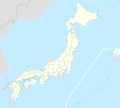
File:Japan location map with side map of the Ryukyu Islands.svg

Original file (SVG file, nominally 413 × 373 pixels, file size: 980 KB)
Captions
Captions
Summary
[edit]| DescriptionJapan location map with side map of the Ryukyu Islands.svg |
Deutsch: Postionskarte von Japan
Quadratische Plattkarte. Bei Nutzung der Hauptkarte mit den Hauptinseln gelten folgende geographische Begrenzungen für die (Gesamt-)Karte:
Bei Nutzung der Nebenkarte mit den Ryūkyū-Inseln gelten folgende geographische Begrenzungen für die (Gesamt-)Karte:
English: Location map of Japan
Equirectangular projection. Geographic limits to locate objects in the main map with the main islands:
Geographic limits to locate objects in the side map with the Ryukyu Islands:
日本語: 日本国の地図。
正距円筒図法。 南西諸島以外の日本を描いたメインの地図が示す領域:
南西諸島を描いた右下の地図が示す領域:
|
||
| Date | |||
| Source | Own work | ||
| Author | Maximilian Dörrbecker (Chumwa) | ||
| Permission (Reusing this file) |
I, the copyright holder of this work, hereby publish it under the following licenses:
This file is licensed under the Creative Commons Attribution-Share Alike 3.0 Unported license.
You may select the license of your choice. |
||
| Other versions |
Derivative works of this file: |
||
| SVG development InfoField | This map was created with Adobe Illustrator.
|
File history
Click on a date/time to view the file as it appeared at that time.
| Date/Time | Thumbnail | Dimensions | User | Comment | |
|---|---|---|---|---|---|
| current | 14:21, 3 April 2022 |  | 413 × 373 (980 KB) | Peka (talk | contribs) | Reverted to version as of 10:18, 10 August 2021; no discuss about this change |
| 10:18, 10 August 2021 |  | 413 × 373 (1.56 MB) | Jeebeen (talk | contribs) | Liancourts Rock isn't territory of Japan | |
| 05:19, 14 November 2020 |  | 413 × 373 (980 KB) | AichiWikiFixer (talk | contribs) | Fix borders. | |
| 13:53, 30 October 2010 |  | 413 × 373 (926 KB) | NordNordWest (talk | contribs) | Liancourts Rock boundary | |
| 01:15, 17 September 2010 |  | 413 × 373 (1.56 MB) | Dinamik (talk | contribs) | medium color for disputed territories | |
| 11:41, 21 March 2010 |  | 413 × 373 (1.52 MB) | Chumwa (talk | contribs) | Präfekturgrenzen bereinigt | |
| 13:33, 20 March 2010 |  | 413 × 373 (1.71 MB) | Chumwa (talk | contribs) | Trennlinie zu Nebenkarte etwas verbreitert | |
| 09:50, 20 March 2010 |  | 413 × 373 (1.92 MB) | Chumwa (talk | contribs) | == {{int:filedesc}} == {{Information |Description= {{de|Postionskarte von Japan}} Quadratische Plattkarte. Bei Nutzung der Hauptkarte mit den Hauptinseln gelten folgende geographische Begrenzungen für die (Gesamt-)Karte: * N: 45°51'37" N |
You cannot overwrite this file.
File usage on Commons
More than 100 pages use this file. The following list shows the first 100 pages that use this file only. A full list is available.
- File:Aichi in Japan.svg
- File:Aichi in Japan (extended).svg
- File:Akita in Japan.svg
- File:Akita in Japan (extended).svg
- File:Aomori in Japan.svg
- File:Aomori in Japan (extended).svg
- File:Chiba in Japan.svg
- File:Chiba in Japan (extended).svg
- File:Ehime in Japan.svg
- File:Ehime in Japan (extended).svg
- File:Fukui in Japan.svg
- File:Fukui in Japan (extended).svg
- File:Fukuoka in Japan.svg
- File:Fukuoka in Japan (extended).svg
- File:Fukushima in Japan.svg
- File:Fukushima in Japan (extended).svg
- File:Gifu in Japan.svg
- File:Gifu in Japan (extended).svg
- File:Gunma in Japan.svg
- File:Gunma in Japan (extended).svg
- File:Hiroshima in Japan.svg
- File:Hiroshima in Japan (extended).svg
- File:Hokkaido in Japan (claimed).svg
- File:Hokkaido in Japan (claimed) (extended).svg
- File:Hokkaido in Japan (claimed hatched).svg
- File:Hokkaido in Japan (claimed hatched) (extended).svg
- File:Hokkaido in Japan (de-facto).svg
- File:Hokkaido in Japan (de-facto) (extended).svg
- File:Hyogo in Japan.svg
- File:Hyogo in Japan (extended).svg
- File:Ibaraki in Japan.svg
- File:Ibaraki in Japan (extended).svg
- File:Ishikawa in Japan.svg
- File:Ishikawa in Japan (extended).svg
- File:Iwate in Japan.svg
- File:Iwate in Japan (extended).svg
- File:JAPAN EARTHQUAKE 20110311-cs.png
- File:JAPAN EARTHQUAKE 20110311-rm.png
- File:JAPAN EARTHQUAKE 20110311.png
- File:Japan bluemarble location map with side map of the Ryukyu Islands.jpg
- File:Japan location map.svg
- File:Japan natural location map with side map of the Ryukyu Islands.jpg
- File:Kagawa in Japan.svg
- File:Kagawa in Japan (extended).svg
- File:Kagoshima in Japan.svg
- File:Kagoshima in Japan (extended).svg
- File:Kanagawa in Japan.svg
- File:Kanagawa in Japan (extended).svg
- File:Kochi in Japan.svg
- File:Kochi in Japan (extended).svg
- File:Kumamoto in Japan.svg
- File:Kumamoto in Japan (extended).svg
- File:Kyoto in Japan.svg
- File:Kyoto in Japan (extended).svg
- File:Mie in Japan.svg
- File:Mie in Japan (extended).svg
- File:Miyagi in Japan.svg
- File:Miyagi in Japan (extended).svg
- File:Miyazaki in Japan.svg
- File:Miyazaki in Japan (extended).svg
- File:Nagano in Japan.svg
- File:Nagano in Japan (extended).svg
- File:Nagasaki in Japan.svg
- File:Nagasaki in Japan (extended).svg
- File:Nara in Japan.svg
- File:Nara in Japan (extended).svg
- File:Niigata in Japan.svg
- File:Niigata in Japan (extended).svg
- File:Npb teams map.svg
- File:Oita in Japan.svg
- File:Oita in Japan (extended).svg
- File:Okayama in Japan.svg
- File:Okayama in Japan (extended).svg
- File:Okinawa in Japan.svg
- File:Okinawa in Japan (extended).svg
- File:Osaka in Japan.svg
- File:Osaka in Japan (extended).svg
- File:Saga in Japan.svg
- File:Saga in Japan (extended).svg
- File:Saitama in Japan.svg
- File:Saitama in Japan (extended).svg
- File:Shiga in Japan.svg
- File:Shiga in Japan (extended).svg
- File:Shimane in Japan (claimed).svg
- File:Shimane in Japan (claimed) (extended).svg
- File:Shimane in Japan (de-facto).svg
- File:Shimane in Japan (de-facto) (extended).svg
- File:Shizuoka in Japan.svg
- File:Shizuoka in Japan (extended).svg
- File:Tochigi in Japan.svg
- File:Tochigi in Japan (extended).svg
- File:Tokushima in Japan.svg
- File:Tokushima in Japan (extended).svg
- File:Tokyo in Japan.svg
- File:Tokyo in Japan (extended).svg
- File:Tottori in Japan.svg
- File:Tottori in Japan (extended).svg
- File:Toyama in Japan.svg
- File:Toyama in Japan (extended).svg
- File:Wakayama in Japan.svg
View more links to this file.
File usage on other wikis
The following other wikis use this file:
- Usage on ace.wikipedia.org
- Usage on af.wikipedia.org
- Osaka
- Hirosjima
- Tokio
- Nara, Nara
- Kioto
- Nagasaki
- Jokohama
- Nagoja
- Sapporo
- Kobe
- Nagano
- FIFA Sokker-Konfederasiebeker in 2001
- Nanao
- Rugbywêreldbeker 2019
- Fukuoka
- Kawasaki
- Saitama
- Sendai
- Kitakyushu
- Chiba
- Tokio-Haneda Internasionale Lughawe
- Narita Internasionale Lughawe
- Kansai Internasionale Lughawe
- Toyota, Aichi
- Groep van Sewe
- Saga (stad)
- Usage on als.wikipedia.org
- Usage on an.wikipedia.org
- Usage on ar.wikipedia.org
View more global usage of this file.
Metadata
This file contains additional information such as Exif metadata which may have been added by the digital camera, scanner, or software program used to create or digitize it. If the file has been modified from its original state, some details such as the timestamp may not fully reflect those of the original file. The timestamp is only as accurate as the clock in the camera, and it may be completely wrong.
| Width | 413.131px |
|---|---|
| Height | 373.294px |


