File:John-Tallis-1851-Tibet-Mongolia-and-Manchuria-33621.jpg
Jump to navigation
Jump to search
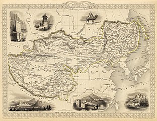
Size of this preview: 779 × 600 pixels. Other resolutions: 312 × 240 pixels | 624 × 480 pixels | 998 × 768 pixels | 1,280 × 985 pixels | 2,560 × 1,971 pixels | 4,030 × 3,102 pixels.
Original file (4,030 × 3,102 pixels, file size: 12.64 MB, MIME type: image/jpeg)
Captions
Captions
Add a one-line explanation of what this file represents
Summary
[edit]
| Description |
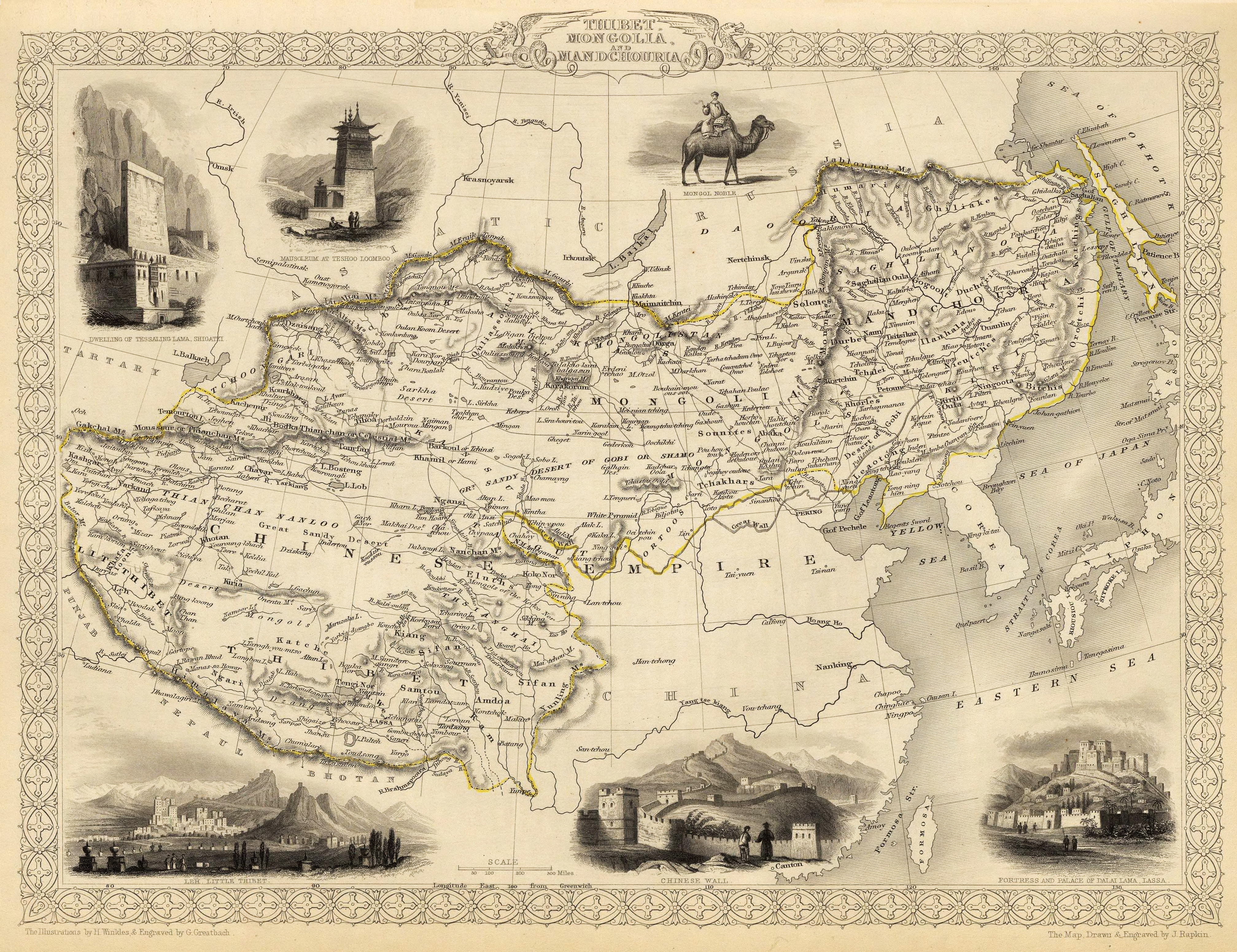
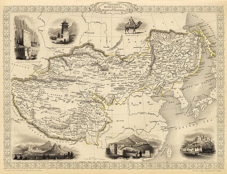
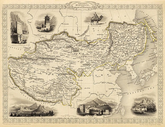
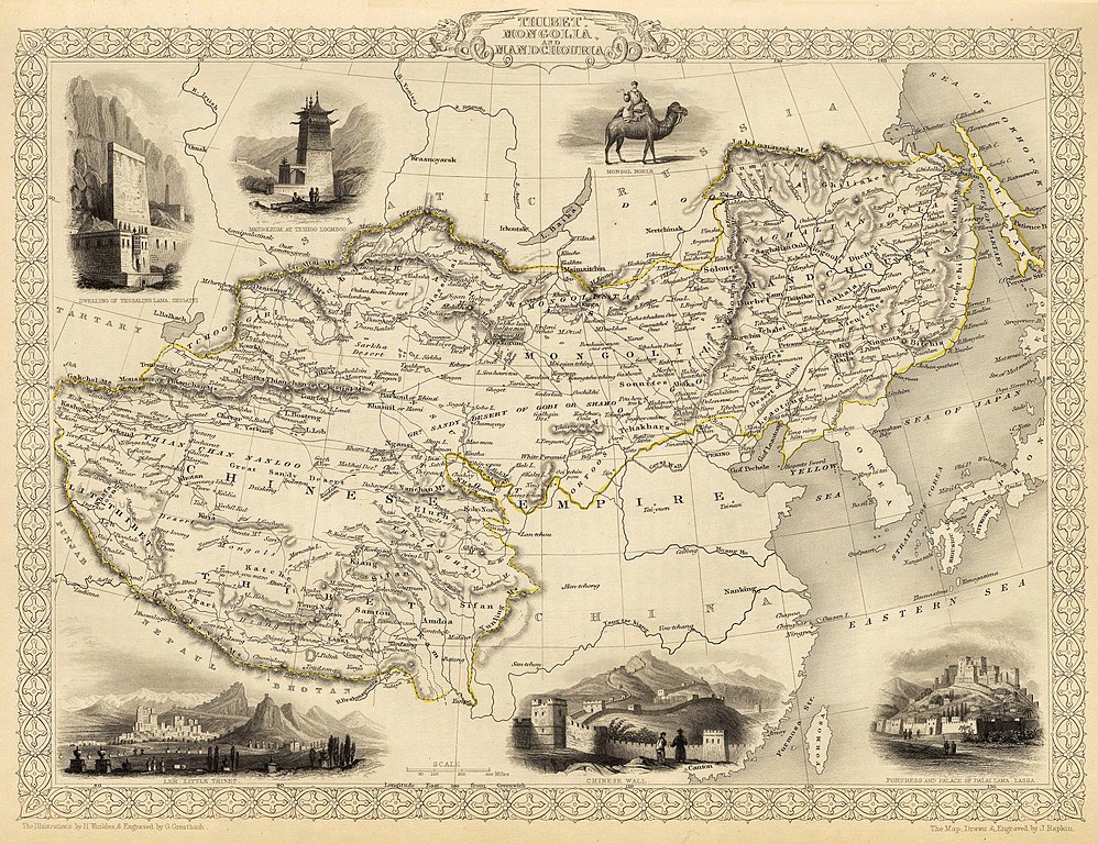
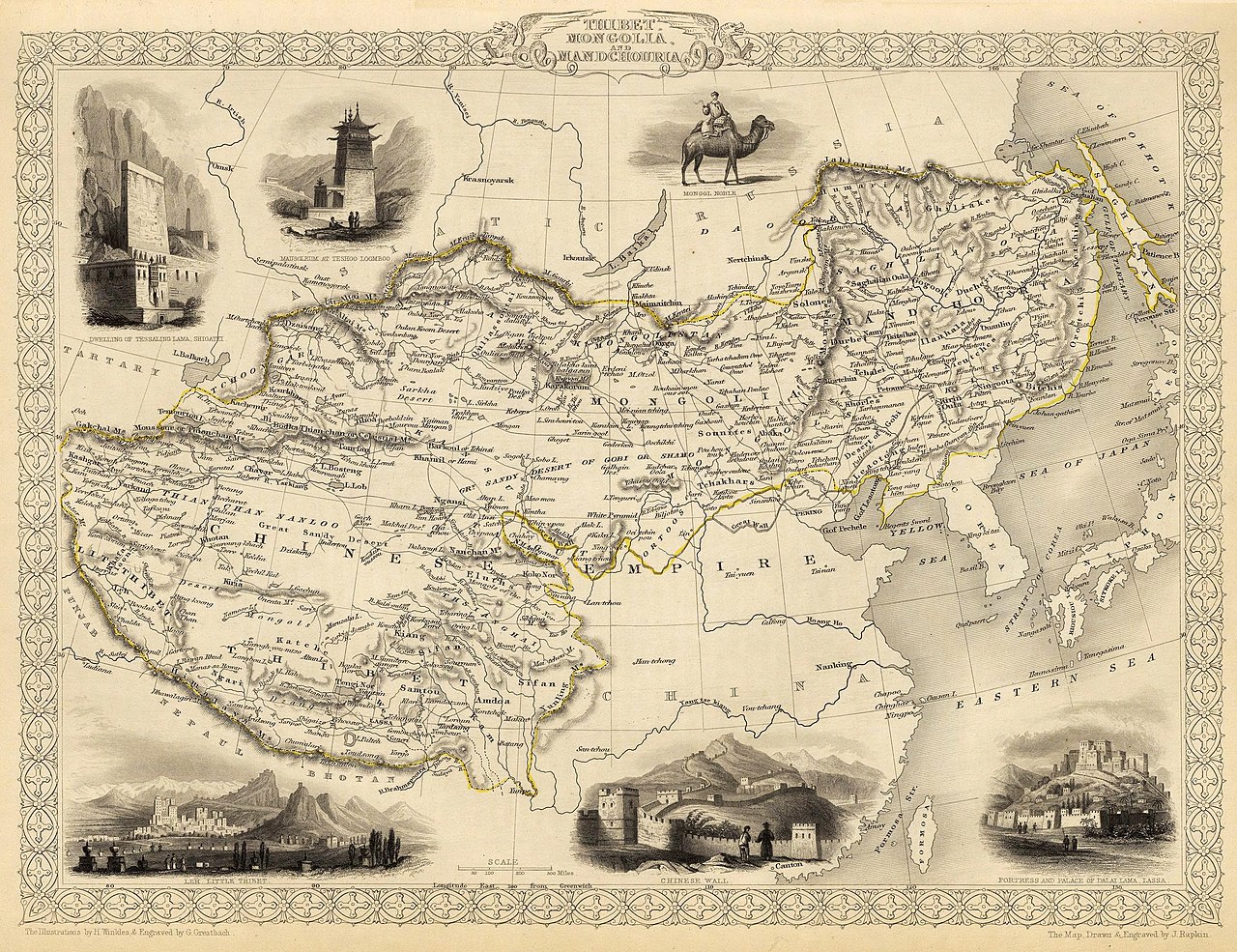
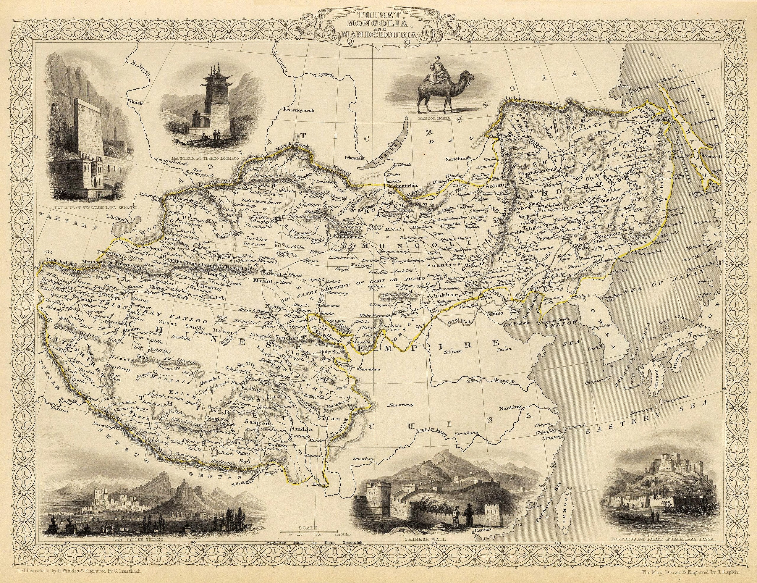
English: Map of the northern and western part of the Chinese Empire - "Thibet, Mongolia, and Mandchouria". The borders are shown as per the 1686 Treaty of Nerchinsk. (They were to be changed drastically in 1858-60, by treaty of Aigun and subsequent agreements). The main Russian center in Transbaikalia is still Nerchinsk, rather than Chita. The outline of Sakhalin Island is already shown fairly correctly, but the body of water separating it from the mainland is still labeled "Gulf of Tartary" (rather than '"Strait).
Français : Carte des parties Nord et Ouest de l'Empire chinois — « Thibet, Mongolie and Mandchourie ». Les frontières sont montrées telles qu'elles étaient définies par le Traité de Nerchinsk de 1686. (Elles allaient être grandement changées en 1858-1860 par le traité d'Aigun et les accords suivants). Le principal centre russe en Transbaïkalie est encore Nerchinsk, plutôt que Chita. Le contour de l'île Sakhaline est déjà décrit très correctement, mais l'étendue d'eau la séparant du continent est encore qualifiée de « golfe de Tartarie » (plutôt que « détroit »).
中文:中国皇国,北部和西部。 |
| Date | |
| Source | John Tallis' atlas of the world. Reproduced at http://www.davidrumsey.com/luna/servlet/detail/RUMSEY~8~1~821~60126:Thibet,-Mongolia,-and-Mandchouria-- (the last version uploaded is from there), http://www.jpmaps.co.uk/mapimages/originals/33621.jpg , and elsewhere |
| Author | Martin, R.M.; Tallis, J. & F. The staff of John Tallis: The Illustrations by H. Winkles & Engraved by G. Greatbach. The Map Drawn & Engraved by J. Rapkin. |
| Other versions | Derivative works of this file: John-Tallis-1851-Tibet-Mongolia-and-Manchuria-NE.jpg |
Licensing
[edit]
|
This work is in the public domain in its country of origin and other countries and areas where the copyright term is the author's life plus 70 years or fewer. | |
| This file has been identified as being free of known restrictions under copyright law, including all related and neighboring rights. | |
File history
Click on a date/time to view the file as it appeared at that time.
| Date/Time | Thumbnail | Dimensions | User | Comment | |
|---|---|---|---|---|---|
| current | 20:51, 28 February 2016 | | 4,030 × 3,102 (12.64 MB) | Centpacrr (talk | contribs) | Crop |
| 02:26, 7 December 2009 |  | 4,700 × 3,750 (4.07 MB) | Vmenkov (talk | contribs) | better resolution, as available from http://www.davidrumsey.com/luna/servlet/detail/RUMSEY~8~1~821~60126:Thibet,-Mongolia,-and-Mandchouria-- | |
| 01:38, 7 December 2009 |  | 1,289 × 989 (386 KB) | Vmenkov (talk | contribs) | {{Information |Description={{en|1=Map of the northern and western part of the Chinese Empire - "Thibet, Mongolia, and Mandchouria". The borders are shows as per the 1858 treaty of Aigun. The main Russian center in Transbaikalia is still Nerchinsk, rather |
You cannot overwrite this file.
File usage on Commons
The following 6 pages use this file:
File usage on other wikis
The following other wikis use this file:
- Usage on ar.wikipedia.org
- Usage on el.wikipedia.org
- Usage on en.wikipedia.org
- Usage on fr.wikipedia.org
- Usage on hr.wikipedia.org
- Usage on ko.wikipedia.org
- Usage on mn.wikipedia.org
- Usage on sh.wikipedia.org
- Usage on vi.wikipedia.org
Metadata
Categories:
- 1850s maps of China
- 19th-century maps of Tibet
- 19th-century maps of Mongolia
- 19th-century maps of Manchuria
- Old maps of the Qing Dynasty
- 19th-century maps of Tartary
- Maps by John Tallis
- Maps by Henry Winkles
- Robert Montgomery Martin
- Thangka wall
- Batang
- 1851 in Tibet
- History of Tashilhunpo
- Bactrian camels in art
- Potala Palace in art
- Old maps that include Leh
- 1850s maps of Korea
- Maps by John Rapkin
- Willow Palisade
- Great Wall of China in art
- Treaty of Nerchinsk