File:KERALA MAP.jpg
Jump to navigation
Jump to search

Size of this preview: 358 × 599 pixels. Other resolutions: 143 × 240 pixels | 287 × 480 pixels | 459 × 768 pixels | 612 × 1,024 pixels | 2,050 × 3,431 pixels.
Original file (2,050 × 3,431 pixels, file size: 1,000 KB, MIME type: image/jpeg)
Captions
Captions
Add a one-line explanation of what this file represents
Summary
[edit]
| Description |
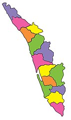
മലയാളം: കേരളത്തിന്റെ പുതിയ ഭൂപടം.ഇടുക്കി ജില്ലയിലെ 543 ചതുരശ്ര കിലോമീറ്റർ വിസ്തീർണ്ണമുള്ള കുട്ടമ്പുഴ പഞ്ചായത്ത് എറണാകുളം ജില്ലയിൽ ചേർത്തശേഷമുള്ള ഭൂപടമാണിത്.ഈ മാറ്റത്തോടെ എറണാകുളം ജില്ലയ്ക്ക് തമിഴ്നാടുമായി അതിർത്തിയുണ്ടായി.2000 ഒക്ടോബർ 2നായിരുന്നു ഈ മാറ്റം. |
| Date | 23 October 2007 (original upload date) |
| Source | Transferred from ml.wikipedia; transferred to Commons by User:Sreejithk2000 using CommonsHelper. |
| Author | Kckkumar at ml.wikipedia |
| Permission (Reusing this file) |
CC-BY-2.5. |
Licensing
[edit]
This file is licensed under the Creative Commons Attribution 2.5 Generic license.
- You are free:
- to share – to copy, distribute and transmit the work
- to remix – to adapt the work
- Under the following conditions:
- attribution – You must give appropriate credit, provide a link to the license, and indicate if changes were made. You may do so in any reasonable manner, but not in any way that suggests the licensor endorses you or your use.
Original upload log
[edit]
The original description page was here. All following user names refer to ml.wikipedia.
- 2007-10-23 11:49 Kckkumar 2050×3431× (1023587 bytes) കേരളത്തിന്റെ പുതിയ ഭൂപടം.ഇടുക്കി ജില്ലയിലെ 543 ചതുരശ്ര കിലോമീറ്റർ വിസ്തീർണ്ണമുള്ള കുട്ടമ
- 2007-10-23 11:27 Kckkumar 2050×3431× (1365253 bytes) കേരളത്തിന്റെ പുതിയ ഭൂപടം.ഇടുക്കി ജില്ലയിലെ 543 ചതുരശ്ര കിലോമീറ്റർ വിസ്തീർണ്ണമുള്ള കുട്ടമ
- 2007-10-23 11:24 Kckkumar 2050×3431× (1353791 bytes) കേരളത്തിന്റെ പുതിയ ഭൂപടം.ഇടുക്കി ജില്ലയിലെ 543 ചതുരശ്ര കിലോമീറ്റർ വിസ്തീർണ്ണമുള്ള കുട്ടമ
File history
Click on a date/time to view the file as it appeared at that time.
| Date/Time | Thumbnail | Dimensions | User | Comment | |
|---|---|---|---|---|---|
| current | 12:53, 1 December 2010 | | 2,050 × 3,431 (1,000 KB) | File Upload Bot (Magnus Manske) (talk | contribs) | {{BotMoveToCommons|ml.wikipedia|year={{subst:CURRENTYEAR}}|month={{subst:CURRENTMONTHNAME}}|day={{subst:CURRENTDAY}}}} {{Information |Description={{ml|കേരളത്തിന്റെ പുതിയ ഭൂപടം.ഇടുക്കി ജില് |
You cannot overwrite this file.
File usage on Commons
There are no pages that use this file.