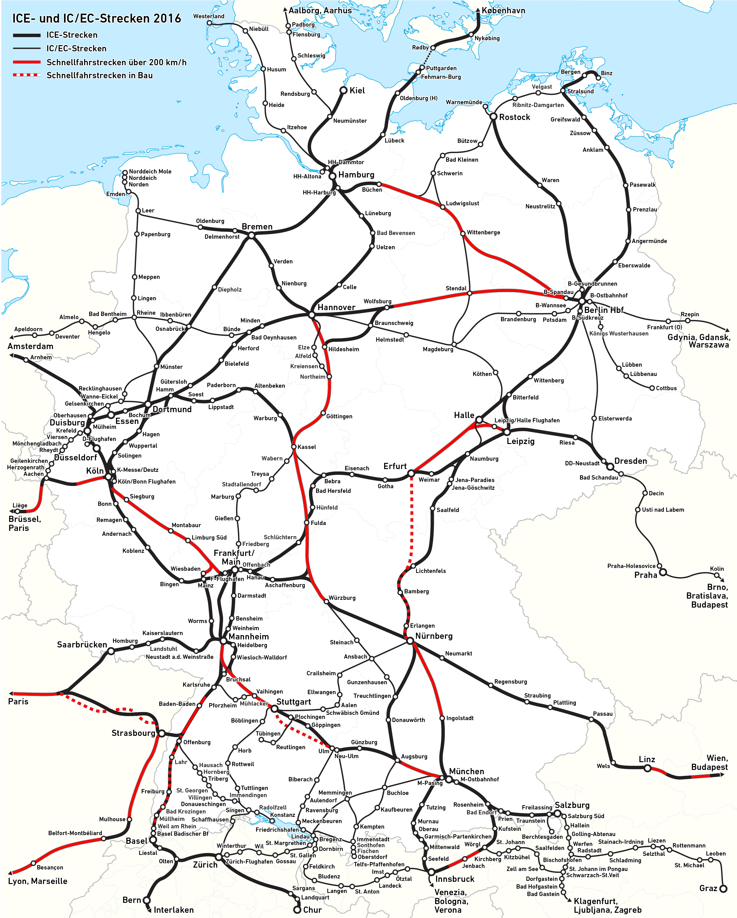
File:Karte IC-, EC- und ICE-Strecken Deutschland.png
Jump to navigation
Jump to search
Size of this preview: 481 × 599 pixels. Other resolutions: 193 × 240 pixels | 385 × 480 pixels | 616 × 768 pixels | 822 × 1,024 pixels | 2,383 × 2,969 pixels.
Original file (2,383 × 2,969 pixels, file size: 1.26 MB, MIME type: image/png)
Captions
Captions
Add a one-line explanation of what this file represents
| Description |
|
||
| Date | see file history | ||
| Source | Own work, using this file by NordNordWest as background | ||
| Author | Maximilian Dörrbecker (Chumwa) | ||
| Permission (Reusing this file) |
I, the copyright holder of this work, hereby publish it under the following license: This file is licensed under the Creative Commons Attribution-Share Alike 2.5 Generic license.
Sie dürfen das Bild zu den folgenden Bedingungen nutzen:
|

See also
[edit]
| See also |
File history
Click on a date/time to view the file as it appeared at that time.
| Date/Time | Thumbnail | Dimensions | User | Comment | |
|---|---|---|---|---|---|
| current | 09:33, 2 September 2020 | | 2,383 × 2,969 (1.26 MB) | Crash48 (talk | contribs) | Name of Gdynia was misspelled |
| 20:15, 7 February 2017 |  | 2,383 × 2,969 (1.21 MB) | Chumwa (talk | contribs) | ||
| 05:23, 30 May 2016 |  | 2,383 × 2,969 (792 KB) | Kopiersperre (talk | contribs) | optipng | |
| 19:01, 28 May 2016 |  | 2,383 × 2,969 (1.21 MB) | Chumwa (talk | contribs) | ||
| 19:20, 5 April 2016 |  | 2,383 × 2,969 (1.21 MB) | Chumwa (talk | contribs) | ||
| 16:44, 4 April 2016 |  | 2,383 × 2,969 (1.21 MB) | Chumwa (talk | contribs) | ||
| 19:05, 29 March 2016 |  | 2,383 × 2,969 (1.21 MB) | Chumwa (talk | contribs) | ||
| 13:51, 25 March 2016 |  | 2,383 × 2,969 (1.2 MB) | Chumwa (talk | contribs) | ||
| 05:50, 21 March 2016 |  | 2,383 × 2,969 (1.2 MB) | Chumwa (talk | contribs) | ||
| 06:13, 20 March 2016 |  | 2,383 × 2,969 (1.2 MB) | Chumwa (talk | contribs) |
You cannot overwrite this file.
File usage on Commons
The following 38 pages use this file:
- User:Chumwa/Gallery
- User:Chumwa/OgreBot/Potential transport maps/2016 April 1-10
- User:Chumwa/OgreBot/Potential transport maps/2016 March 11-20
- User:Chumwa/OgreBot/Potential transport maps/2016 March 21-31
- User:Chumwa/OgreBot/Potential transport maps/2016 May 21-31
- User:Chumwa/OgreBot/Potential transport maps/2017 February 1-9
- User:Chumwa/OgreBot/Public transport information/2016 April 1-10
- User:Chumwa/OgreBot/Public transport information/2016 March 1-10
- User:Chumwa/OgreBot/Public transport information/2016 March 11-20
- User:Chumwa/OgreBot/Public transport information/2016 March 21-31
- User:Chumwa/OgreBot/Public transport information/2016 May 21-31
- User:Chumwa/OgreBot/Public transport information/2017 February 1-9
- User:Chumwa/OgreBot/Public transport information/2020 September 1-10
- User:Chumwa/OgreBot/Transport Maps/2016 April 1-10
- User:Chumwa/OgreBot/Transport Maps/2016 March 1-10
- User:Chumwa/OgreBot/Transport Maps/2016 March 11-20
- User:Chumwa/OgreBot/Transport Maps/2016 March 21-31
- User:Chumwa/OgreBot/Transport Maps/2016 May 21-31
- User:Chumwa/OgreBot/Transport Maps/2017 February 1-9
- User:Chumwa/OgreBot/Transport Maps/2020 September 1-10
- User:Chumwa/OgreBot/Travel and communication maps/2016 April 1-10
- User:Chumwa/OgreBot/Travel and communication maps/2016 March 1-10
- User:Chumwa/OgreBot/Travel and communication maps/2016 March 11-20
- User:Chumwa/OgreBot/Travel and communication maps/2016 March 21-31
- User:Chumwa/OgreBot/Travel and communication maps/2016 May 21-31
- User:Chumwa/OgreBot/Travel and communication maps/2017 February 1-9
- User:Chumwa/Railway maps
- User:Nordlicht8/Rail Germany/2016 April 1-10
- User:Nordlicht8/Rail Germany/2016 March 1-10
- User:Nordlicht8/Rail Germany/2016 March 11-20
- User:Nordlicht8/Rail Germany/2016 March 21-31
- User:Nordlicht8/Rail Germany/2016 May 21-31
- User:Nordlicht8/Rail Germany/2020 September 1-10
- File:Germany - ICE line network, train frequencies and top speeds.svg
- File:ICE-Linien in Österreich.png
- File:ICE Network.png
- File:ICEtracks.svg
- Category:InterCity (Germany)
File usage on other wikis
The following other wikis use this file:
- Usage on de.wikipedia.org
- Usage on de.wikivoyage.org
- Usage on hu.wikipedia.org
- Usage on www.wikidata.org