File:Karte Madagaskar MKL1888.png
Jump to navigation
Jump to search
Size of this preview: 296 × 600 pixels. Other resolutions: 118 × 240 pixels | 354 × 717 pixels.
Original file (354 × 717 pixels, file size: 108 KB, MIME type: image/png)
Captions
Captions
Add a one-line explanation of what this file represents
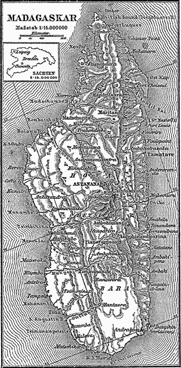
1888 map of Madagascar
| This image comes from the 4th edition of Meyers Konversationslexikon (1885–90). The copyrights have expired and this image is in the public domain. |
|
This work is in the public domain in its country of origin and other countries and areas where the copyright term is the author's life plus 100 years or fewer. This work is in the public domain in the United States because it was published (or registered with the U.S. Copyright Office) before January 1, 1929. | |
| This file has been identified as being free of known restrictions under copyright law, including all related and neighboring rights. | |
File history
Click on a date/time to view the file as it appeared at that time.
| Date/Time | Thumbnail | Dimensions | User | Comment | |
|---|---|---|---|---|---|
| current | 17:13, 15 January 2005 | | 354 × 717 (108 KB) | ¡0-8-15! (talk | contribs) | {{PD-Meyers}} |
You cannot overwrite this file.
File usage on Commons
The following 2 pages use this file:
File usage on other wikis
The following other wikis use this file:
- Usage on el.wikipedia.org
- Usage on it.wikipedia.org
- Usage on no.wikipedia.org
- Usage on pl.wikipedia.org
- Usage on ru.wikipedia.org
- Usage on sr.wikipedia.org
- Usage on tr.wikipedia.org