File:Karte von Türkmeneli.png
Jump to navigation
Jump to search

Size of this preview: 658 × 599 pixels. Other resolutions: 263 × 240 pixels | 527 × 480 pixels | 1,012 × 922 pixels.
Original file (1,012 × 922 pixels, file size: 213 KB, MIME type: image/png)
Captions
Captions
Add a one-line explanation of what this file represents

| Description |
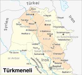
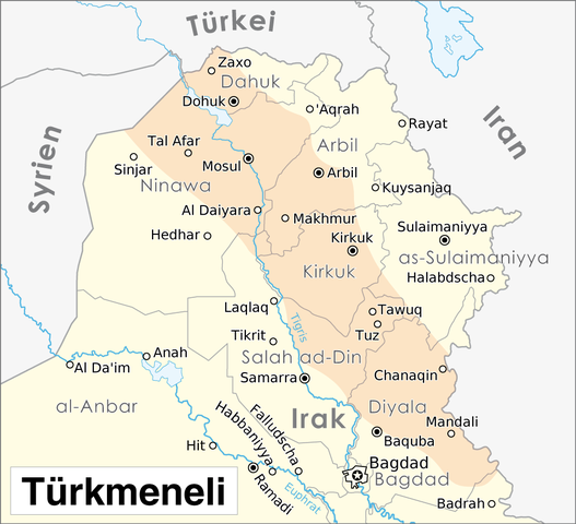
Deutsch: Karte von Türkmeneli |
| Date | |
| Source |
Self made, using
and for the localization of Türkmeneli |
| Author | Maximilian Dörrbecker (Chumwa) |
| Permission (Reusing this file) |
I, the copyright holder of this work, hereby publish it under the following license: This file is licensed under the Creative Commons Attribution-Share Alike 2.5 Generic license.
Sie dürfen das Bild zu den folgenden Bedingungen nutzen:
|
.png)
File history
Click on a date/time to view the file as it appeared at that time.
| Date/Time | Thumbnail | Dimensions | User | Comment | |
|---|---|---|---|---|---|
| current | 17:26, 8 October 2009 | | 1,012 × 922 (213 KB) | Chumwa (talk | contribs) | {{Information |Description= {{ de }} Karte von Türkmeneli |Source=Self made, using * :File:Autonome Region Kurdistan (Karte).png|this map]] as basis |Date=2009-10 |Author= Maximilian Dörrbecker (Chumwa) |
You cannot overwrite this file.
File usage on Commons
The following page uses this file:
File usage on other wikis
The following other wikis use this file:
- Usage on ar.wikipedia.org
- Usage on arz.wikipedia.org
- Usage on de.wikipedia.org
- Usage on en.wikipedia.org
- Usage on tr.wikipedia.org