File:Kashmir map 2020 skirmish.svg
Jump to navigation
Jump to search

Size of this PNG preview of this SVG file: 764 × 600 pixels. Other resolutions: 306 × 240 pixels | 611 × 480 pixels | 978 × 768 pixels | 1,280 × 1,005 pixels | 2,560 × 2,010 pixels | 2,160 × 1,696 pixels.
Original file (SVG file, nominally 2,160 × 1,696 pixels, file size: 206 KB)
Captions
Captions
Add a one-line explanation of what this file represents
Summary
[edit]| Description |
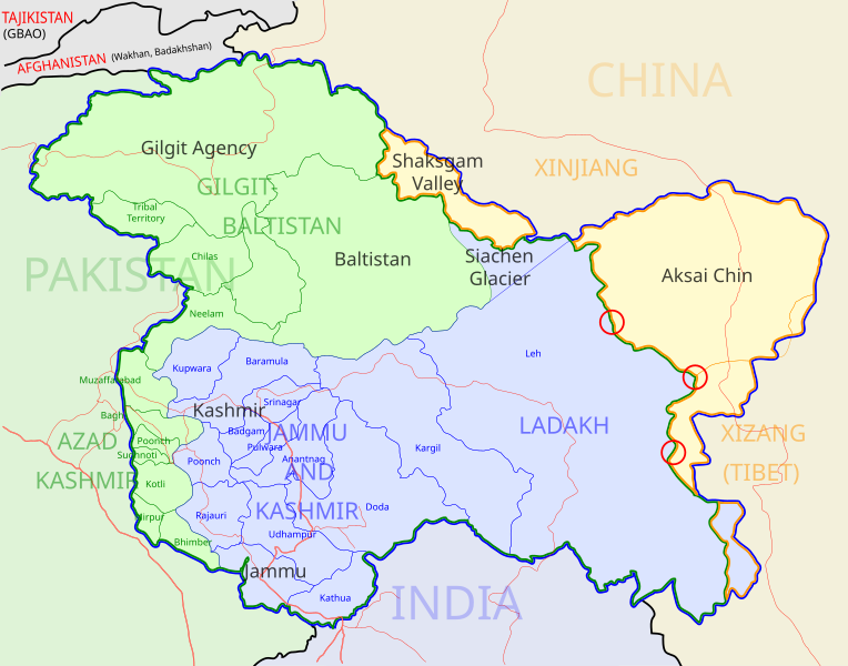
English: A map of the disputed Kashmir region created by Planemad; altered to show new jurisdictions and 2020 skirmish locations by Soumya-8974 in November 2020. The red circles mark the rough locations of the conflicts at the the Galwan Valley (top), Hot Springs, Chang Chenmo Valley checkpoint (middle), and Pangong Tso (near the bottom). |
| Date | |
| Source | File:Kashmir map.svg |
| Author | Soumya-8974 |
| Other versions |
[]
Others[edit]
|
.svg)


Licensing
[edit]
This file is licensed under the Creative Commons Attribution-Share Alike 3.0 Unported license.
- You are free:
- to share – to copy, distribute and transmit the work
- to remix – to adapt the work
- Under the following conditions:
- attribution – You must give appropriate credit, provide a link to the license, and indicate if changes were made. You may do so in any reasonable manner, but not in any way that suggests the licensor endorses you or your use.
- share alike – If you remix, transform, or build upon the material, you must distribute your contributions under the same or compatible license as the original.
File history
Click on a date/time to view the file as it appeared at that time.
| Date/Time | Thumbnail | Dimensions | User | Comment | |
|---|---|---|---|---|---|
| current | 14:24, 20 November 2020 | | 2,160 × 1,696 (206 KB) | Sbb1413 (talk | contribs) | Uploaded a work by {{U|Soumya-8974}} from [{:File:Kashmir map.svg]] with UploadWizard |
You cannot overwrite this file.
File usage on Commons
The following 11 pages use this file:
- File:Kashmir-map-zh.svg
- File:Kashmir map-es.svg
- File:Kashmir map-hi.svg
- File:Kashmir map-ks.png
- File:Kashmir map.svg
- File:Kashmir map (old).svg
- File:Kashmir map 2019 Balakot airstrike.svg
- File:Kashmir map 2020 skirmish.svg
- File:Kashmir map as.svg
- File:কাশ্মীরের মানচিত্র.svg
- Template:Other versions/Kashmir map