File:Kashmir map big.jpg
Jump to navigation
Jump to search

Size of this preview: 522 × 600 pixels. Other resolutions: 209 × 240 pixels | 418 × 480 pixels | 668 × 768 pixels | 891 × 1,024 pixels | 1,951 × 2,242 pixels.
Original file (1,951 × 2,242 pixels, file size: 2.32 MB, MIME type: image/jpeg)
Captions
Captions
Add a one-line explanation of what this file represents
Pir gali shahdra Sharif
Summary
[edit]| Description |
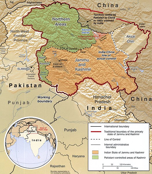
English: The disputed area of Kashmir.
|
||
| Date | CREATED/PUBLISHED | ||
| Source |
|
||
| Author | Central Intelligence Agency, Washington, 2002 |

Licensing
[edit]
| This image is a work of a Central Intelligence Agency employee, taken or made as part of that person's official duties. As a Work of the United States Government, this image or media is in the public domain in the United States.
|

|
Old file history
[edit]
taken from de.wiki there under PD with description
File history
Click on a date/time to view the file as it appeared at that time.
| Date/Time | Thumbnail | Dimensions | User | Comment | |
|---|---|---|---|---|---|
| current | 17:04, 2 December 2018 | | 1,951 × 2,242 (2.32 MB) | Ras67 (talk | contribs) | new cropped from LOC's high resolution TIFF |
| 22:23, 7 March 2006 |  | 985 × 1,131 (274 KB) | Sven-steffen arndt (talk | contribs) |
You cannot overwrite this file.
File usage on Commons
The following 4 pages use this file:
File usage on other wikis
The following other wikis use this file:
- Usage on ar.wikipedia.org
- Usage on ast.wikipedia.org
- Usage on as.wikipedia.org
- Usage on azb.wikipedia.org
- Usage on az.wikipedia.org
- Usage on ba.wikipedia.org
- Usage on be-tarask.wikipedia.org
- Usage on be.wikipedia.org
- Usage on bh.wikipedia.org
- Usage on bn.wikipedia.org
- Usage on ca.wikipedia.org
- Usage on cs.wikipedia.org
- Usage on diq.wikipedia.org
- Usage on en.wikipedia.org
- Usage on eo.wikipedia.org
- Usage on es.wikipedia.org
- Cachemira (región)
- Estado de Jammu y Cachemira
- Yihadismo
- Guerra sino-india
- Valle Shaksgam
- Conflicto de Cachemira
- Línea de control real
- Línea de control
- Insurgencia en Jammu y Cachemira
- Incidentes fronterizos entre India y Pakistán de 2013
- Frontera entre China y Pakistán
- Frontera entre Pakistán e India
- Usage on eu.wikipedia.org
- Usage on fa.wikipedia.org
View more global usage of this file.