File:Kisimul Castle Map Labelled-fr.png
Jump to navigation
Jump to search

Size of this preview: 624 × 599 pixels. Other resolutions: 250 × 240 pixels | 500 × 480 pixels | 800 × 768 pixels | 1,067 × 1,024 pixels | 2,480 × 2,381 pixels.
Original file (2,480 × 2,381 pixels, file size: 888 KB, MIME type: image/png)
Captions
Captions
Add a one-line explanation of what this file represents
Summary
[edit]
| Description |
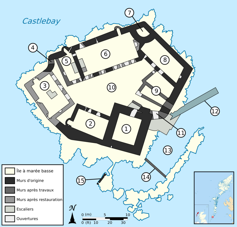
English: Floor plan of Kisimul Castle, Scotland, United Kingdom.
Keep
Kitchen
Tanist House
Postern
Marion of the Head's Addition
Great Hall
Watchtower
Chapel
Gockman's House
Courtyard
Gate
Slipway
Creek
Breakwater wall
Crew's house
Français : Plan au sol du château de Kisimul, Écosse, Royaume-Uni.
Donjon
Cuisines
Tanist House
Poterne
Marion of the Head's Addition
Great Hall
Tour de guet
Chapelle
Gockman's House
Cour
Entrée du château
Jetée
Crique
Mur brise lame
Maison de l'équipage |
||
| Date | |||
| Source |
Own work - Source of data :
|
||
| Author | Rémih | ||
| Other versions | |||
| PNG development |
|
| Object location | | View this and other nearby images on: OpenStreetMap |
|---|
Licensing
[edit]
I, the copyright holder of this work, hereby publish it under the following licenses:

|
Permission is granted to copy, distribute and/or modify this document under the terms of the GNU Free Documentation License, Version 1.2 or any later version published by the Free Software Foundation; with no Invariant Sections, no Front-Cover Texts, and no Back-Cover Texts. A copy of the license is included in the section entitled GNU Free Documentation License. |
This file is licensed under the Creative Commons Attribution-Share Alike 3.0 Unported, 2.5 Generic, 2.0 Generic and 1.0 Generic license.
- You are free:
- to share – to copy, distribute and transmit the work
- to remix – to adapt the work
- Under the following conditions:
- attribution – You must give appropriate credit, provide a link to the license, and indicate if changes were made. You may do so in any reasonable manner, but not in any way that suggests the licensor endorses you or your use.
- share alike – If you remix, transform, or build upon the material, you must distribute your contributions under the same or compatible license as the original.
You may select the license of your choice.
File history
Click on a date/time to view the file as it appeared at that time.
| Date/Time | Thumbnail | Dimensions | User | Comment | |
|---|---|---|---|---|---|
| current | 23:13, 12 February 2011 | | 2,480 × 2,381 (888 KB) | Rémih (talk | contribs) | change in colors and font |
| 17:03, 12 February 2011 |  | 2,480 × 2,381 (906 KB) | Rémih (talk | contribs) | {{Information |Description ={{en|1=Floor plan of Kisimul Castle, Scotland, United Kingdom.}} {{fr|1=Plan au sol du château de Kisimul, Écosse, Royaume-Uni.}} |Source ={{own}} |Author =Rémih |Date =2011/02/12 |
You cannot overwrite this file.
File usage on Commons
There are no pages that use this file.
File usage on other wikis
The following other wikis use this file:
- Usage on fr.wikipedia.org