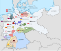
File:Länder der Weimarer Republik.svg
From Wikimedia Commons, the free media repository
Jump to navigation
Jump to search

Size of this PNG preview of this SVG file: 715 × 599 pixels. Other resolutions: 286 × 240 pixels | 573 × 480 pixels | 916 × 768 pixels | 1,222 × 1,024 pixels | 2,444 × 2,048 pixels | 976 × 818 pixels.
Original file (SVG file, nominally 976 × 818 pixels, file size: 877 KB)
File information
Structured data
Captions
Captions
Add a one-line explanation of what this file represents
Summary
[edit]| DescriptionLänder der Weimarer Republik.svg |
Deutsch: Eine Karte der Länder der Weimarer Republik und ihren Flaggen, nach der Einigung Thüringens 1920 und vor Preußens Annexion Pyrmonts 1921 English: A map of the states of the Weimar Republic and their flags, after the unification of Thuringia in 1920 and before the Prussian annexation of Pyrmont in 1921 |
| Date | |
| Source |
This file was derived from: Weimar Republic states map.svg |
| Author | Shadowxfox, Alphathon |
| Permission (Reusing this file) |
This file is licensed under the Creative Commons Attribution-Share Alike 3.0 Unported license.
|
File history
Click on a date/time to view the file as it appeared at that time.
| Date/Time | Thumbnail | Dimensions | User | Comment | |
|---|---|---|---|---|---|
| current | 18:54, 7 July 2023 |  | 976 × 818 (877 KB) | Fippe (talk | contribs) | {{Information |Description = {{de|Eine Karte der Länder der Weimarer Republik und ihren Flaggen, nach der Einigung Thüringens 1920 und vor Preußens Annexion Pyrmonts 1921}}{{en|A map of the states of the Weimar Republic and their flags, after the unification of Thuringia in 1920 and before the Prussian annexation of Pyrmont in 1921}} |Date = 2023-07-07 |Source = {{dF|Weimar Republic states map.svg}} |Author = {{U|Shadowxfox}}, {{U|Alphathon}} |Permission = {{cc-by-sa-3.0}} }} [[Category:Maps... |
You cannot overwrite this file.
File usage on Commons
The following 2 pages use this file:
File usage on other wikis
The following other wikis use this file:
- Usage on de.wikipedia.org
- Usage on fi.wikipedia.org
Metadata
This file contains additional information such as Exif metadata which may have been added by the digital camera, scanner, or software program used to create or digitize it. If the file has been modified from its original state, some details such as the timestamp may not fully reflect those of the original file. The timestamp is only as accurate as the clock in the camera, and it may be completely wrong.
| Width | 975.66052 |
|---|---|
| Height | 817.62897 |