File:Lake Success, California ESA373671.jpg
Original file (1,920 × 1,628 pixels, file size: 7.68 MB, MIME type: image/jpeg)
Captions
Captions
Summary
[edit]| Description |
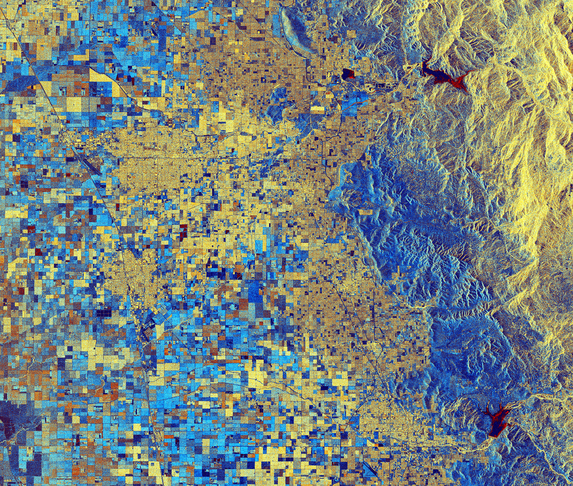
English: California has seen some heavy rains recently after years of drought, filling many of the state’s reservoirs. The rising waters are evident in this radar image from the Copernicus Sentinel-1 satellite mission over part of the San Joaquin Valley.
The three water bodies pictured here are Lake Kawhea in the upper right, Bravo Lake to its left and Lake Success in the lower right. This image was created by combining two scans from Sentinel-1’s radar on 15 December and 26 January, and assigning each scan a colour. Combined, the colours reveal changes, such as the red colouring in the reservoirs showing the water level increase. Officials have begun to release water from Lake Success as heavy rains have nearly filled it to capacity, and the outflow is sometimes exceeding the inflow in these days. The problem of too much water is in stark contrast from the situation in previous years, when drought led to water shutoffs and cutoffs, severely hindering yields in the San Joaquin Valley – a major agricultural region. Major crops include grapes, cotton, nuts and fruits, with productivity relying on irrigation from surface water diversions and groundwater pumping from wells. Agricultural structures dominate this radar composite image. Like the reservoirs, colours reveal changes between December and January such as vegetation growth or harvests. Along the right side of the image, we can see the foothills of the Sierra Nevada mountains. This image is also featured on the Earth from Space video programme. |
| Date | |
| Source | http://www.esa.int/spaceinimages/Images/2017/02/Lake_Success_California |
| Author | European Space Agency |
| Permission (Reusing this file) |
contains modified Copernicus Sentinel data (2016-17), processed by ESA ,CC BY-SA 3.0 IGO |
| Other versions |
|
| Title | Lake Success, California |
| Set | Earth observation image of the week |
| System | Copernicus |
| Mission | Sentinel-1 |
| Location | California |
| Activity | Observing the Earth |
| Keywords | Lake; Lakes; Agriculture; Water (fresh); Satellite image |

Licensing
[edit]
This media was created by the European Space Agency (ESA).
Where expressly so stated, images or videos are covered by the Creative Commons Attribution-ShareAlike 3.0 IGO (CC BY-SA 3.0 IGO) licence, ESA being an Intergovernmental Organisation (IGO), as defined by the CC BY-SA 3.0 IGO licence. The user is allowed under the terms and conditions of the CC BY-SA 3.0 IGO license to Reproduce, Distribute and Publicly Perform the ESA images and videos released under CC BY-SA 3.0 IGO licence and the Adaptations thereof, without further explicit permission being necessary, for as long as the user complies with the conditions and restrictions set forth in the CC BY-SA 3.0 IGO licence, these including that:
See the ESA Creative Commons copyright notice for complete information, and this article for additional details.
|
 | |
This file is licensed under the Creative Commons Attribution-ShareAlike 3.0 IGO license. Attribution: ESA/Copernicus, CC BY-SA IGO 3.0
| ||
File history
Click on a date/time to view the file as it appeared at that time.
| Date/Time | Thumbnail | Dimensions | User | Comment | |
|---|---|---|---|---|---|
| current | 15:12, 6 May 2017 | | 1,920 × 1,628 (7.68 MB) | Fæ (talk | contribs) | European Space Agency, Id 373671, http://www.esa.int/spaceinimages/Images/2017/02/Lake_Success_California, User:Fæ/Project_list/ESA |
You cannot overwrite this file.
File usage on Commons
The following 3 pages use this file:
File usage on other wikis
The following other wikis use this file:
- Usage on ar.wikipedia.org
- Usage on bg.wikipedia.org
- Usage on ca.wikipedia.org
- Usage on en.wikipedia.org
- Usage on fa.wikipedia.org
- Usage on he.wikipedia.org
- Usage on www.wikidata.org