File:LeasideEastYorkRiverdaleDonValleyThorncliffe.jpg
Jump to navigation
Jump to search

Size of this preview: 459 × 600 pixels. Other resolutions: 184 × 240 pixels | 367 × 480 pixels | 588 × 768 pixels | 1,038 × 1,356 pixels.
Original file (1,038 × 1,356 pixels, file size: 559 KB, MIME type: image/jpeg)
Captions
Captions
Add a one-line explanation of what this file represents
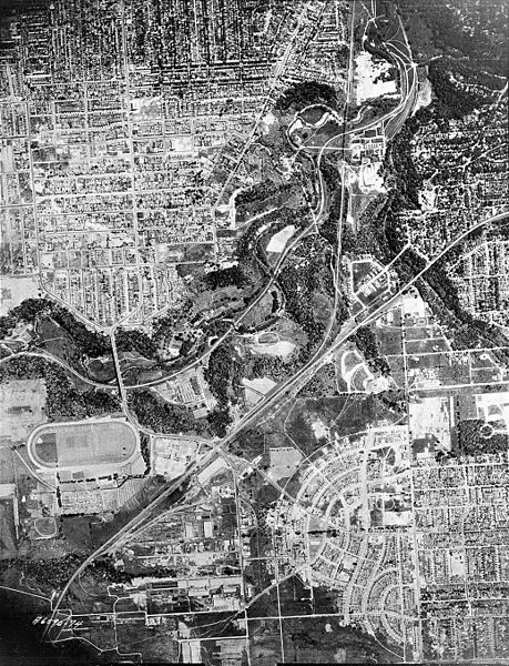
| Description | Aerial view of Leaside (bottom right), Thorncliffe harness racing track (bottom left) (today's Thorncliffe Park high density residential neighbourhood), the Don Valley (middle and top right), East York (middle, above Don Valley), Moore Park/Rosedale (right edge, middle and towards top) and Riverdale/parts of former City of Toronto (top left and middle). South is at top of photo, north is at bottom. | ||
| Date | |||
| Source |
|
||
| Author | James Salmon Collection | ||
| Permission (Reusing this file) |
Copyright expired. As pre-1946 Canadian image, also public domain in U.S. |
This Canadian work is in the public domain in Canada because its copyright has expired due to one of the following:
it was not subject to Crown copyright, and
|
 |
This work is in the public domain in the United States because it meets three requirements:
For background information, see the explanations on Non-U.S. copyrights.
Image was public domain in Canada prior to the URAA date |
File history
Click on a date/time to view the file as it appeared at that time.
| Date/Time | Thumbnail | Dimensions | User | Comment | |
|---|---|---|---|---|---|
| current | 17:17, 23 March 2008 | | 1,038 × 1,356 (559 KB) | Finavon (talk | contribs) | border cropped |
| 21:40, 19 November 2007 |  | 1,050 × 1,378 (568 KB) | Skeezix1000 (talk | contribs) | {{Information |Description=Aerial view of Leaside (bottom right), Thorncliffe harness racing track (bottom left) (today's Thorncliffe Park high density residential neighbourhood), the Don Valley (middle and top right), East York (middle, above Don Valley) |
You cannot overwrite this file.
File usage on Commons
There are no pages that use this file.