File:Leyte map annotated.jpg
Jump to navigation
Jump to search

Size of this preview: 413 × 600 pixels. Other resolutions: 165 × 240 pixels | 330 × 480 pixels | 1,001 × 1,454 pixels.
Original file (1,001 × 1,454 pixels, file size: 251 KB, MIME type: image/jpeg)
Captions
Captions
Add a one-line explanation of what this file represents

|
This battle map image could be re-created using vector graphics as an SVG file. This has several advantages; see Commons:Media for cleanup for more information. If an SVG form of this image is available, please upload it and afterwards replace this template with
{{vector version available|new image name}}.
It is recommended to name the SVG file “Leyte map annotated.svg”—then the template Vector version available (or Vva) does not need the new image name parameter. |


Summary
[edit]
| Description |
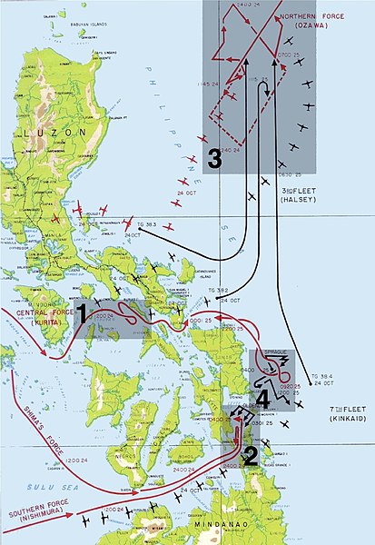
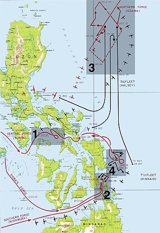
English: The four engagements of the battle of Leyte Gulf:
Español: Mapa de los cuatro encuentros de la Batalla del Golfo de Leyte. |
| Date | 24 October 2004 (original upload date) |
| Source | |
| Author |
|
| Permission (Reusing this file) |
PD-AUTHOR; Released into the public domain (by the author). |
| Other versions | File:Annotated map of Battle of Leyte Gulf.png |
Licensing
[edit]
| This work has been released into the public domain by its author, Gdr at en.wikipedia. This applies worldwide. In some countries this may not be legally possible; if so: Gdr at en.wikipedia grants anyone the right to use this work for any purpose, without any conditions, unless such conditions are required by law.
|
Original upload log
[edit]
The original description page was here. All following user names refer to en.wikipedia.
- 2005-12-15 19:07 Lhgodoy 1001×1454× (199460 bytes) Noise removal in original image
- 2004-10-24 11:00 Gdr 1001×1454× (246741 bytes) Map of the [[battle of Leyte Gulf]], annotated with regions and numbers for the engagements. A public domain modification of [[Image:Leyte Gulf.jpg]].{{PD-USGov-Military}}
This image is a derivative work of the following images:
- File:Map_of_Battle_of_Leyte_Gulf.jpg licensed with PD-USGov-Military-Army
- 2011-01-01T05:16:48Z File Upload Bot (Magnus Manske) 1000x1454 (188596 Bytes) {{BotMoveToCommons|en.wikipedia|year={{subst:CURRENTYEAR}}|month={{subst:CURRENTMONTHNAME}}|day={{subst:CURRENTDAY}}}} {{Information |Description={{en|Battle of Leyte Gulf Source: Scanned from Reports of General MacArthur (
File history
Click on a date/time to view the file as it appeared at that time.
| Date/Time | Thumbnail | Dimensions | User | Comment | |
|---|---|---|---|---|---|
| current | 18:04, 13 July 2011 | | 1,001 × 1,454 (251 KB) | Hohum (talk | contribs) | Cleanup |
| 12:17, 18 February 2005 |  | 1,001 × 1,454 (241 KB) | Walter (talk | contribs) |
You cannot overwrite this file.
File usage on Commons
The following page uses this file:
File usage on other wikis
The following other wikis use this file:
- Usage on azb.wikipedia.org
- Usage on bg.wikipedia.org
- Usage on ca.wikipedia.org
- Usage on cs.wikipedia.org
- Usage on da.wikipedia.org
- Usage on de.wikipedia.org
- Usage on en.wikipedia.org
- Usage on es.wikipedia.org
- Usage on eu.wikipedia.org
- Usage on fa.wikipedia.org
- Usage on fi.wikipedia.org
- Usage on fr.wikipedia.org
- Usage on he.wikipedia.org
- Usage on hu.wikipedia.org
- Usage on it.wikipedia.org
- Usage on ko.wikipedia.org
- Usage on nl.wikipedia.org
- Usage on nn.wikipedia.org
- Usage on no.wikipedia.org
- Usage on pl.wikipedia.org
- Usage on pnb.wikipedia.org
- Usage on pt.wikipedia.org
View more global usage of this file.