File:Libya Montes topography ESA380974.jpg
Jump to navigation
Jump to search

Size of this preview: 800 × 321 pixels. Other resolutions: 320 × 128 pixels | 640 × 256 pixels | 1,024 × 410 pixels | 1,280 × 513 pixels | 2,560 × 1,026 pixels | 8,985 × 3,600 pixels.
Original file (8,985 × 3,600 pixels, file size: 5.03 MB, MIME type: image/jpeg)
Captions
Captions
Add a one-line explanation of what this file represents
Summary
[edit]
| Description |
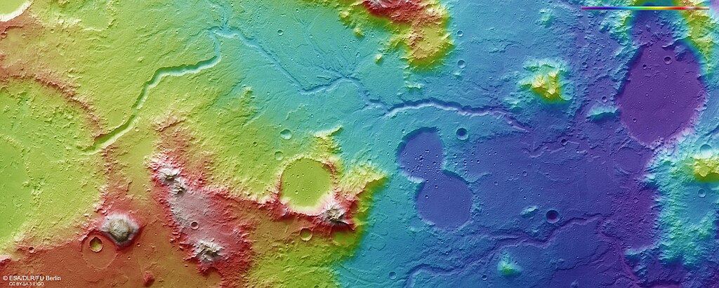
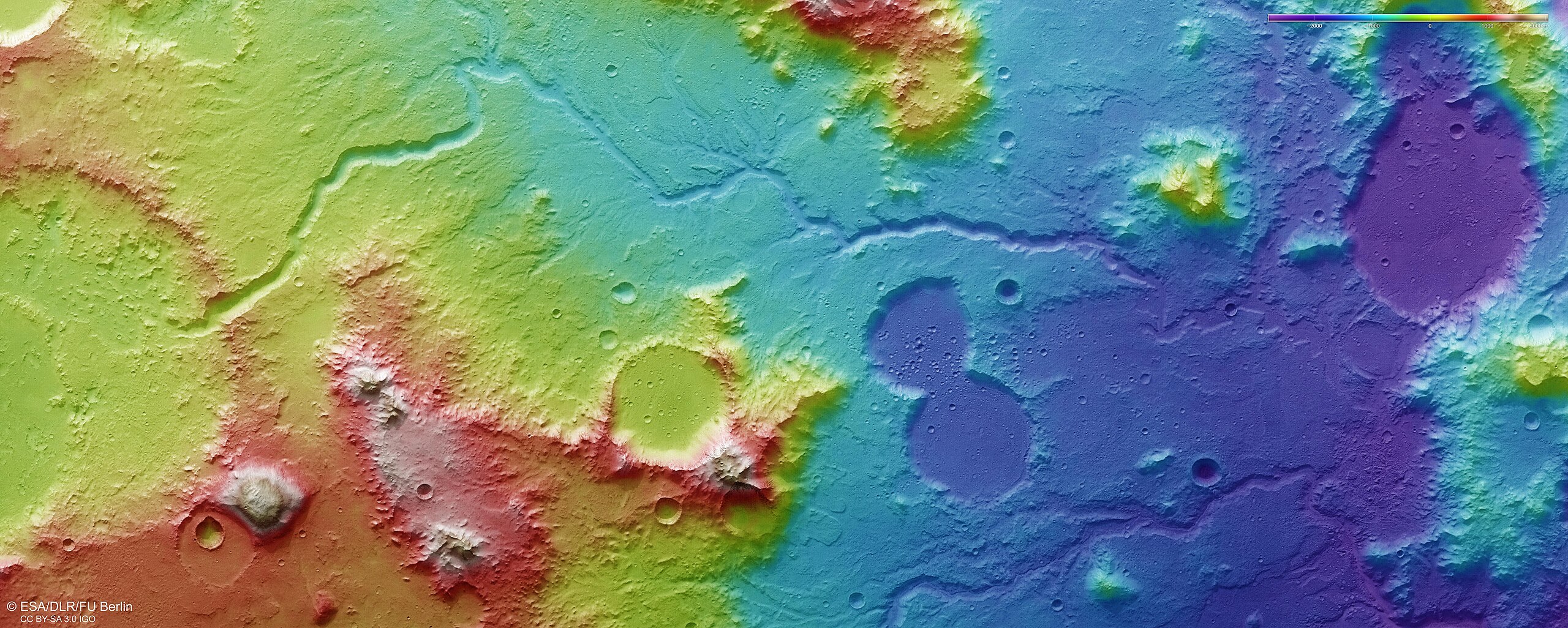
English: The colour-coded topographic view shows relative heights and depths of terrain in the Libya Montes region on Mars. As indicated in the key at top right, whites and reds represent the highest terrain, while blue/purple is the lowest.
The color-coded topographic view is based on a digital terrain model of the region, from which the topography of the landscape can be derived. This region was imaged on 21 February 2017 during Mars Express orbit 16647. The ground resolution is about 15 m/pixel and the images are centred on 90°E / 1°N. |
| Date | |
| Source | http://www.esa.int/spaceinimages/Images/2017/07/Libya_Montes_topography |
| Author | European Space Agency |
| Permission (Reusing this file) |
ESA/DLR/FU Berlin, ,CC BY-SA 3.0 IGO |
| Other versions |
|
| Title | Libya Montes topography |
| Mission | Mars Express |
| Activity | Space Science |
Licensing
[edit]
This media was created by the European Space Agency (ESA).
Where expressly so stated, images or videos are covered by the Creative Commons Attribution-ShareAlike 3.0 IGO (CC BY-SA 3.0 IGO) licence, ESA being an Intergovernmental Organisation (IGO), as defined by the CC BY-SA 3.0 IGO licence. The user is allowed under the terms and conditions of the CC BY-SA 3.0 IGO license to Reproduce, Distribute and Publicly Perform the ESA images and videos released under CC BY-SA 3.0 IGO licence and the Adaptations thereof, without further explicit permission being necessary, for as long as the user complies with the conditions and restrictions set forth in the CC BY-SA 3.0 IGO licence, these including that:
See the ESA Creative Commons copyright notice for complete information, and this article for additional details.
|
 | |
This file is licensed under the Creative Commons Attribution-ShareAlike 3.0 IGO license. Attribution: ESA/DLR/FU Berlin, CC BY-SA IGO 3.0
| ||
File history
Click on a date/time to view the file as it appeared at that time.
| Date/Time | Thumbnail | Dimensions | User | Comment | |
|---|---|---|---|---|---|
| current | 18:43, 12 February 2023 | 8,985 × 3,600 (5.03 MB) | Don-vip (talk | contribs) | high-res from dlr | |
| 10:01, 13 July 2017 | 1,920 × 769 (1.43 MB) | Fæ (talk | contribs) | European Space Agency, Id 380974, http://www.esa.int/spaceinimages/Images/2017/07/Libya_Montes_topography, User:Fæ/Project_list/ESA |
You cannot overwrite this file.
File usage on Commons
The following 3 pages use this file:
.jpeg&redirect=no)
File usage on other wikis
The following other wikis use this file:
- Usage on ru.wikipedia.org