File:Linguistic map of Italy.svg
Jump to navigation
Jump to search

Size of this PNG preview of this SVG file: 350 × 454 pixels. Other resolutions: 185 × 240 pixels | 370 × 480 pixels | 592 × 768 pixels | 789 × 1,024 pixels | 1,579 × 2,048 pixels.
Original file (SVG file, nominally 350 × 454 pixels, file size: 5.67 MB)
Captions
Captions
Add a one-line explanation of what this file represents
Any autoconfirmed user can overwrite this file from the same source. Please ensure that overwrites comply with the guideline.
Summary
[edit]| Description |
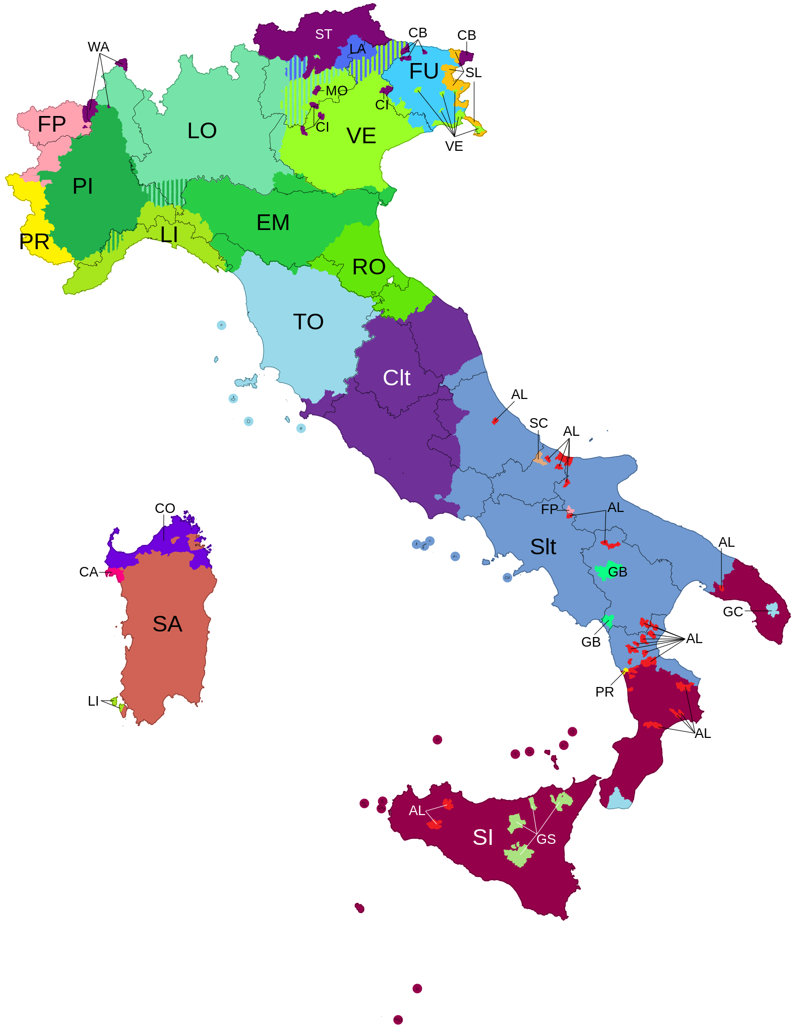
English: Projection: Equirectangular projection, N/S stretching 132,898 %.
Shapefile: ISTAT Confini amministrativi Comuni 2011. Simplified with Mapshaper using "Visvalingam / effective area" algorythm at 4%. Data: Vector version of File:Linguistic_map_of_Italy.png. Original data: (only for linguistic islands) F. Bruni, "Storia della Lingua Italiana" |
| Date | |
| Source | File:Linguistic_map_of_Italy.png |
| Author | Mikima |
| Other versions |
|

Licensing
[edit]
I, the copyright holder of this work, hereby publish it under the following license:
This file is licensed under the Creative Commons Attribution-Share Alike 4.0 International license.
- You are free:
- to share – to copy, distribute and transmit the work
- to remix – to adapt the work
- Under the following conditions:
- attribution – You must give appropriate credit, provide a link to the license, and indicate if changes were made. You may do so in any reasonable manner, but not in any way that suggests the licensor endorses you or your use.
- share alike – If you remix, transform, or build upon the material, you must distribute your contributions under the same or compatible license as the original.
Suggested Legend
[edit]

| ||||||
File history
Click on a date/time to view the file as it appeared at that time.
| Date/Time | Thumbnail | Dimensions | User | Comment | |
|---|---|---|---|---|---|
| current | 20:26, 29 February 2024 | | 350 × 454 (5.67 MB) | Cosocosa (talk | contribs) | Corrected bilingual areas where Ladin is spoken (Source: https://commons.wikimedia.org/wiki/File:Linguistic_map_of_Italy.png) |
| 11:14, 14 May 2018 |  | 350 × 454 (5.89 MB) | Glz19 (talk | contribs) | Separation of Emiliano and Romagnolo (as stated in UNESCO Atlas of the World's Languages in Danger) | |
| 11:04, 22 February 2016 |  | 350 × 454 (4.57 MB) | Mikima (talk | contribs) | Removed hardcoded legend. | |
| 10:50, 22 February 2016 |  | 350 × 575 (4.58 MB) | Mikima (talk | contribs) | again fonts | |
| 10:26, 22 February 2016 |  | 350 × 575 (4.57 MB) | Mikima (talk | contribs) | still fonts | |
| 10:18, 22 February 2016 |  | 350 × 575 (5.6 MB) | Mikima (talk | contribs) | still fonts | |
| 10:15, 22 February 2016 |  | 350 × 575 (5.6 MB) | Mikima (talk | contribs) | again fonts | |
| 09:50, 22 February 2016 |  | 350 × 575 (5.51 MB) | Mikima (talk | contribs) | fixing font (again) | |
| 09:47, 22 February 2016 |  | 350 × 575 (5.51 MB) | Mikima (talk | contribs) | fixed font | |
| 09:33, 22 February 2016 |  | 350 × 575 (5.53 MB) | Mikima (talk | contribs) | Added legend |
You cannot overwrite this file.
File usage on Commons
The following 9 pages use this file:
- User:Chumwa/OgreBot/Travel and communication maps/2016 February 20-29
- User:Chumwa/OgreBot/Travel and communication maps/2018 May 11-20
- User:Chumwa/OgreBot/Travel and communication maps/2024 February 20-29
- User:J budissin/Uploads/BiH/2018 May 11-20
- File:Linguistic Map of Italy.png (file redirect)
- File:Linguistic Map of Italy.svg.png (file redirect)
- File:Linguistic map of Italy.png
- File:Linguistic map of Italy.svg
- File:Linguistic map of Italy - Legend.svg
File usage on other wikis
The following other wikis use this file:
- Usage on bg.wikipedia.org
- Usage on ca.wikipedia.org
- Usage on cs.wikipedia.org
- Usage on fr.wikipedia.org
- Usage on it.wikipedia.org
- Usage on oc.wikipedia.org